On August 5th we started work on the 2020 phase of creating a new channel on the River Nar between Castle Are and West Acre: replacing a dredged, high-level leat channel running along the contour line at the edge of the floodplain with a meandering, shallow and gravelly channel at the centre-line of the floodplain and in sync with the gradient line of the valley.
One key aim of this WEG funded project has been to increase the “hydrological connectivity” between the river and the floodplain. The channel cross-sectional profile is based on the few reference reaches I have found, including a relic, unmodified “lost” channel at Emmanuel’s Common. The new channel is relatively wide and shallow (70 – 80 cm deep and 6 meters wide), designed to flow at bankful or overspill for some of the year. We are also cutting slightly higher ephemeral channels that will also flow at these times. In addition we’re not infilling the old channels: rather we’re setting out LWD or gravel bars to retain water levels in these old channels to create another type of wetland habitat, with some groundwater flow and the capacity to take a proportion of high flows: I see them as man-made oxbows of sorts.
Finally, I have incorporated into the design a short 250 meter section of so-called “Stage Zero” channel, partly to add to the overall variety of the project, partly to learn more about what happens with Stage Zero type treatments in a low-energy, chalk-stream setting, partly to retain what has happened naturally there anyway.
To learn a bit more about the theory of Stage Zero, please see my previous post, or better still the look up work of Colin Thorne, Paul Powers and Brian Cluer … but in simple terms, Stage Zero is a way to replicate the pre-historic river, characterised by multiple channels, braiding across the floodplain floor and it involves, for example, regrading the now modified, degraded valley and then leaving the river to do its thing in terms of re-establishing a more natural anastomosed channel form from scratch. You set the process in motion, but the river does the work.
In this reach we are simply diverting a proportion of the flow across a wet woodland area, where it will run unconstrained to reunite with the main stream after about 250 meters. In designing this Stage Zero reach and trying to figure out how to get it to work I have bumped into a few basic issues which I suspect will apply to most projects like this in an English chalk-stream setting. They are of a practical, rather than theoretical nature, but they might be interesting to others planning this kind of thing.
Key to getting something like this to work (and please bear in mind that I haven’t yet got this one “to work” … I’m just building it, and quite how well it functions has yet to be discovered) is how to handle the step up and the step down: after all, you are trying to lift the flow from the bed level of the river on to the floodplain surface (and then you have to let it down again). That sounds simple enough, but English chalk-streams rarely divide into large enough holdings to make this quite as simple as it sounds. Let’s say your channel is one meter deep and the gradient of the chalk-stream is 1 in 600: a sudden step-up of one meter will likely impound the flow a long way upstream. That could cause problems if the upstream land & river are owned by someone else, especially if they aren’t bought in or involved with the project. It could also cause problems in that an impounded channel is generally less desirable habitat: you might be robbing Peter to pay Paul.
The “Stage Zero” in question here is in fact partly replacing a serendipitously self-generated “Stage Zero” caused by a breach in the higher level mill-leat, through which the water is pouring across the floodplain through a willow carr. So the mill-leat has solved the issue of how to create that step, by gradually lifting the river bed relative to the floodplain, at the expense of a long, impounded reach, which the rest of our project is designed to replace. Nevertheless, mill-leats might well be a great way to solve the issue of handling the step-up and if I were looking for projects sites I’d think carefully about the potential for mill-leats to take care of this primary design issue.
However, as soon as we connect our new channel we will lose the advantage of the mill-leat and so I have had to come up with another way to get the water up on to the floodplain surface. I have designed a two-fold solution. The plan below should help make sense of the following description.

For various other reasons the new, meandering channel has been designed to flow just off-centre of the floodplain along a seam of gravel which coincided with the desired bed-levels. I have used this to tease a small amount out of each of the 16 riffles upstream to create a bed-level at the main take-off point that is just a bit higher than it could have been: 21:60 (riffle 16 in the plan above) against a floodplain surface of 22:20, as supposed to the 21:45 to 22:20 in my first design. Now my step up is only 60 cm, instead of 75 cm.
Although the floodplain surface beside the river is 22:20, it is in fact a little lower than this slightly to the south (22:10) and if I then travel down the valley a small amount, I find a floodplain surface that is 22:00 … and I also bump into the flow currently coming out of the high-level breach (round about the letter O in ZERO in the plan). So, I have cut a low sill in the southern bank of the main stream (set at 22:05 or so) at the take-off point and a wide and shallow channel that fans wider still as it goes away from the edge of the river to coincide with the point where the valley is at 22:00.
Now, when the water depth in the main stream exceeds 45 cm (which I anticipate it will when the ranunculus beds establish downstream) a proportion of the flow will spill across this low-cut sill and fan away into the woods and the Stage Zero section. The proportion will vary depending on flow levels but the channel d’stream of the take-off point is slightly smaller than upstream (riffles 17 to 24), and I have a pile of gravel and large limbs of LWD sitting beside the river ready to fine-tune the split.

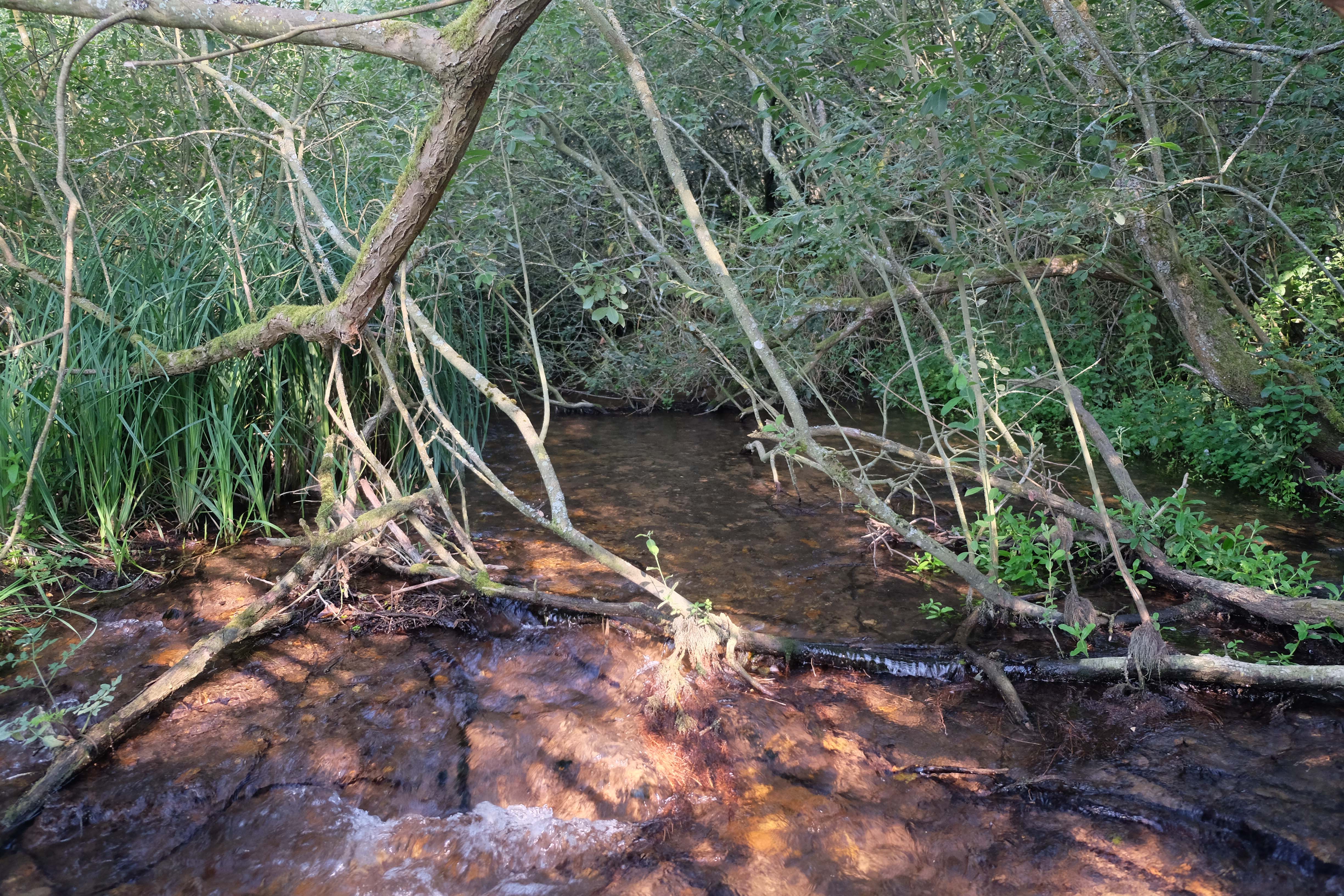
 The images above show the excavation of and finished Stage Zero cut-off, with the main channel to the right and the willow carr setting of the Stage Zero channel back left.
As a secondary source of flow, I have also taken advantage of the need for the entire project to enhance the so-called hydrological connectivity in the floodplain: an arrow-straight and long since forgotten ditch runs down the centre line of the floodplain. We will modify this ditch into a secondary ephemeral channel and set the take-off so that a proportion of higher flows run down it. This secondary channel comes off the new channel much further upstream where the bed level is 22:00 (upstream of riffle 8), so it will have the head to drive water to the Stage Zero section. If the d’stream cut-off point doesn’t work for some unforeseen reason, then this one should. Either way, we’ll have a network of channels creating a variety of free-flowing habitats, without any undue impoundments.
 The drone shot above taken by the plant contractor Gary of GRD Sales shows the emerging main channel, with the Stage Zero cut off in the distance by the willows. The secondary Stage Zero feeder channel will come from enhancing the old ditch which runs along the left of the photo.
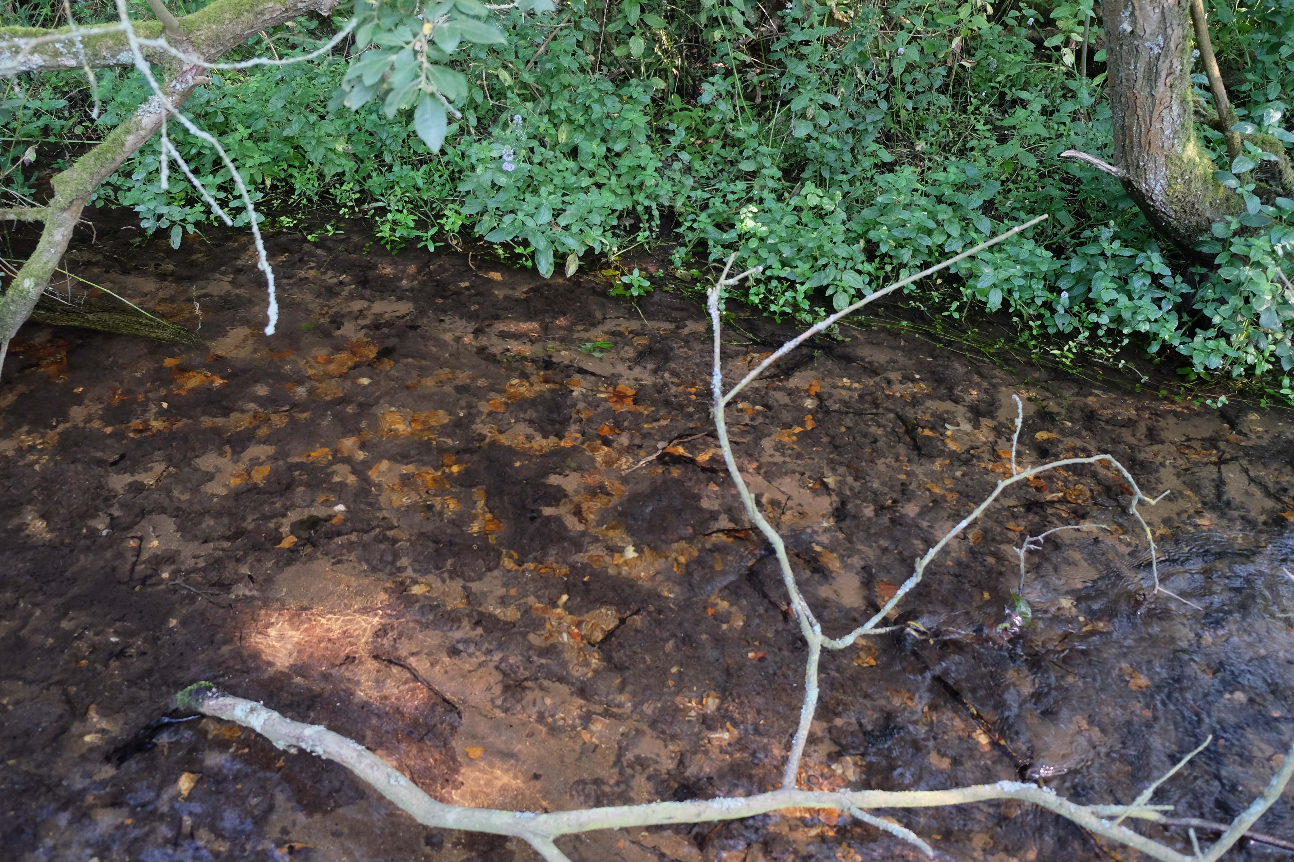
As for the step-down … well the existing serendipitous Stage Zero has started that process already and we’ll just let it continue (see the pics below). Interestingly, the process of channel creation is happening quite quickly at this lower junction, where the gradient of the step change is giving the energy required to accelerate the process: again maybe something to consider when designing other Stage Zero projects. It has been theorised that low gradient sections might be more suitable, but the lower the gradient, the lower the energy and therefore, I suspect, the slower the process.
The two shots below shows how the existing self-generated Stage Zero channel is cutting a stream bed at the downstream end and – interestingly – how the few gravels present in the upper layers of the floodplain peat have settled out to form an emerging river bed.