
Note: this blog is critical of the way WFD assessments have been applied on the upper River Ivel. It’s no secret that I think this WFD assessment process needs to be improved. Too many headwater chalk streams are effectively unprotected by what should be a powerful statutory driver. The criticism is meant with the best of intentions, however, and I hope it will be taken in that spirit.
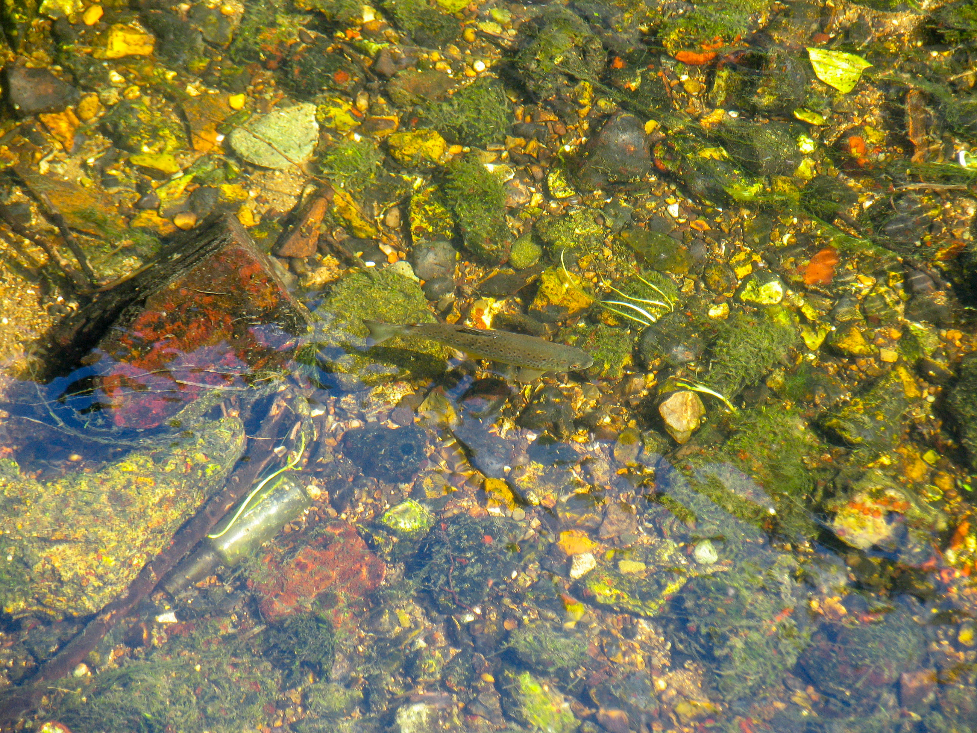
Although I have driven across its aquifer countless times on my way from London to Norfolk, until recently I wasn’t that familiar with the River Ivel, or the several chalk streams around it that form the Ivel’s headwaters: the Hiz and Oughton, Purwell, Pix Brook and Cat Ditch. I stopped there once, in 2005, to take a few photographs for my anthology on chalk streams and managed to get the snap below of a small, wild trout near the springs of the Oughton. So I knew that these were chalk streams and that they held trout. And I also knew that they were, like many East Anglian streams, easy to pass over, unknown and perhaps unloved.
But not universally unknown and unloved. Not at all. More recently, whilst putting together the CaBA chalk stream strategy I corresponded with a band of people who cared deeply about their local stream (or rather, the lack of it) and who had for years been railing against its condition as a river action group called RevIvel.
The River Ivel, they claimed, was now a shadow of the river that it should be. It was being abstracted, to the point that it barely flowed. And yet the Environment Agency seemed relatively deaf to their concerns, while Affinity Water claimed that this wasn’t true, that the groundwater abstraction, such as it is, does not reduce natural flows in the River Ivel.
Last November Revivel invited me to sit in on their virtual AGM. I listened with growing dismay and sympathy, to a familiar tale of hair-pulling frustration as the group recounted the minutiae of their efforts to get their case taken seriously. I didn’t say much and I can’t remember exactly what I did say, but I guess it would have along the lines of advocating what I try to do when tilting a lance at those windmills of bureaucracy: get seriously forensic, arm yourself with data (they’d done a lot of this already) and tirelessly pick apart the inconsistencies that have allowed a priority river habitat to not actually exist as a river.
All okay advice. But I also suggested they pick up the phone to conservationist and technical consultant, John Lawson, and ask him to do an independent analysis of the abstraction in the catchment, because with that they would have a much stronger case. That was the really useful bit.
Until now the ‘science’ of analysing the impact of groundwater abstraction on chalk stream flows has been rather one sided, to say the least. Water companies have claimed over the years (not quite so much any more, I’m happy to say) that groundwater abstraction doesn’t reduce surface flows, and that the passage of water underground and its interaction with surface streams is of such unknowable complexity that only expert hydrogeologists can understand it.
Common sense might suggest that if a catchment can be seen as some kind of basin with a boundary, an inflow of water and an outflow (which it can, in fact), then if you add another form of outflow the former outflow will reduce, about as surely as an apple hitting the ground when it falls off a tree. But I and many others have succumbed to cognitive surrender when arguing with experts about this: defeated by befuddling terminology, incomprehensible maths and the problematic fact that we can’t see underground. Although it must be a tempting tactic to impose cognitive surrender on the layperson in the street who is wondering where his or her river has gone, it is surely also a self-defeating one. They might not have beaten your argument, but they’re still angry and suspicious. And they don’t go away.
The CaBA strategy was all about building bridges across this divide, because we’ll only really restore our chalk streams if we all honestly acknowledge what’s wrong with them and work together – river lovers and water companies, regulators and NGOs – to fix them. Recommendation 5, in the CaBA Chalk stream strategy advocates the evolution of a collaborative approach towards knowledge-sharing when it comes to assessing and managing the impact of abstraction on stream flows. Water companies and the EA should share what they know and their data, while stakeholders should be allowed to contribute to the debate at a technical level, instead of just railing outside the door with pitchforks.
This is where it is jolly useful to have a John Lawson on the team.
John has now completed his survey and analysis of the River Ivel, and although it does make for some uncomfortable reading (I think the case of the Ivel may be about the best (best as in worst!) example of how a muddle in the Water Framework Directive assessment can have disastrous knock-on impacts), I think it also marks the first and thus a very important step in this attempt to democratise knowledge and move forward together.
John’s survey has revealed that in terms of groundwater abstraction as a % of the natural recharge of the aquifer (A%R), the upper Ivel is among the most heavily abstracted chalk streams in the country, with 50% of the rain that reaches the aquifer taken by groundwater abstraction. Only a few other chalk streams, like the Darent, or upper Lea, are in that territory. It is hard to imagine this isn’t having a major impact on flows.
In other work, John has already demonstrated the close, mathematical relationship between groundwater levels and stream flows, with a highly predictive formula that equates stream flows to the height of the groundwater above the stream bed at the point of assessment, and the v-shape of a river valley: because as groundwater levels rise, not only do the springs flow faster and faster (because of increasing groundwater head), but also, because of the shape of a valley, a proportionately greater and greater surface area is exposed to the saturated zone of the aquifer.
The Lawson formula therefore is Q = aH2.5. (I have looked and looked but I cannot find any version of this formula in groundwater literature, although it is linked to an important part of Theis’ foundational groundwater paper of 1940, where he wrote that a new ‘development’ (an abstraction) from an aquifer must reduce former outflow and that the only way this can happen is by a ‘reduction in the thickness of the aquifer’. Note that in America, where much of the hydrogeological science comes from, many aquifers are not V shaped.)
I like to write equations in prose because then I understand them. In English therefore, the Lawson formula shows that (in a chalk valley): “flow equals the height of the groundwater level above a given point in the stream, multiplied by a constant (which accounts for the properties of the chalk), multiplied by 0.5 (to account for rising head / gravity) and squared (to account for the v-shape of the valley).
John’s formula fits every chalk stream he has looked at, including the Kennet, Tarrant, Test, Misbourne, Ver and now the Ivel. It is quite compelling therefore.
The question then becomes: has groundwater abstraction on this scale lowered groundwater levels in the Ivel catchment?
John’s lumped parameter model simulates changes in groundwater levels and flows. It gives a very good fit between recorded and modelled output on all those rivers mentioned above, now including the Ivel and it suggests that groundwater levels are between 4 to 6 meters lower than before groundwater abstraction began. Interestingly, the Environment Agency figures back this up.
As does historical research carried out by RevIvel and incorporated into John’s report. Data from the Royal Commission into Metropolitan Water Supplies in 1893 (which recorded the depth of water in wells in the valley) suggest that groundwater levels at that time were about 3 to 6m higher than recent groundwater levels.
The existence of 19th century functioning water mills at Blackhorse Mill and Norton Mill, the commercial water cress beds at Baldock and a trout hatchery and fisheries at Norton suggest that the Ivel Springs and Nortonbury Springs would once have flowed perennially – which they don’t now.
Meanwhile long-term rainfall records cannot account for these changes: winter rainfall has – if anything – increased, albeit the catchment may well be less absorbent than once it was.
All this adds up to a large reduction from natural flows according to John’s way of assessing the link between abstraction, groundwater levels and flow: the current abstraction of 13 Ml/d, accounts for an average flow loss over the full year of 11 Ml/d (85% of the amount abstracted), albeit the loss of flow as a % of the abstraction is much greater at high flows than low: over 100% at high flows, more like 45% at low flows. Read the Lawson formula carefully and you’ll see why in the part that represents the shape of the valley.
I have to say, for the sake of fairness, that Affinity Water (AW) has a different way of looking at this. Based on data collected during switch-off tests, AW argues that the cessation of abstraction appears to have only a very small impact on flows. They have concluded that the presence of semi-permeable layers in the chalk impedes the connection between the deeper, confined aquifer (the part under the semi-permeable layer from which AW abstracts water) and the unconfined aquifer (the uppermost layer of aquifer which is directly in contact with the stream).
John argues that the switch-off tests were not nearly long enough and only ever happened one at a time: so it would be impossible to discern any difference in flow because the tests could not have made any difference to regional groundwater levels away from the cones of depression around boreholes. Abstraction would have to cease altogether for about 18 months and we would need a good recharge of rain to rebalance groundwater levels in the aquifer.
Incredibly, at the that heart of this is a diversion of opinion over what actually causes flows to diminish as a result of groundwater abstraction. John, as explained, argues that groundwater levels across the whole valley are the fundamental driver, and that the cones of depression around boreholes cause only localised, smaller-scale impacts, separating the stream-bed from the water table, for example or lowering / inverting the groundwater gradient at the stream edge within the radius of the cone.
AW and, as far as we can tell, much of the expert community, sees the cones of depression as the fundamental mechanism that reduces flows: thus AW has argued that when these cones of depression have filled in – as they quite quickly will during switch-off tests – that dynamic-equilibrium (the balance of the water table between inflows and outflows) in the aquifer is re-established.
Dynamic-equilibrium is when outflows balance inflows over time. It can be a ‘natural’ dynamic equilibrium, or an ‘unnatural’ one. Add abstraction to a virgin aquifer and the equilibrium will be upset for a while (meaning outflows exceed inflows), until groundwater levels reduce, and thus the former natural outflows reduces and then you are back to a state of equilibrium, albeit an ‘unnatural’ one (see my previous post on the bucket aquifer and you will understand this, if you don’t already).
Cease abstraction at a given pump and – as John would argue – of course the cone of depression will fill in. When it has, that is conspicuously not the same as ‘natural’ dynamic equilibrium. What is happening to the water no longer abstracted? It’s not yet discernible in flows because it hasn’t yet lifted groundwater levels: it’s still filling up space in the aquifer.
So, we have some fundamental disagreements.
Happily, we’ve agreed to convene a workshop under the CaBA banner and to invite independent experts to look at the evidence and our arguments and see whether we can find common ground. I see this workshop as the first part of delivering on the Recommendation 5 in the chalk strategy.
**
Meanwhile, the poor River Ivel continues to hardly flow at all and the only measure of relief on the horizon is a tiny 0.5 Ml/d augmentation, which as RevIvel argue, is the wrong mitigation and not nearly enough even if it were the right one (augmentation is actually part of our proposal for a more sustainable future, but only as an emergency measure for resilience of water supply during extreme droughts).
AW has written “Evidence suggests that abstraction is not likely to have a significant impact on flows in the Ivel. As a result it is considered that the ecology is not impacted by abstraction and therefore any reduction or cessation of abstraction is unlikely to improve the ecological status of the Ivel.”
Whatever way you interpret the Ivel evidence, the idea that groundwater abstraction on that scale is having no impact on flows, or ecology, seems too incredible.
The trouble is, the Water Framework Directive assessment of the Ivel, is as unhelpful as AW’s statement above.
The Ivel is classified as a heavily modified waterbody (HMWB). No real reason to disagree with that, on the face of it. There are many relic mills. On the other hand there are mills on most chalk streams not deemed to be heavily modified. In fact the HMWB designation isn’t supposed to describe the degree to which a waterbody is modified by relic structures like mills. It exists to account for waterbodies whose modification provides an essential and current socio-economic benefit (like a runway at Heathrow airport, for example) so that the waterbody so deemed only has to achieve good ecological potential, not status (a lower bar) and does not have to achieve good status in those elements or supporting elements affected by the relevant modification.
You can see the sense of it, but there are collateral impacts of this HMWB designation on many chalk streams in eastern England, streams which are part of larger, lowland waterbodies where modifications are essential (sea-gates for example, or navigational locks), lowering the bar for their chalk stream headwaters, where there is no reason to diminish expectations for proper restoration to good status.
I have encountered this before on my local stream the Nar, where in 2011 the EA classified the lower man-made watercourse, “not heavily modified” even though its perched trapezoid channel very clearly had a current, vital socio-economic benefit (keeping water off thousands of acres of Fenland farmland) and the upper natural watercourse as heavily modified, even though all its modifications had become redundant by the end of the 19th century. Thus the EA had – based on some fish scores carried out in unrepresentative parts of the channel – set in train a designation which suggested that the very homogenous lower river didn’t need to be improved, and the natural but much degraded upper river, didn’t need to be improved either.
So, the HMWB status is the first problem.
The second, deriving from that, is the bewildering assessment of ‘good’ anyway.
In 2016 the assessment was more convincingly representative of the Ivel as we know it, at least in that the waterbody failed because it was assessed as ‘poor’ for macrophytes (unsurprising given the lack of flow) and as ‘does not support good’ for flow.
By 2019 it was back to good again. On other hand in 2019 the macrophytes were not assessed at all. In fact macrophytes have only ever been assessed on the upper Ivel in 2014 and 2016, as “moderate” then “poor”, both of which are failures of a WFD key element, leading therefore to an overall fail.
It is worth mentioning here that Ivel is not assessed for fish. Not at all. Never has been. Why not? Fish are also a key element within WFD.


I can’t explain why, in the two screengrabs above, the cycle 1 box including 2013 and 2014 the overall status is recorded as moderate and in the cycle 2 box including 2013 and 2014 the overall status is recorded as good. In 2016, however, the status is poor, because the macrophytes score is poor.
However, when you look into the reasons for not achieving good status (known as RNAG), for macrophytes, you won’t find that flow, or lack thereof, is blamed at all. The RNAG for macrophytes is ascribed to the “agriculture and rural land management” sector, specifically poor soil management and structures.
Good status, so the assessment explains, was prevented by the heavily modified waterbody use and thus “action to get biological element to good would have significant adverse impact on use”.
Hmmm.
RevIvel could ask the EA exactly what it is on the upper Ivel, within the agriculture and land-use sector, that is heavily modified with an essential and current socio-economic benefit and then what it is about that use which would be significant and adversely impacted should any actions take place to bring the macrophyte status up to “good”.
I don’t think the EA would be able to provide convincing answers to those questions, because I’m not sure there are any. Sure, agricultural run-off might well be sending sediment into the stream, and sure the historic mills, where they impound the flow, will be exacerbating the impact of that sediment. But there are many chalk streams with runoff issues and old mills: make that 100% of chalk streams in fact. And they aren’t all at poor status for macrophytes. The real reason macrophytes are so poor in the upper Ivel is because it is hardly flowing and often dry.
And yet, and yet … the flow or hydrological regime’s status as “does not support good” (for some baffling reason flow is only a supporting element in the WFD assessment structure) was investigated, apparently in 2015. The investigation concluded that the flow supported good status after all and the level of confidence of that assessment is recorded as “certain there is not a problem”.

In his report John pointed out this rather counter-intuitive assessment of a chalk stream whose abstraction amounted to over 50% of the recharge. The EA explained that in 2015 the boundaries of the catchment were enlarged to include the Pix Brook tributary and the Letchworth water recycling centre (sewage works) discharge. The flow assessment point was moved to the new boundary, downstream of the sewage works and “this explains the change in flow compliance at the assessment point which is at the very bottom of the catchment from ‘does not support good’ for Cycle 1 up to 2014, to ‘supports good’ for Cycle 2 in 2015. The change took place as part of a national exercise to reduce the number of very small catchments – in this case between Astwick and Henlow”.
So, in fact the WFD assessment neither reflects conditions in the upper river, nor protects the stream from over abstraction, because according to the WFD assessment, the flow is just fine.
Right now that assessment is plain wrong. It is the perfect example of the way in which WFD flow assessment points, waterbody boundaries and an inconsistent application of WFD process, fails to protect many chalk streams.
All this has been highlighted in the CaBA Chalk stream strategy. Not only do we need a better driver for protection and restoration, we need to apply the existing one so that it actually works.
I have to say, I don’t feel this is entirely the Environment Agency’s fault: the WFD timetable was designed without a realistic consideration of the scale of the problem or what it would take to fix it: putting our much abused rivers into truly good ecological condition is a multi-decadal undertaking. With overly ambitious timetables the EA was set an impossible task and it was almost inevitable that the WFD assessment process would become skewed by the need to tell a sunnier story than was really the case. The one time the EA decided to take it on the chin, when water-sampling technology advanced to the point that various ‘forever’ chemicals entered the fray and caused mass WFD failures, it became another stick to beat them with. So, I understand why fudges like this one on the Ivel take place: the EA is forced to consider, at every turn, what the cost of a rigorous application of the WFD assessment process would actually be, how it would reflect on them (and the press they would get for ‘failing’, when actually they would be doing their jobs better), how it would play with the water industry and Ofwat and the government.
I don’t think things will get any easier now we have a cost of living crisis.
BUT … if we want to actually restore chalk streams as opposed to just talk about it, we have to be honest about the scale of the problem. Then we have to agree to solve it, even if it will take a long time. That’s what the CaBA strategy is all about.

The upper Ivel is the almost the worst example I have seen of a chalk stream that has fallen between the floorboards of the various so-called protection and restoration drivers. Let’s use its example to inspire a much more coherent way of working in the future.

Think we might be in a worse position on the River Ems, certainly has trout, probably some sea trout as well. Flow down to 45 l/sec today. Under the Abstraction Licence augmentation at 25 l/sec maximum starts when gauged EA flow gets to 31 l/sec . This is a River with naturalised flow at Q95 of 4 mega litres /sec! ASB2? As per you recent thoughts. Headwaters ie top 5 kilometres of River flow for 6-8 weeks a year in a wet one. Designated as over abstracted by EA from 2006. They’re saving the Test and the Itchen by taking water from the Ems (and the Western Streams) in West Sussex. Current WRMP and WRSE water resource planning is for a decade hence yet the latest EA Abstraction Licence Strategy points out that low flows will be 75% lower with climate change in the coming decade.
Is that Hildenbrandia in second photo?
LikeLike
Hi Alexander, I’m sorry to hear of the situation on the Ems. I can’t help thinking that the south needs a reservoir to take pressure off the chalk streams. Otherwise as standards are enforced on rivers like the Itchen, as you say the pressure will go up elsewhere. Is already doing so, it seems. Has someone from the Ems been in touch with my son ref a film? I think he mentioned it. If I can help with anything – like the script – just shout. ATB, Charles.
LikeLike