It’s worth remembering, amidst the not-before-time recognition of the scandal of sewage spills, that chalk streams suffer from a variety of ills, not just the evocatively disgusting discharge of raw sewage.
Flow is of course, fundamental. Without flow you have no river. And when flow is denuded, all those other ills, especially poor water quality, are magnified.
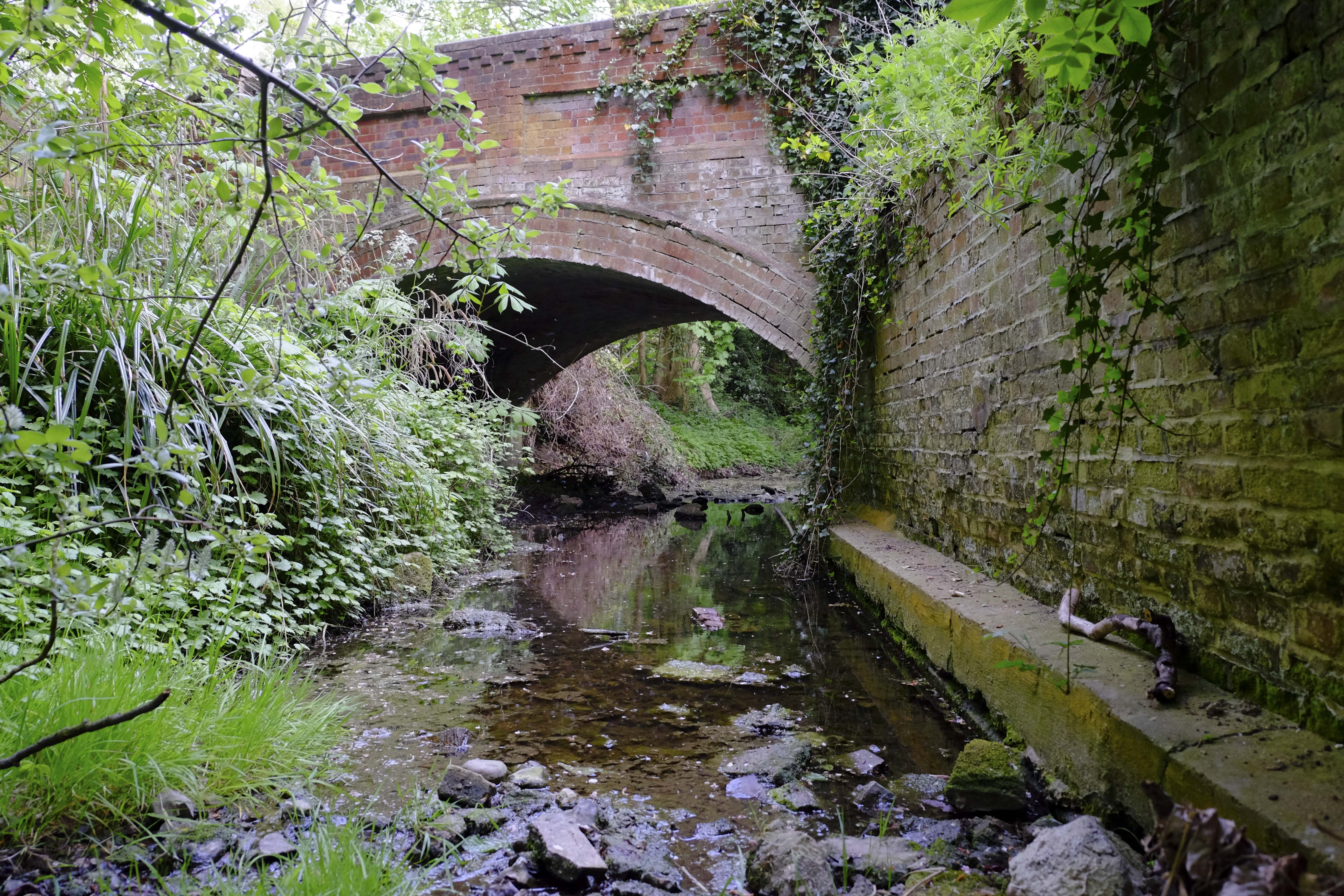
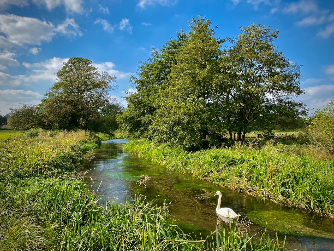
In May 2017 I took a tour through the Chilterns to take pictures of chalk streams which, although we were at the front end of a drought, should have been flowing and at their fullest for the year. In London’s orbit, chalk streams are still heavily abstracted, with abstraction rates in many catchments running at 20% – 60% of average catchment recharge. The coalition of NGOs on the CaBA chalk stream panel argues that A%R should be under 10% if flows are to get close to meeting their WFD targets.
For a look at our assessment of abstraction pressure as a % of catchment recharge on 55 chalk catchments look at pages 41/42 of the CaBA chalk stream restoration strategy ‘full report’ and also pages 14 / 15 of the ‘appendices’ on this LINK.
To view the full gallery of my pictures, click HERE.
River Rib, BuntingfordRiver Beane, High WoodRiver Quin, Little Hornmead BuryRiver Ver, Redbourn Gauging WeirRiver Chess, Chesham
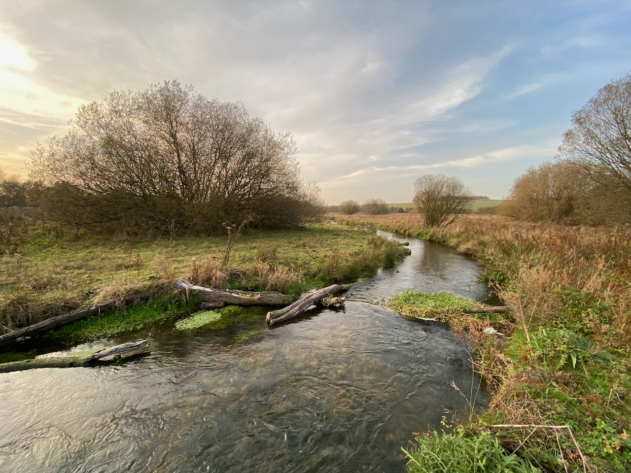
The timing was uncannily unfortunate. Last Friday – exactly one week ago – we launched the CaBA chalk stream restoration strategy – fruit of a year’s collaborative work between stakeholders, NGOs, government, water industry, farming and regulators – on the banks of the River Mimram. I had been determined to get the heads of the Environment Agency, Natural England and the Environment Minister Rebecca Pow into the river for a photo-call, as I believe when you immerse yourself in these wonderful ecosystems you become emotionally invested in them. I thought it would be symbolic in a small way. Binding, even.
The previous Saturday I had driven down to meet the farmer and owner of the venue and the river was looking great: good flows, clear water, billowing beds of starwort, the odd rising trout. I took this photo for the front cover of our flyer for the event.
The Mimram was a good place for the launch, I thought. It is something of a success story, in as much as we can find them nowadays. Fifteen odd years before, I had helped launch a WWF campaign there which we called Rivers on the Edge. I said to a crowd, which included local MP Oliver Heald, that chalk streams were our burning rainforest, our melting glacier and that we should fix the conservation crisis on our doorstep in order to maintain any credibility when addressing those crises in far-flung parts of the world. A metaphor that has since caught on, much as it was intended to.
The Mimram was under the severe pressure of over-abstraction in those days, but Oliver Heald – and others – have been stalwarts on its behalf. Abstraction at Fulling Mill was lessened in 2015, and ceased in 2017, although since 2019 the 9 Ml/d saving is split between Fulling Mill and Digswell. Now, it is within the target we set in our strategy, with less than a 10% impact at low flows. No bed of roses, mind. The Lea to the east suffers a 90% impact in the headwaters (which may affect the very upper Mimram) the Beane to the west, a 40% impact. There is still work to do: hence the event, hence the strategy.
The day went well. The vibe was energetic, positive, united, determined: but none of these in a naive sense. We were all frank about the scale of the task of fixing our beleaguered chalk streams. After the photo-call I took Rebecca Pow (Environment Minister) downstream so she could see a restoration project and a team at work in the river: Rob Mungovan, Wild Trout Trust project officer, accompanied the minister into the stream and effused about the underwater life and the power of habitat work to bring about change. We arranged to have a further meeting to go through all the report’s recommendations one by one. I got a sense of real commitment and though I know there are commentators out there who think I am hopelessly optimistic I will hold on to a belief in people’s desire and ability to make the world a better place until I’m six feet under.
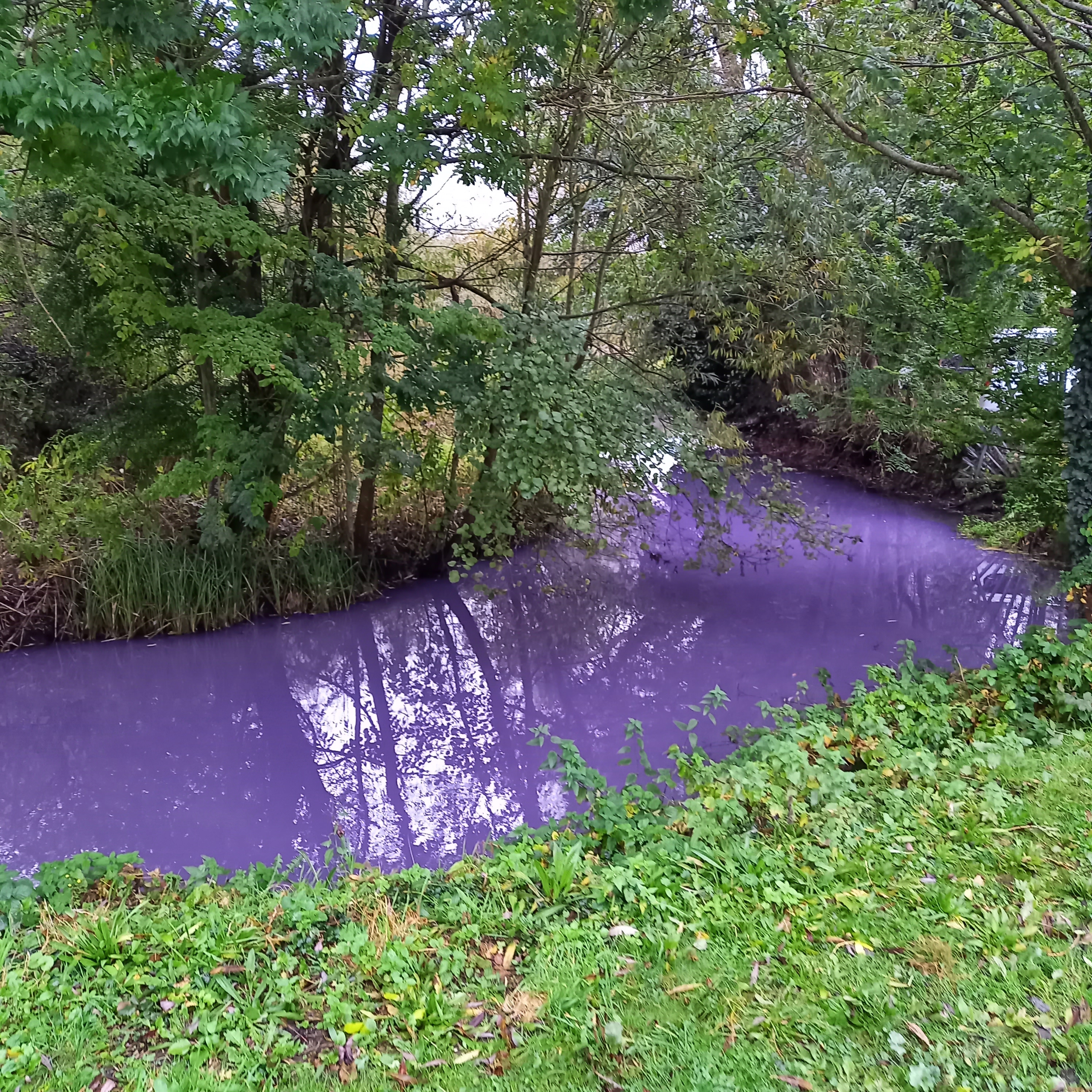
But then, as if to prove my hope and faith a vain conceit … on Monday afternoon like a scene from some kind of dystopian future inversion of everything we had been striving for, the river turned a vivid, hideous shade of purple.
Taken on Monday 18th October. Photo kindly supplied by the nice lady in the glass-blowing factory. Thank you.
I found out via a flurry of urgent emails on Tuesday.
The image had been posted on Twitter, alongside a picture of us posing in the river. My symbol of conviction had been turned on its head: “So much for fine words and speeches,” the post read, “all of it devoid of intent and delivering even less.”
Since I had delivered one of the speeches and the longest at that, I guess my words must have been included in that summary judgment: “devoid of intent and delivering even less”. Well, we should all be called to account, but I like to think I’ve done my bit for rivers since I first started a restoration project with school kids on a river in Dorset 30 years ago. As for delivery on this latest project, we’ll have to see, won’t we? I don’t think it will be easy, I don’t even think we’ll change everything we want to and need to, but giving it a weekend before condemnation seems a little harsh.
The reaction on Twitter was one of shock and anger. Too right, they chimed: this dystopian scene clearly displayed a cynical carelessness on the part of those great and the good pictured. How could these so-called custodians of the environment allow such a thing to happen on their watch? It was a disgrace, heartbreaking, beyond parody. Only one person from amidst the throng of commentators dared to point out that “not all pollution in water courses is from sewage works, and even if run well, and of appropriate capacity, they’re not a buffer against all kinds of stuff being dropped down the drain, they just can’t be”. Well, quite.
The river pictured was a deep and opaque purple from bank to bank: if you know anything about pollution, you’ll know that vivid purple is not the colour of a storm overflow and it’s not the colour of the unnaturally high phosphorus concentrations (invisible until they cause algal blooms) or sediment run-off that cause real, chronic ecological harm: the sorts of pollution that genuinely result from under-investment in sewage works or our careless use of the landscape are not quite so … theatrical.
This river, on the other hand, was purple, as in paint, or food dye, or the dye used to trace pipe outfalls and the like. It was odd, in other words. Dystopian, shocking, but also odd.
Bizarrely, no one on the Twitter feed questioned whether the EA had actually been notified, so that they might at least have a chance to investigate in a timely way. As it happened, the EA did visit on Monday – so they must have responded pretty quickly. The water had cleared by the time they got there: no dead fish, no dead invertebrates. Their notification of this on Twitter was greeted with incredulity and more abuse.
I also decided to go take a look myself. I wanted to know a bit more about whatever it was that had so undermined the intent I had invested in 12 months of working seven days a week: I deserved an answer, although I doubted I’d get one. I found the spot where the photo had been taken easily enough: a bend in the stream at the foot of the Mimram Road in Hertingford Bury, a cul-de-sac of industrial units. One of these units might have been uppermost in my list of suspects until I saw that the colour had obviously come from upstream of this point. A lady in a glass factory at the end of the road gave me the picture she had taken. The dye had come downstream quickly, she said, and dispersed quickly too: like a plug of vivid water, in other words. Someone had clearly chucked something into the river. Not so much a totem of cynical neglect by the regulators, then, as a totem of careless neglect by society.
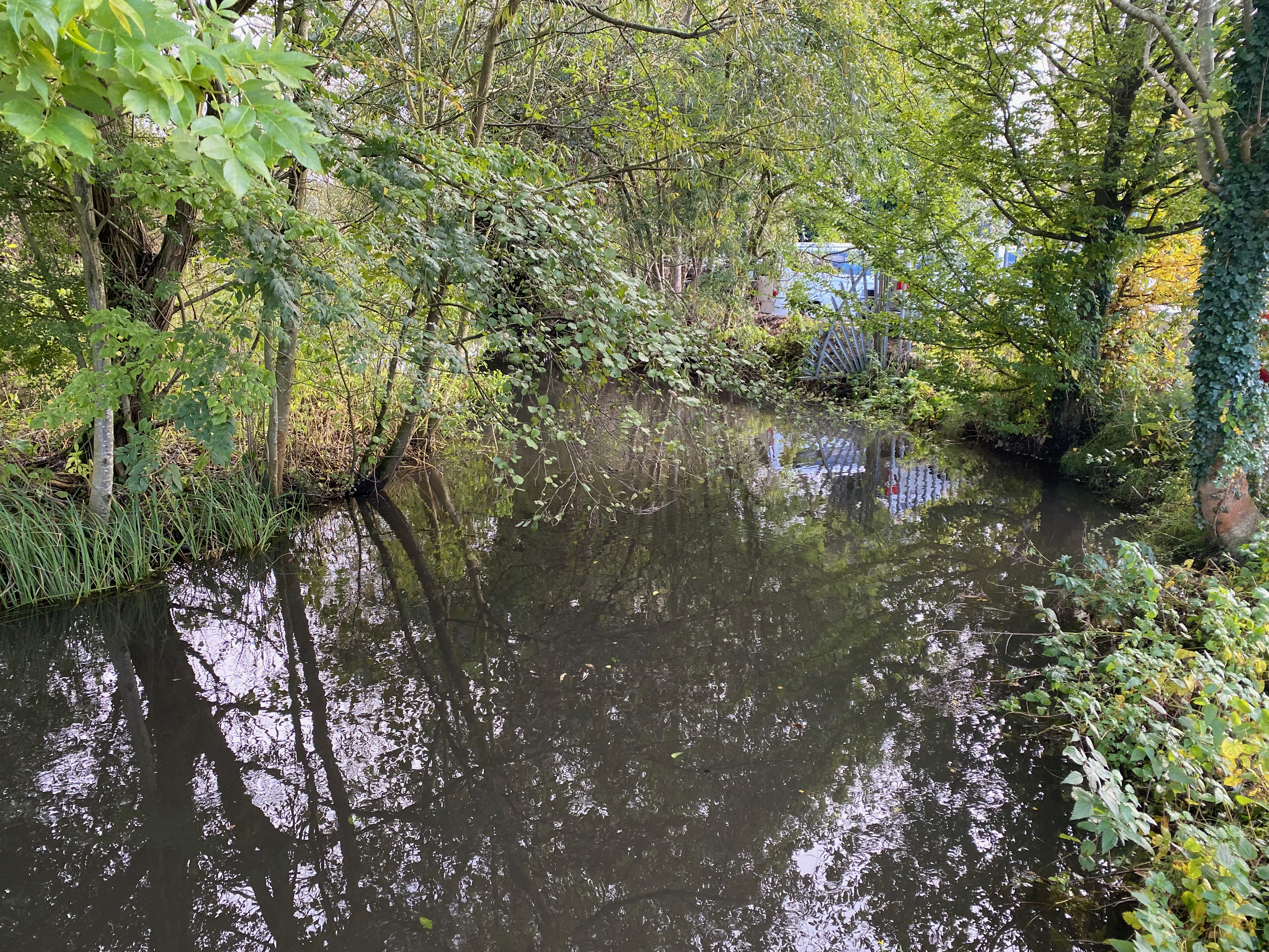
The same bend in the stream when I went on Wednesday 20th. This time carrying colour of a much more pernicious, but quotidian type: road run-off.
If it had come from upstream it hadn’t come far: Rob Mungovan confirmed to me that there had been no colour where he was working in Panshangar Park just upstream of the A414, less than a mile away.
In between, there are only a couple of places where someone could have tipped something in.
The first is where a footpath crosses the stream and although immediately below the A414, it is a long walk from any road. It would have taken a determined fly-tipper. I also noticed a road run-off discharge point there, under the flyover and draining the A414 above. I was there after a heavy downpour and although this was running, it was only a trickle. The part of the A414 that it drains is a deep puddle, and the drain is blocked with leaves. There was no pink residue there and anyway it would have been almost impossible to stop on the dual carriageway to discharge anything.
The second is the road bridge by the mill on St Mary’s Lane, just a hundred yards downstream from the flyover. You’d hardly notice the bridge unless you knew what you were looking for. I find it unlikely that anyone would stop there to chuck something in, but if they had the river is fast and turbulent at this point, so dye would have mixed well.
Between these two spots and the place the photo was taken there is no opportunity to access the river by the public. There’s just a pony ranch and open meadows and two small housing cul-de-sacs to the south of the Hertingfordbury Road, and a number of road drains that probably connect to the river. I didn’t have time to drive down either cut de sac, although I remember calling my wife at home and jokingly wondering if someone in one of those roads had new purple walls, but had bought too much paint, or a new purple hair-do but had bought too much dye. Either that or there are some pink ponies prancing about the meadows. Or it’s just a mystery and will remain one.
Oh the irony! Those great and good and their report which “says little and achieves even less” and as if to prove it, a vividly magenta river polluted by a mysterious dye that came and went and left no trace.
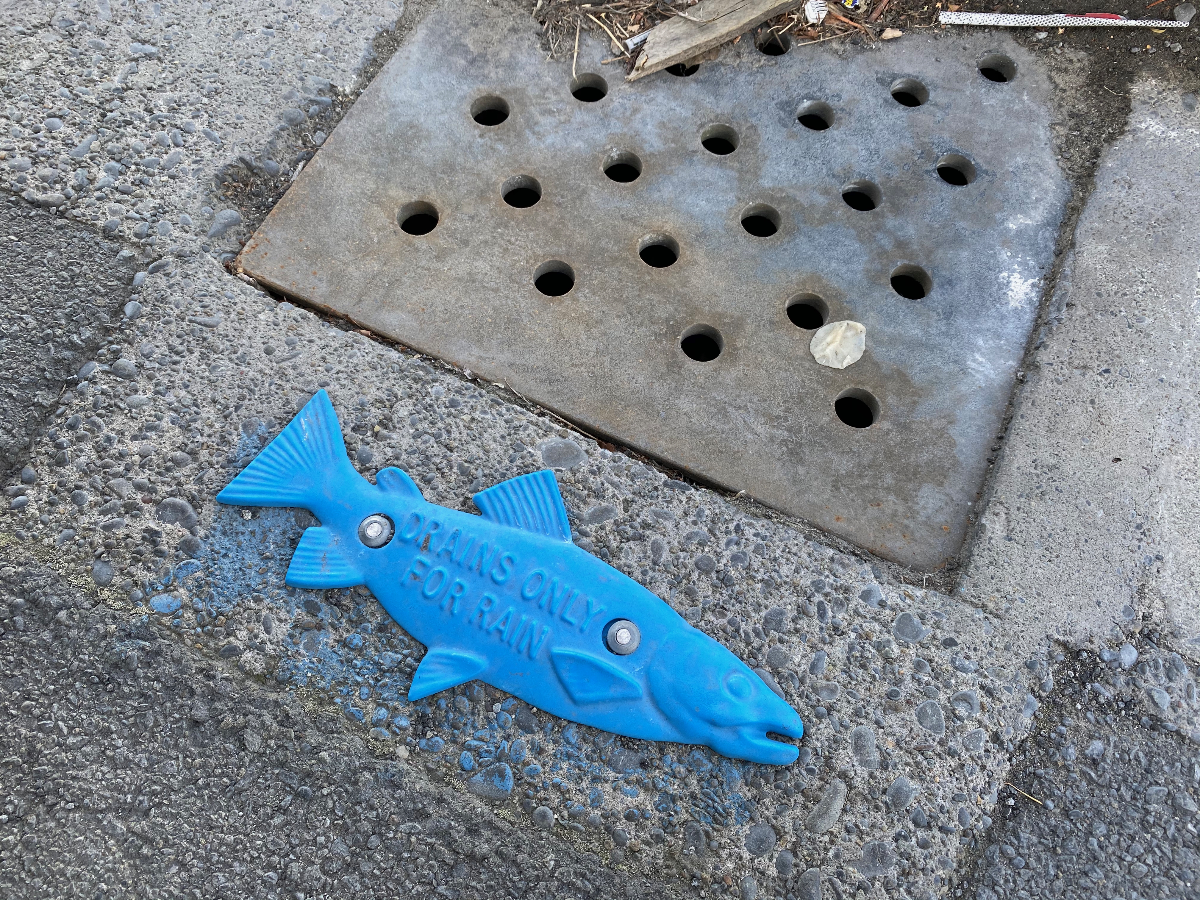
In Christchurch, New Zealand there are little metal fish-shaped plates pinned to the road by every drain, there to remind people that when you tip something down a drain, it ends up in a river. What this event really tells us is that we don’t care. We. Society. We don’t care. We chuck stuff down drains and don’t think about where it ends up or what it does. This time it was purple and apparently harmless and everyone noticed. Most of the time, no-one notices. And yet one drop of flea treatment on the back of a dog can kill all the insects in a long reach of river.
Meanwhile our chalk streams restoration strategy makes a number of strong recommendations endorsed by everyone involved, including the regulators and water industry, to reduce and eventually eliminate unsustainable abstraction (the definition of which is now agreed and meaningful), to reduce pollution in its various forms and to drive for physical habitat restoration. Some actions are already underway, the rest are being scoped and developed and will be outlined in an implementation plan this time next year.
There will be no Damascene moment on the road to restoring our chalk streams. To think there might be is naive. It has been and will remain an uphill struggle all the way, with progress made in incremental but important steps, collaboratively. As I said in my allegedly fine but empty speech: “you cannot fix rivers with words. You cannot fix them by insisting that someone else should fix them. You cannot fix them by the day after tomorrow. You cannot fix them if you haven’t worked out what’s wrong with them. You cannot fix them without working together – most likely with whoever, in your opinion, damaged the rivers in the first place. And you cannot fix them if you are not strategic about the way you do it.”
I was mortified to be nudged into realising that I hadn’t properly thanks and acknowledged the role of CRAG (the Chalk Rivers Action Group) and it’s chair Doug Kennedy in my speech last Friday as we launched the chalk stream restoration strategy. What a plonker I am.
To set the record straight: CRAG was formed following the Chiltern Society’s Chalk Streams In Crisis Conference in October 2019. The panel of speakers included Harvey Bradshaw (EA Director), Rachel Fletcher (OfWat CEO), Keith Gardner (Affinity Water), Yvette de Garis (Thames Water). They all agreed:
• that the Chilterns’ chalk streams are a rare and valuable landscape phenomenon, supporting rich ecologies in need of urgent action to restore water and aquatic life to their depleted riverbeds
• to work together to stop the loss of the Chiltern chalk streams, and to ensure that there are still chalk streams in a good condition for future generations
• to devote resources suited to the size of the task, including the time of personnel who have sufficient decision-making seniority to make a measurable positive difference.
Doug Kennedy conceived and directed the conference, under the auspices of the Chiltern Society.
The concept then was to form a group of senior personnel from the main bodies that have influence over the health of chalk streams who would work together to find real practical solutions to the ‘Chalk Streams Crisis’. Doug went so far as to deliver a letter by hand to Defra’s London offices and then met their dep. director of water.
Doug chaired CRAG’s first meeting on 3rd December 2019 which confirmed its priorities and way of working. During the following 11 months, the group met two further times and developed an Action Plan that was handed on to me at the virtual Chalk Streams Summit which took place on 16 October 2020.
Many people worked on and assisted CRAG’s progress and everyone agrees that the initiative moved matters forward, particularly regarding water company attitudes to the chalk streams and abstractions. Often accompanied by the tireless Feargal Sharkey, Doug met with Minister Rebecca Pow, Rachel Fletcher and many others to push the chalk streams agenda forward during 2020. The minister’s interest in chalk streams – which was made very clear to me when I met her last Friday – was definitely spurred on by Doug and his colleagues on CRAG.
It’s always important to acknowledge other people’s work and to be careful to properly share any credit that comes your way. People have been generous in saying “well done” to me and I wanted to make sure I shared that and extended it to everyone on the day of the launch. It’s a collective effort. But on this occasion the sheer weight of stuff in my head shoved an important piece of the early history off the edge of the cognitive bandwidth. Lots of people deserve thanks, but Doug and his Chilterns team got this ball rolling and history should record that.
My speech given at the launch of the CaBA chalk stream restoration strategy this morning, 15th October, 2021
I must start by saying thank you to all of you for coming along today to launch our chalk stream restoration strategy. We, the Chalk Stream Restoration Group, really appreciate your support. And of course, many of you have also been co-authors of this report. We have picked a lot of brains over the past year and processed a lot of feedback from all sorts of people. From those who are just passionate about their local streams and want to see them restored, to all sorts of experts in various fields. The quality of the feedback has been exceptional, whether it came via the online CaBA portal, or on the riverbank in August when we walked the River Nar and the River Itchen or via phone calls and emails over the past 12-months.
So, you have all contributed to this strategy and I like to think that it has been a democratic and inclusive work. I have certainly tried my best to listen and respond to anyone who has written to me: though I also know the sheer volume of correspondence – which is testament to how much people care – has rather overwhelmed my cognitive bandwidth and organisational skills on occasion. I may not have replied. Emails have piled up somewhat. If so, I’m really sorry for that. But I did listen and I did read them all. You are all co-authors and I’d like to thank you. I really have appreciated your interest and expertise.
I also owe more targeted thanks to those who sat on the panel meetings with me over the past year, who helped go over stuff again and again until we got it right. That wasn’t always easy, I can tell you.
I was lucky enough to assemble what probably started life as a Magnificent Seven but soon became an Oceans Thirteen of experts. Though they may be too modest to want me to name them, I will. I was able to draw on the invaluable expertise of:
Chris Mainstone, senior freshwater ecologist at Natural England,
David Sear, professor of physical geography at Southampton University,
Kate Heppell & Geraldine Wharton, both professors of physical geography Queen Mary University,
Steve Brooks, researcher in entomology at the Natural History Museum,
John Lawson, independent water-engineering consultant,
Tim Sykes, chalk stream expert researching the interactions between people and chalk streams PhD at Southampton University
Carl Sayer, Professor in Geography at University College London and passionate aquatic conservationist
Jonathan Fisher, independent environmental economist,
Alan Woods of the Cam Valley Forum
and Owen Turpin, sustainable abstraction manager at Environment Agency
And on the main CaBA panel I was fortunate enough to have the good company, can-do attitude and tireless enthusiasm of:
Sophie Broadfield and Affie Panayiotou, Defra
Anne Dacey, Environment Agency
Rose O’Neill & Charlotte Rose, Natural England
Fayza Benlamkadem & Magda Styles, Ofwat
Dave Tickner, WWF
Stuart Singleton-White, Angling Trust
Ali Morse, The Wildlife Trusts
Barry Bendall, Rivers Trust
Janina Gray, Salmon & Trout Conservation
Andy Thomas, Wild Trout Trust
Richard Aylard & Yvette de Garis, Thames Water
Jake Rigg, Affinity Water
Ian Colley, Wessex Water
James Wallace, Beaver Trust
Jake Fiennes, NFU
Numerous other Environment Agency and Natural England staff have also contributed their expertise with enthusiasm, as have representatives from the water companies covering chalk catchments. I have appreciated and relied on their knowledge and good sense and positive attitude. So, thank you.
Above all I relied on all of those things from Sarah Powell, operating as chalk stream manager at the Environment Agency. Sarah has been a pleasure to work with, to agree and to disagree with. Sarah never took it personally and was always gracious, even when I was picking away at things in a manner I suspect was really quite tiresome. She understood that I wouldn’t have been doing the job properly if I hadn’t been a bit dogged. Sarah put a hell of a lot into this report and deserves great credit, for her diplomacy, patience, pragmatism and knowledge and many, many hours of work, writing, fact-checking, proof-reading. Thanks Sarah. It’s been a real pleasure.
But Sarah is moving on as of next week, while the work of the CaBA group is just beginning. If I could take the chance to make a public plea: I very much hope that Sarah’s post will continue to exist and that we will continue to get the benefit of a full-time lead dedicated to chalk streams at the Environment Agency. It really matters.
***
Why? Because chalk streams are an exceptional type of spring-fed river distinct to England and parts of France and Denmark. Although chalk exists in other parts of the world, nowhere else do we find these clear-watered rivers we call chalk streams. In England they are distributed across an arc of chalk that runs from Dorset to Yorkshire. We are at the mid-point of the arc today, on the banks of one of Hertfordshire’s jewels, the River Mimram.
The Mimram – such a lovely name, it kind of sounds like a chalk stream doesn’t it? – is one of only 283 English chalk streams, counted alongside dozens of small, nameless scarp-face springs and rills, altogether comprising the majority of this type of river and freshwater habitat to be found anywhere in the world. They are our equivalent of the Great Barrier Reef or the Okavango Delta: a truly special natural heritage and a responsibility. Surely, if charity starts at home, then so does conservation.
Chalk streams – in their natural condition – are home to a profusion of life. When rain falls on chalk hills most of it soaks down into the body of the rock and there undergoes a kind of alchemy, emerging from springs as cool, alkaline, mineral-rich water, equable in flow: the perfect properties to create a richly diverse eco-system. Botanically, chalk streams are the most biodiverse of all English rivers. For invertebrates, fish, birds and mammals, they offer a vast range of habitat niches. In Wessex, they are a stronghold of our chalk-stream Atlantic salmon, now known to be genetically distinct. The upper ephemeral reaches, known as winterbournes, are global hotspots for a unique range of specialist plants and invertebrates.
But chalk streams are under immense pressure: they flow through one of the most urbanised, industrialised and populated parts of the UK. Three chalk streams flow through London and there are many more in the chalk hills that surround the capital. Further afield, though many flow through more open countryside, that countryside is busily farmed, while villages or towns are sited somewhere along most chalk rivers. All these streams are impacted in one way or another by the activities of people.
We depend on chalk streams for public water supply, and have leant heavily – in some places, very heavily – on the resources of the underground body of water that feeds these streams. And yet every litre of water we take out of the aquifers – and we take billions and billions of litres to irrigate our crops, or run our taps – is water lost to the natural environment. At least until we put it back.
Only, by the time we put it back, the water is rarely in the state in which we found it. And generally it has bypassed long reaches of the stream. It has passed through our sewage systems, becoming rich in nutrients and other pollutants. We may treat it, we may even treat it to a very high standard in some places, but in many others we do not. Routinely, we put back into these wonderful ecosystems, water which makes them eutrophic, so that oxygen is sucked away from the river life which depends on it.
Even the water which we do not take out, which actually makes it to the underground aquifer or the stream, is unnaturally changed by human activities. Our heavily farmed landscape exerts a huge pressure on water quality, either because rain runs off the land and along roads, accumulating harmful chemicals, nutrients and sediment along the way, or because it seeps down into the ground carrying with it the chemical fertilisers which have been applied to the land. There is now so much nitrogen in our chalk aquifers that we do not know how long it will take – even if we stopped applying nitrogen as fertiliser – for the aquifers to become clean again.
Finally, we have changed the rivers themselves, modifying them heavily over the centuries. We have used them for milling, for transport, to drive multiple agricultural and industrial revolutions.
More recently, in the post-war decades, we made one of the most drastic and permanent changes of all: we dredged them. We took out the gravel river-beds – on which almost all chalk-stream life depends – and dumped them on the banks, all in an ultimately misguided attempt to drain the landscape. The impact of this dredging is, even now, massively underestimated.
So, we have quite the job ahead of us if we are to leave our wonderful chalk streams in a better state than we found them.
But that is the challenge which this CaBA chalk stream restoration strategy has attempted to address – how to restore good ecological health to these unique rivers and the catchments which support them, all within the context of this busy landscape, occupied by millions of people going about their lives, with multiple stakeholders and competing demands on resources.
CaBA is a space in which all those stakeholders who are involved in the management, conservation and sustainable exploitation of our chalk streams can come together and try to agree on a way to achieve that goal. It is not always a comfortable space.
NGO’s have to be pragmatic.
Water companies have to be idealistic.
Agriculture has to adapt and be supported to do so.
Government has to listen and then act.
This restoration strategy is what has come out of that discussion: a strategic plan which, if followed, will allow us to become proud custodians of 283 ecologically vibrant chalk streams – streams that may once again flow with a healthy flush of clean water through meandering channels over bright gravel, full of wildlife, beside which it is a pleasure to spend time and which could and should be a credit to the stewardship of our generation.
A number of people have remarked to me on the sheer length of the strategy: 138 pages, plus appendices. They have a point. It is long. But, don’t worry, I still have my first draft which was only nine words and written on the back of an envelope. It reads, simply …
More water.
Less pollution.
More gravel, gradient and trees.
That’s it. I wrote the strategy months ago. All the rest of those 138 pages is just an analysis of how to make those things actually happen. It’s not complicated.
Except that it is. For two reasons.
The first is cost. More water costs money. Less pollution costs money. And more gravel, gradient and trees costs money. It all costs money.
The second reason it gets complicated derives from the first: because these things cost money, we have trouble agreeing which is the more important, which improvement will yield the greatest ecological gain, per se, but more than that, which will yield the greatest gain for the least cost.
My thought, and I’ve been thinking about it now for over a year, is that this is where we have become stuck. Round and round we go, looking for single-cause evidence that simply doesn’t exist in the unambiguous form our economic models demand.
Of course, working cost-effectively, addressing problems in the correct order, is a perfectly reasonable way to proceed. But ascribing and proving ecological damage to one cause, in order to justify the cost of redressing that damage via addressing that one cause is a road to nowhere.
In a given catchment the links between cause and effect are so complex that any attempt to prove a causal link between improvements in one area (flow, say) and overall ecological improvement, is almost doomed to yield inconclusive answers. And therefore it is doomed to yield inaction.
So, what we have tried to do, above all with this strategy, is illumnate the links between the components of ecological health in order to rebalance that burden of proof, and justify making all these improvements together in a joined up and strategic way. Because that is the way to make sure the money is well spent and that is the way to bring back wildlife. We’ve got to get away from the siloed, timid, piecemeal and reach-based restorations and think on a different scale in a much more strategic and connected way.
That is why this plan addresses all three parts of that envelope haiku in turn and all three in combination under the titles:
• water quantity (the naturalness of the flow regime)
• water quality (how clean the water is)
• physical habitat quality (the physical shape of the river, but incorporating biological factors like invasive species which can degrade habitat directly and indirectly)
We look at these elements singly because it helps to focus, but in combination too, because it is important to remember how each one either positively – or negatively – affects the others.
Re-naturalising flow will improve river health by improving water quality (its chemistry, cleanliness and temperature) and physical habitat (volume, speed of flow). But the benefit of re-naturalising flow is greatly increased if water quality and physical habitat are improved at the same time.
Improving water quality or physical habitat will likewise enhance the health of the chalk stream although not as much as when flow is also re-naturalised, at the same time.
Therefore, the best restoration strategy for any river will address all three together: renaturalising flow and improving water quality while using landscape-scale physical-habitat improvements to consolidate the beneficial impacts of all three and thus deliver maximum ecological improvement.
Combining all three will achieve this outcome miles more effectively than when the elements are only improved in isolation, or a bit here and a bit there while we wait for signs that what we’ve done has achieved something.
Of all recommendations we have made, the overarching one is for a form of statutory protection that will drive investment and allow us to work in the way I have just described. Over and over, while preparing this report, it has been made clear that when it comes to the investment decisions which determine the health of our chalk streams – in reducing abstraction, or pollution or paying for habitat work – a powerful statutory driver would make all the difference. A statutory driver would allow the regulators, industry and NGOs to do what they need to do to bring our chalk streams back to ecological health, not just in a few privileged places, but right across the map.
An awful lot of the rest would flow (no pun intended) from that.
Elsewhere we have recommended a review of cost-benefit analysis to take the brakes off investment in abstraction reductions and water treatment in chalk streams, to ensure the water company customer surveys communicate the importance of these iconic habitats to the public.
We have a sensible and pragmatic consensus agreement on what we mean by sustainable abstraction and have made a clear recommendation to water companies, government and regulators to set time-bound goals to meet this target on chalk streams, prioritising headwaters and working on a regional scale.
This is very much the message we have sent through to the national framework for water resources planning, and I know that water resources east and south east are both engaged in very serious analysis of how to address the flow deficits in chalk streams. I also know that the numbers being discussed are genuinely convincing assessments of the degree to which our chalk streams are over abstracted.
We have recommended a review of waterbody boundaries and assessment points to ensure that methodologies for assessing flows and water quality protect all of the chalk stream reaches and especially their headwaters
We have recommended the prioritisation of investment in both abstraction reduction and water treatment from the headwaters downstream. In fact, the headwaters first principle runs loud and clear throughout this report: get things right in the headwaters and the benefits wash down – quite literally – throughout the system. In the past, cost benefit weightings have tended to favour the lower reaches.
We have recommended the designation of all chalk-stream regions where public water supply is heavily reliant on groundwater abstraction as ‘water-stressed’, enabling greater protection in these areas, including metering. I’m happy to say, that that designation has already been delivered.
We have recommended multiple actions to drive down the nutrient loading of chalk streams to ecologically appropriate levels, including: a prioritisation of investment in all sewage-treatment works contributing to WFD nutrient failures; a reduction in the frequency and duration of storm overflows spilling to chalk streams; a suite of practical farming rules for chalk-stream catchments designed to limit pathways of diffuse agricultural pollution from landscape to river, with farm payment contingent on compliance and backed up by strict enforcement.
We have given a loud and clear endorsement to the use of new Nature Recovery Network (NRN) and Environmental Land Management (ELM) schemes to deliver landscape-scale biodiversity gains in chalk catchments.
And we have already started planning a national network of flagship full-catchment restorations where all parties in the CaBA partnership will cooperate to enact all aspects of the restoration strategy – addressing flow, pollution and physical habitat in unison.
These recommendations represent a broad consensus among the working group of the nature and scale of the threats and problems and of the necessary solutions. Where they are within the gift of the working group, progress is already underway. Otherwise, recommendations are now in a scoping phase and will be reviewed by various lead partners and planned over the following months. An implementation plan will be published in October 2022.
***
I’ve spent a lot of time in rivers trying to fix them. If that has given me any insight at all, it is that you cannot fix them with words. You cannot fix them by insisting that someone else should fix them. You cannot fix them by the day after tomorrow. You cannot fix them if you haven’t worked out what’s wrong with them. You cannot fix them without collaborating – most likely with whoever, in your opinion, damaged the river in the first place. And you cannot fix them if you are not strategic about the way you do it.
The Government’s stated ambition in the 25-year Environment Plan is to “leave the environment in a better state than we found it”.
We can only do that for our chalk streams if our regulators, the water industry, farmers and landowners, and all quarters of the NGO conservation sector work together, break down the journey into assailable tasks, simply expressed, tasks that everyone can agree on and commit to.
Then we need to be strategic about the order in which we do things.
Prioritise by identifying significant, realisable goals and then go ahead and realise them.
We’re not going to put all our chalk streams back into excellent ecological health by next year, or the year after or even within five years or ten.
But we could put some of them back into excellent ecological health within that time.
And then year by year, decade by decade, if we commit to the tasks in our strategy and if we actually realise them one by one, we will be able to look back at how far we’ve come and then forward again with renewed energy for the tasks that remain.
I have been invited to talk to the Cam Valley Forum on the 25th March about all things chalk stream but particularly about the chalk stream restoration strategy I have been helping to develop with our CaBA Chalk Streams Restoration Group. The talk is an open forum and you can book your ‘virtual’ place by following the link in the invitation below from Alan Woods the Forum Hon secretary.
(The picture above is of the Mel, one of a chain of lovely little chalk streams that rise along the edge of the chalk downs between Cambridge and Royston.)
“Dear friend
Please find attached an invitation to our Annual Talk, which will follow the Cam Valley Forum’s AGM on Thursday 25 March.
This year’s talk is being given by Charles Rangeley-Wilson, Chairman of the National Chalk Stream Restoration Group. Charles is a leading environmentalist and advocate for Chalk streams. This meeting will provide an early opportunity to hear about his expert Group’s draft national plan to restore Chalk streams.
His Group’s proposals are expected to be ambitious and far-reaching and will be highly relevant to our own Chalk streams in the Cam Valley.
Timely, given the beaver controversy, that I had actually spent a few hours on Friday drawing aerial diagrams of my recent river project to animate a presentation I’m planning on the possibilities of ambitious chalk river restoration.
This project is the latest phase of a piece-by-piece catchment restoration of the River Nar, funded this time by a Water Environment Grant and managed by myself as designer and the Norfolk Rivers Drainage Board as project facilitators (they did all the difficult stuff like Health and Safety, managing the finances etc.) particularly Paul George, Helen Mandley and Caroline Laburne.
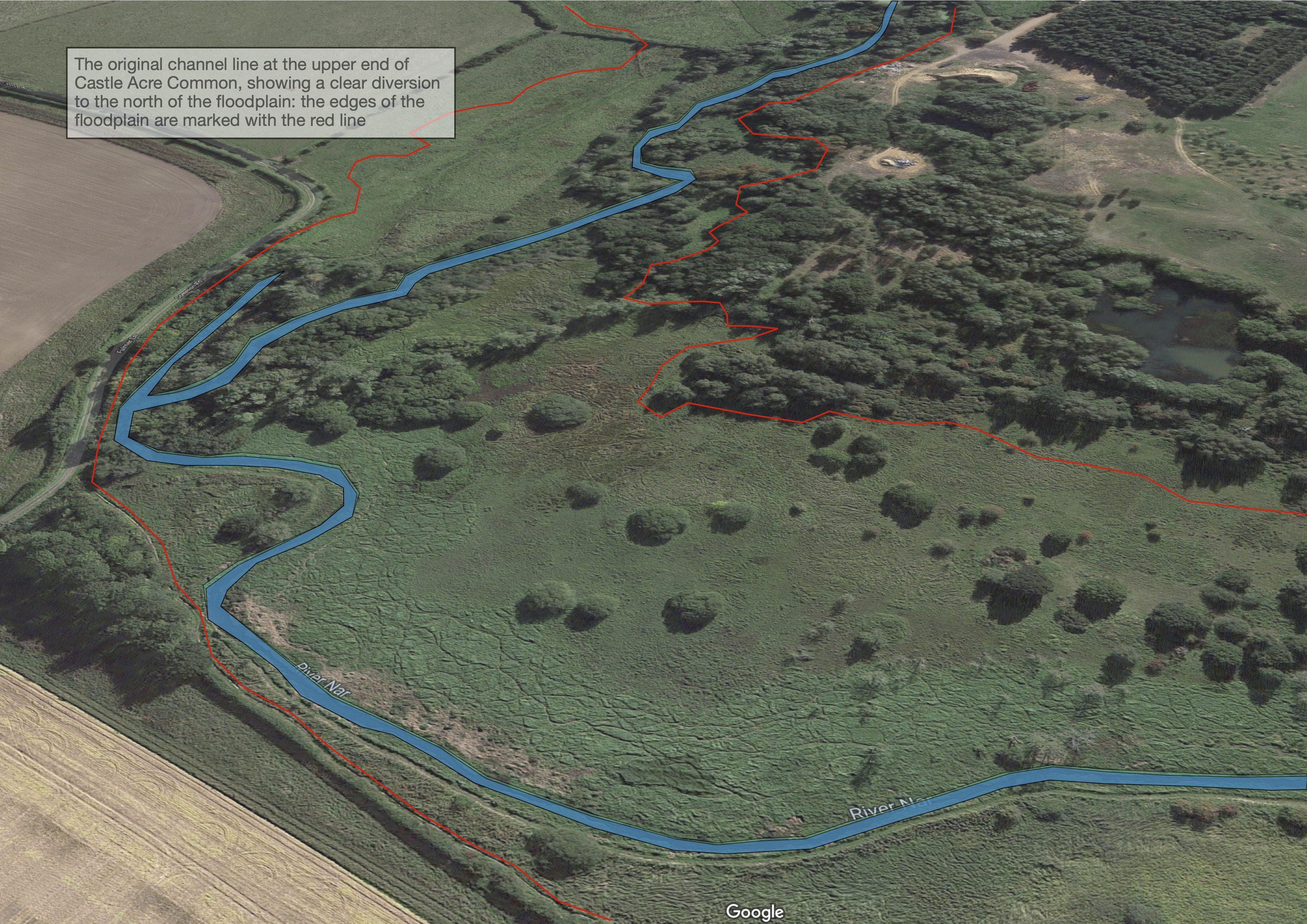
The primary driver was the creation of hydrological or lateral connectivity around a part of the river that had historically been diverted to the edge of the floodplain to build up a head of water to drive a mill. This type of channel diversion is very common on chalk streams, but it has the effect of divorcing the river from the floodplain, and lowering the gradient over long reaches in order to build up the head at the mill. More or less universally this creates a sediment retention issue, especially nowadays that the mills are not worked.
Add late 20th century dredging or zealous weed management to the mix and you end up with a channel that flows slowly, is full of sediment and burr-reed, cannot scour itself clean and is disconnected from the floodplain.
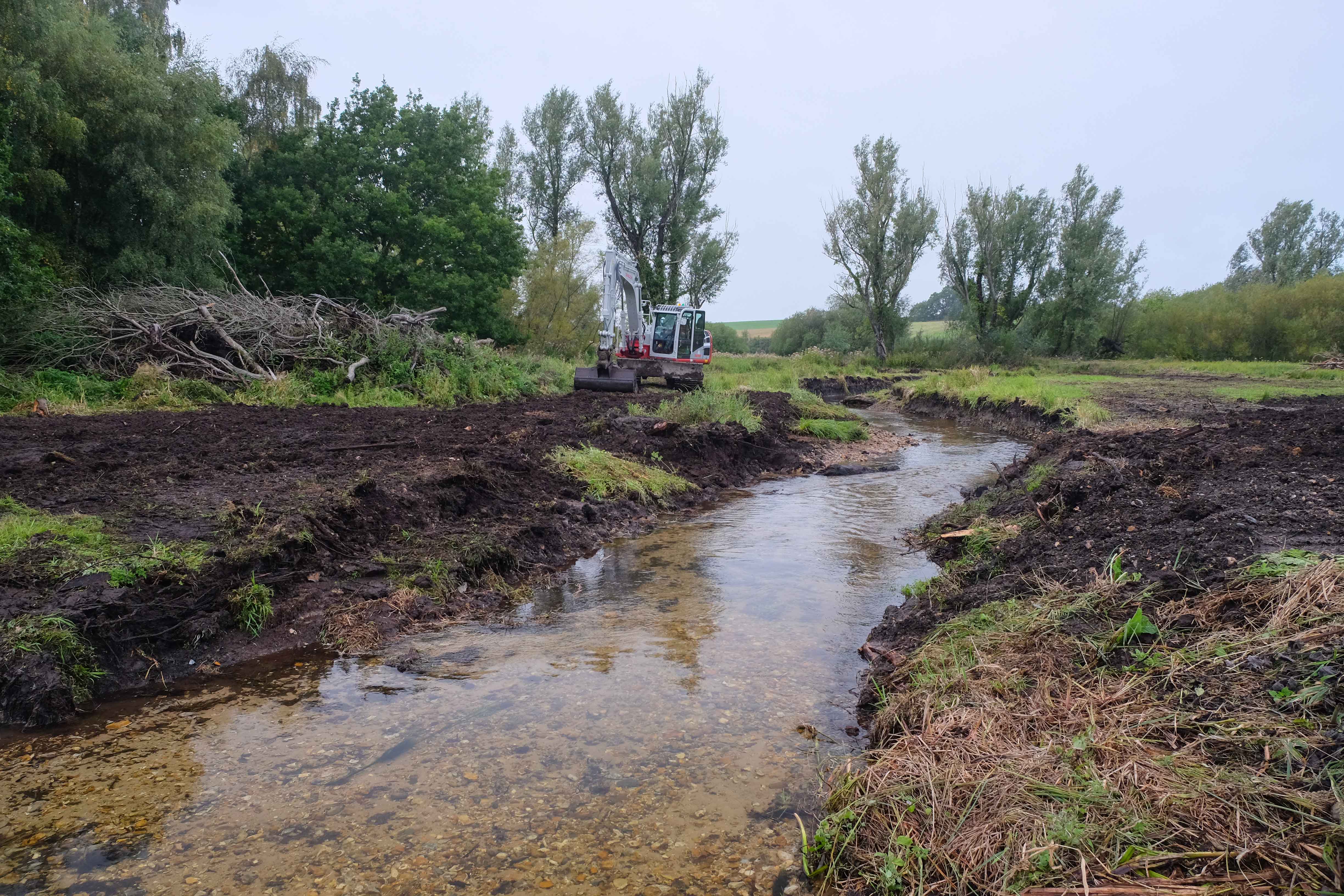
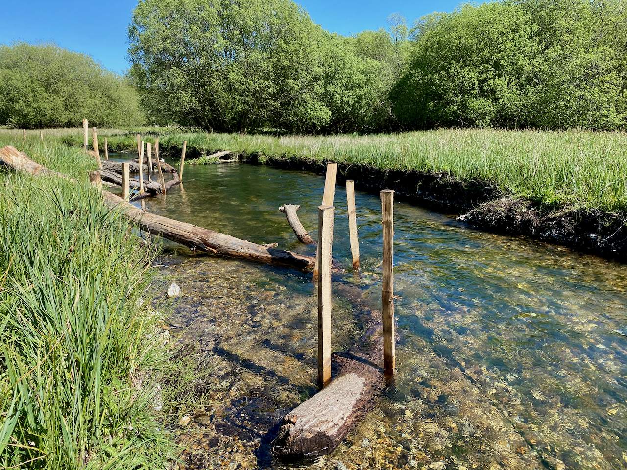
The drawings below show Phase 1, the uppermost part, which we carried out in late 2019. We finished Phase 2 in autumn 2020. We came in under budget, so hopefully now there will be a Phase 3.
The top diagram shows the river before the works, the red lines marking the edge of the floodplain. You can see how the river has been diverted to the very edge of the northern (left) part of the floodpain. With the river thus diverted and also overdeep as a result of dredging, the option to restore the gravel bed of the river in situ would have been enormously expensive, unsustainable and not ideal anyway, given that the channel was kind of in the wrong place.
I designed a new channel planform flowing roughly where the river would once have been (the very upper hundred yards actually cuts a corner, but it does that because only at that point could I come off an undamaged part of the original channel bed and start with a good baseline level). I based the meander shapes on field measurements of as many local original meanders as I could, including some lost original meanders.
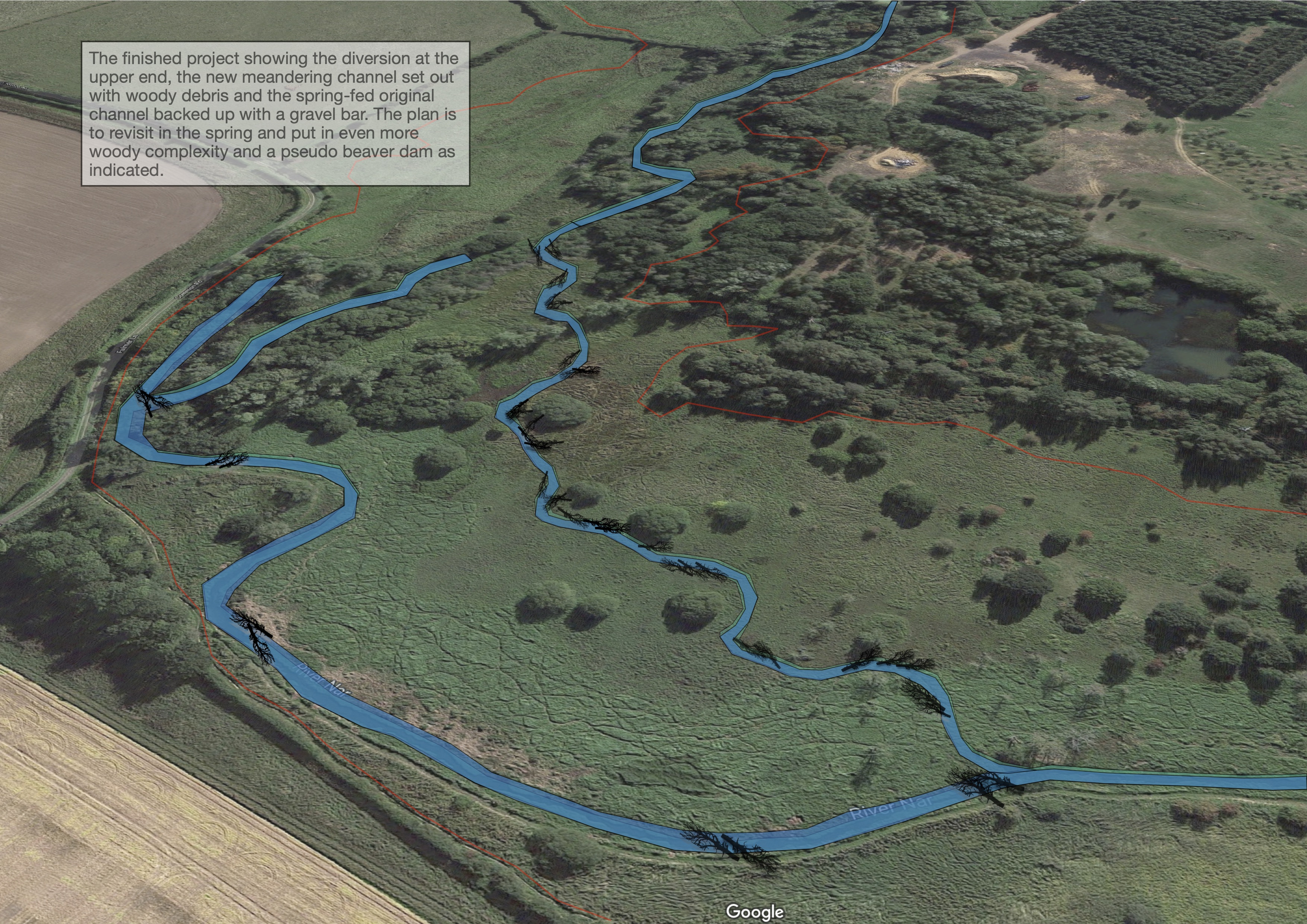
I calculated the gradient from the very uppermost point to the return point which would be 2000 meters downstream. This phase illustrated is about 450 metres. Based on the number of meanders at the estimated wavelength I ended up with a fairly easy to measure 5cm fall from one inflection point to the next. Between these we cut the bends about 30 cm deeper on the outside below the undercut bank. We also ended up with piles of gravel here and there from the channel excavation and these we tossed back in at the end to give the river some grit to work with.
Look carefully at the diagram and you’ll see we only cut off the top fifty yards of the old channel. It still has flow: it is spring-fed from groundwater seepage and some quite significant springs at the corner. So, to add to the channel types and biodiversity of the floodplain as a whole, we put a high bar of gravel just upstream of where the new channel runs back in: this has backed up the water in the old channel and created a more fen-like habitat, or pseudo oxbow.
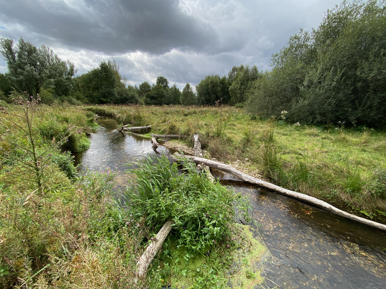
Finally, a few months after it had all settled in we pinned a very large number of trees and branches to the new river bed: not as many as I would have liked to, now I go back and take a look. I plan to do more in the new channel and the old, to get as much complexity in there as possible and in the old channel to pack it out and saturate the floodplain.
Early results from invert and fish surveys courtesy of the Norfolk Rivers Trust look really good: a healthy size range of trout (lots of juveniles and a few old snorters) and good invert numbers and diversity.
I’ll write about the next phase in the next blog post, when the overall design will be made clearer, especially why we had to run this to phase back into the old channel. In the next phase we end up with three channels side by side and some pseudo beaver ponds too. And a short “Stage Zero”.
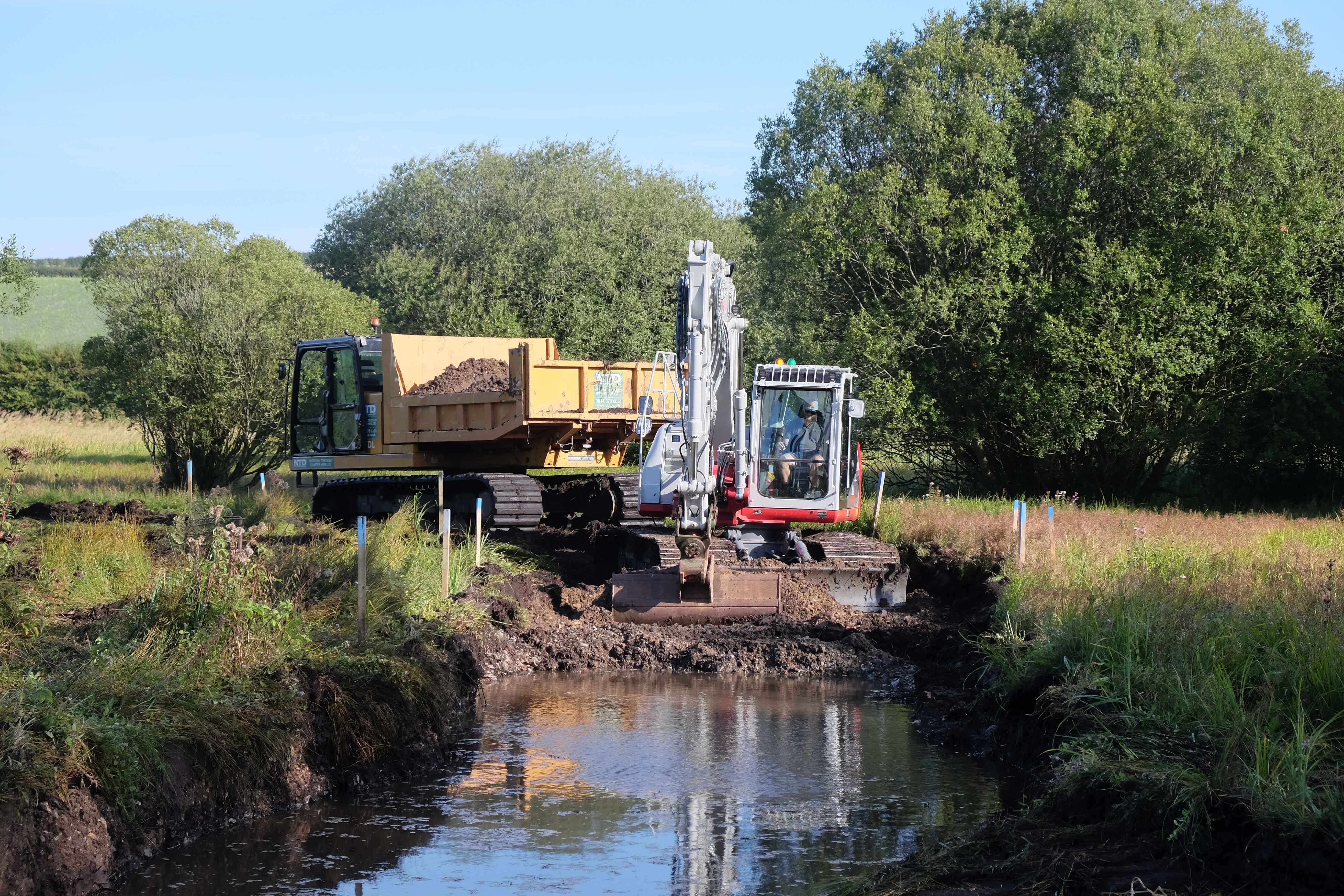
The pictures below the diagrams probably say more than lengthy explanations can.
The first cut.
A dumper followed the line of the emerging channel and took the spoil off site to fill in an old, dry quarry pit.
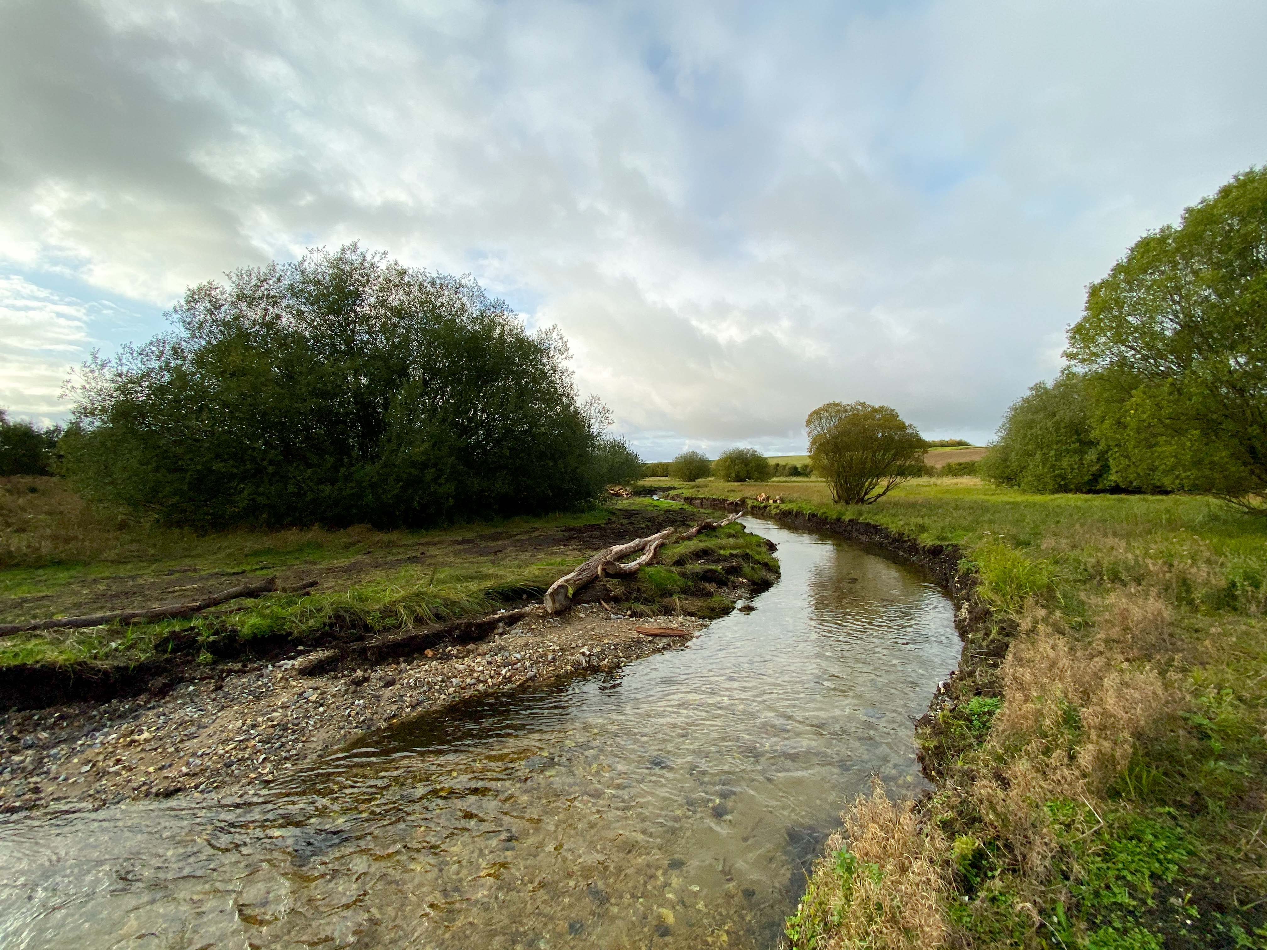
The sequence above shows the same bend as it is cut, then in the autumn 2019 just after the works had finished (top right) spring 2020 (next one down) summer 2020 (bottom left) and one year on, autumn 2020 (bottom right).
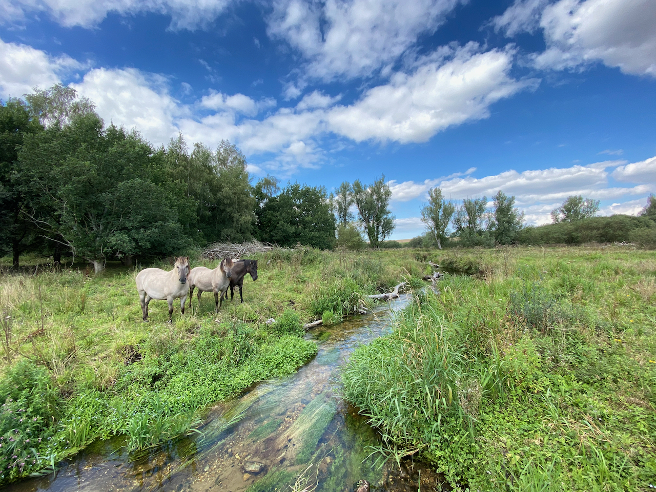
The sequence above also shows several shots of the same reach, just as we are tidying up (autumn 2019) (note the pile of LWD ready to go in), summer 2020 (bottom left) (we have Konik ponies to help manage the floodplain), autumn 2020 (middle right) and under high flows winter 2020.
LWD being distributed along the river bank as the machinery leaves the site.
Pinning the LWD into place the following spring.
Mid-summer 2020 and the channel is starting to look like it belongs there.
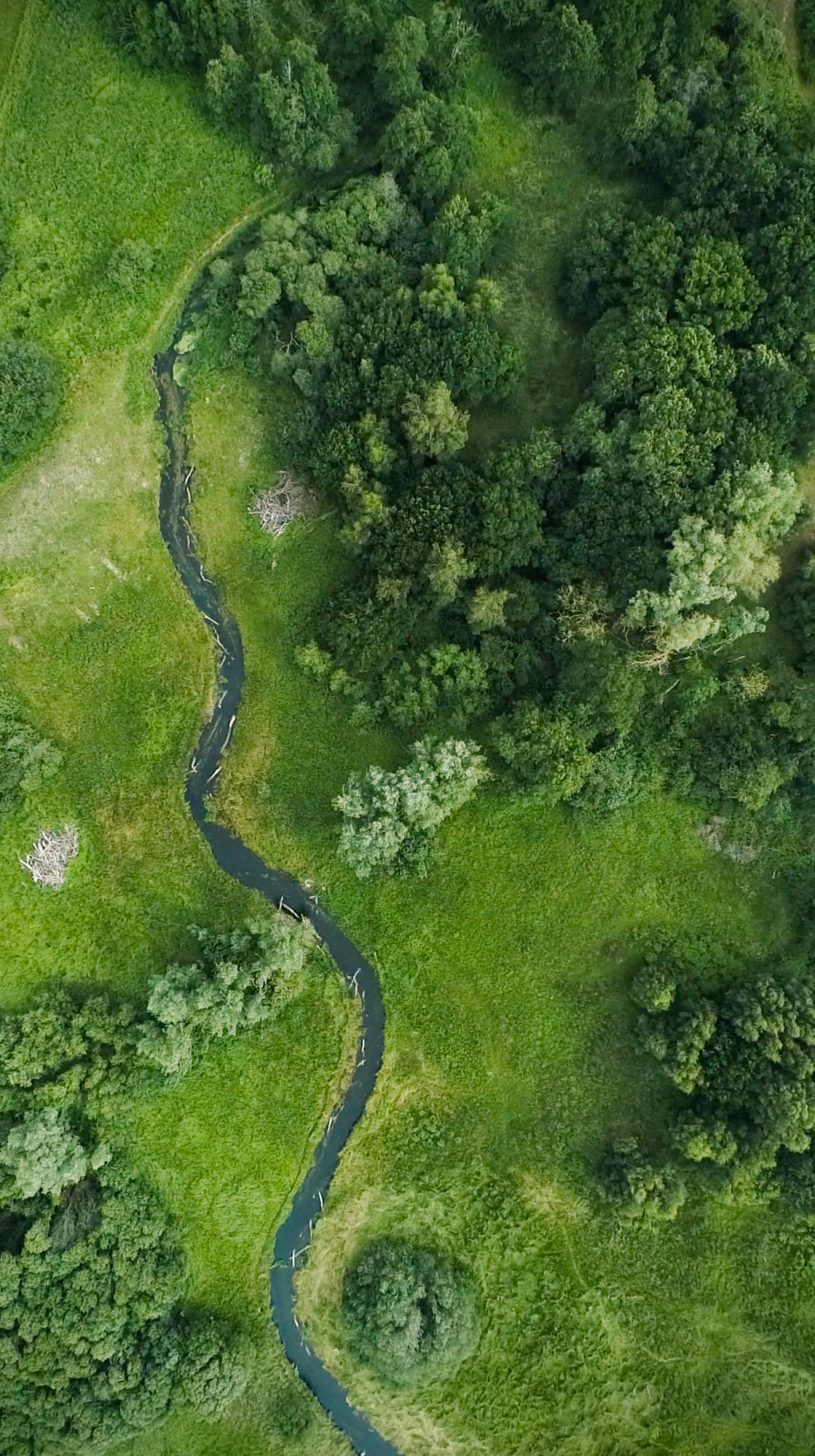
Aerial photo of the new channel stitched out with LWD. The take-off point / old river is the very light patch to the left of the channel at the top of the image.
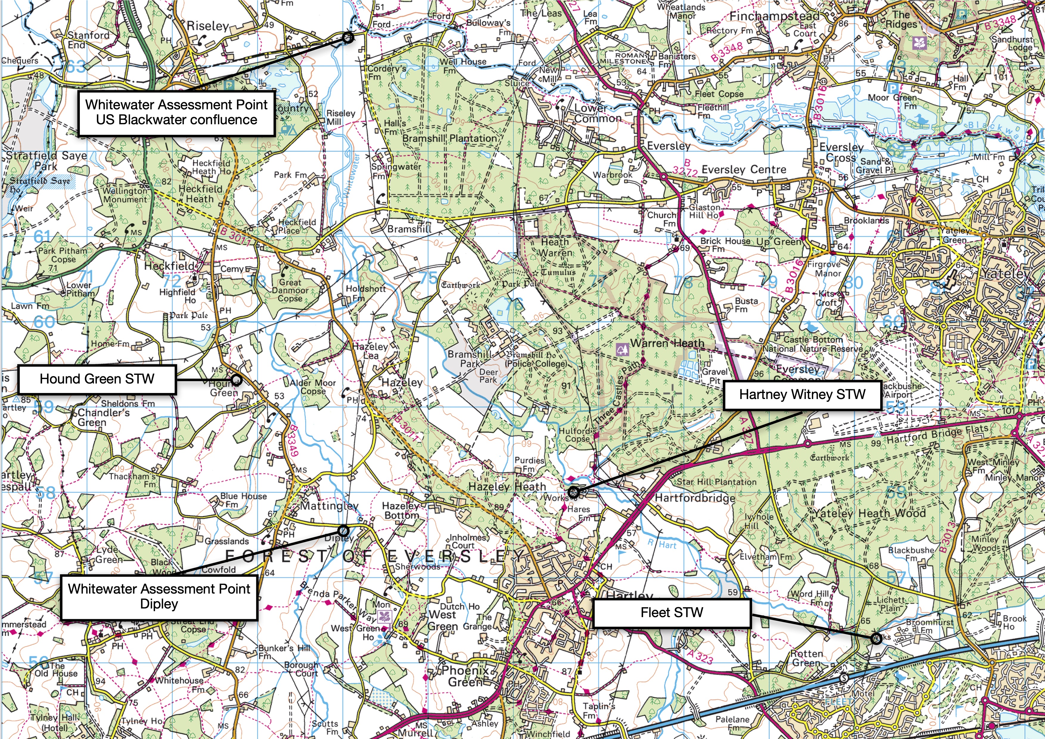
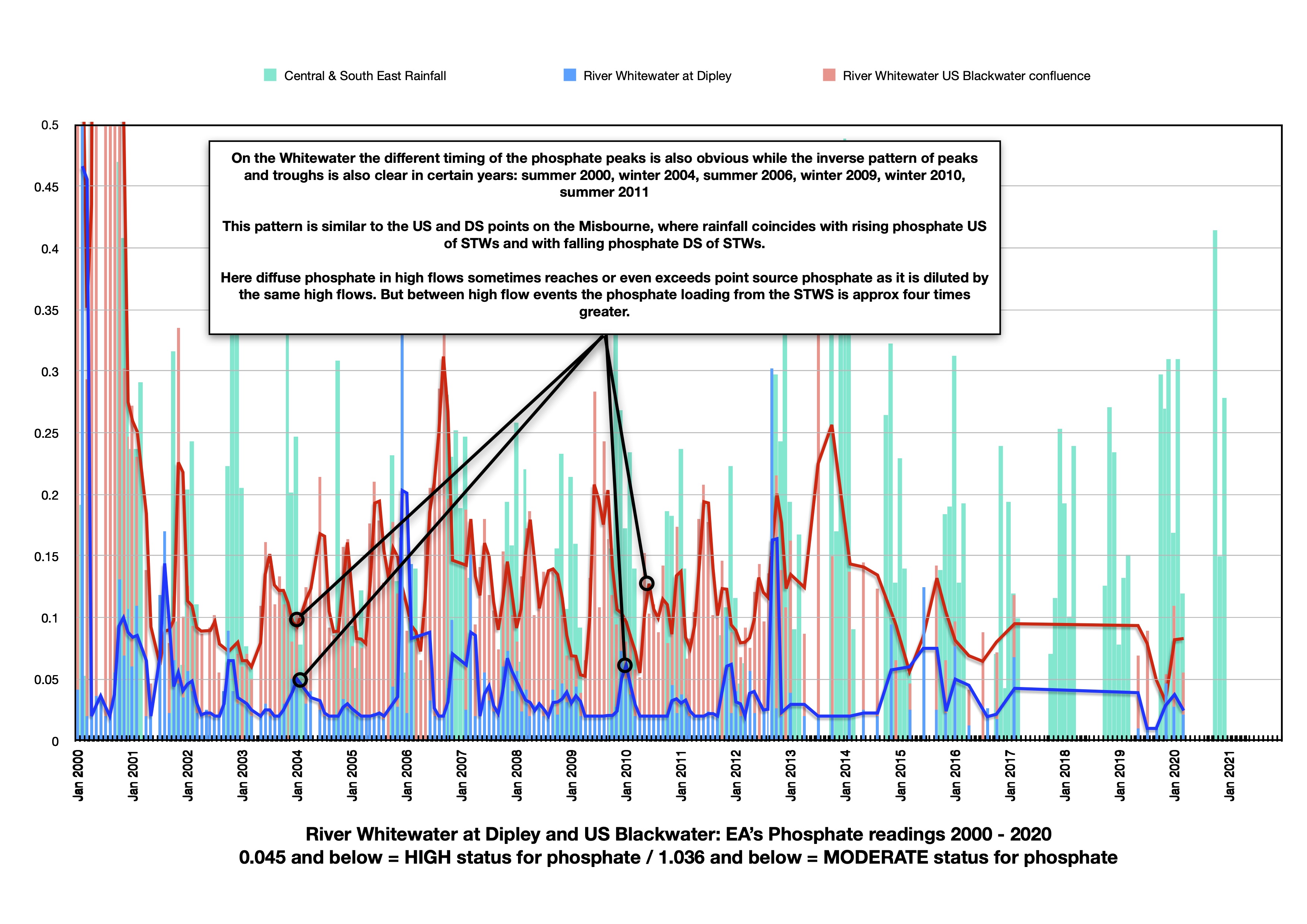
And here is a chart for the Whitewater in Hampshire, a chalk stream rated as Good for Phosphate. But that “Good” is an average. In fact the river is at High status upstream at Dipley and Moderate status downstream at the Devil’s highway just upstream of the Blackwater confluence. In between lie three sewage treatment works (STWs), two of which do strip phosphate, albeit but they are largish works at Hartney Witney and Fleet. The third works at Hounds Green, I’m not so sure, but I suspect it is too small to get phosphate removal.
The River Whitewater in Hampshire shows a less extreme but in some ways clearer version of the pattern on the Misbourne … see earlier post. There are numerous small discharges upstreams of Dipley, but no sewage treatment works.
The lower Assessment Point near the Blackwater confluence is impacted by three STWs, Fleet and Hartney Witney via a tributary called the River Hart and also Hound Green.
The phosphate peaks upstream at Dipley tend to coincide with or even follow winter rainfall, while the phosphate peaks downstream quite clearly coincide with late summer and precede autumn / winter rain. The peaks and troughs are in a clear inverse pattern
Note how the peak loading from the diffuse / disparate sources at Dipley matches the downstream readings as the point sources become diluted by the same high flows, but that between high flows the readings downstream are approx four times greater.
I’ve been putting together a few more graphs to try to understand a bit more about the relative impact of small sewage treatment works on Cinderella chalk streams: by that I mean the chalk streams not protected by either SAC or SSSI designation or the Urban Waste Water Treatment Directive.
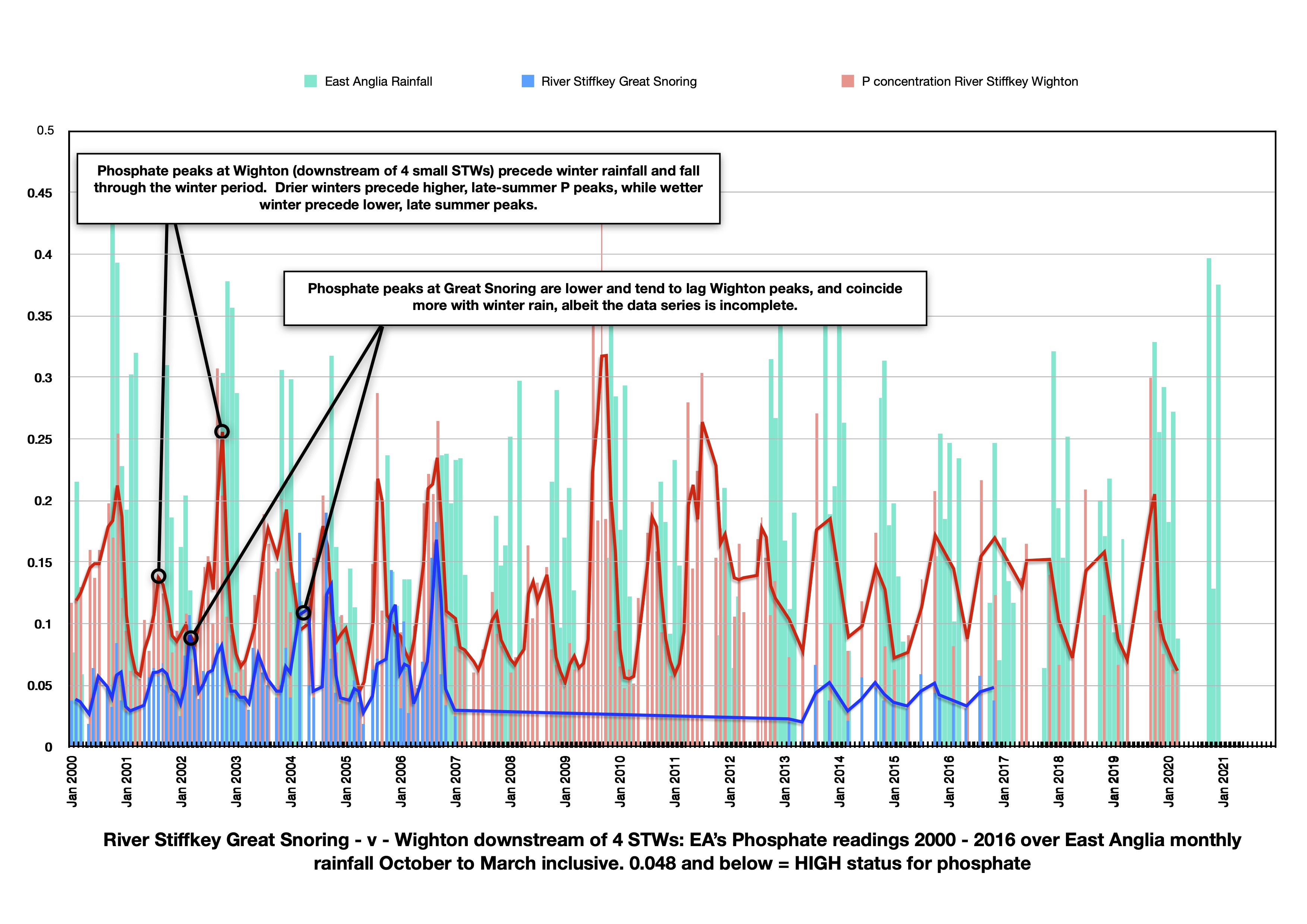
The first chart shows the River Stiffkey, a small stream in my home county of Norfolk.
This data is taken from EA monthly readings, although as you can see the readings are not at all monthly (each vertical red or blue line is a reading / the tracker line is the rolling average). They are inconsistent and the data series vanishes here and there, which is a great shame. Nevertheless a picture emerges.
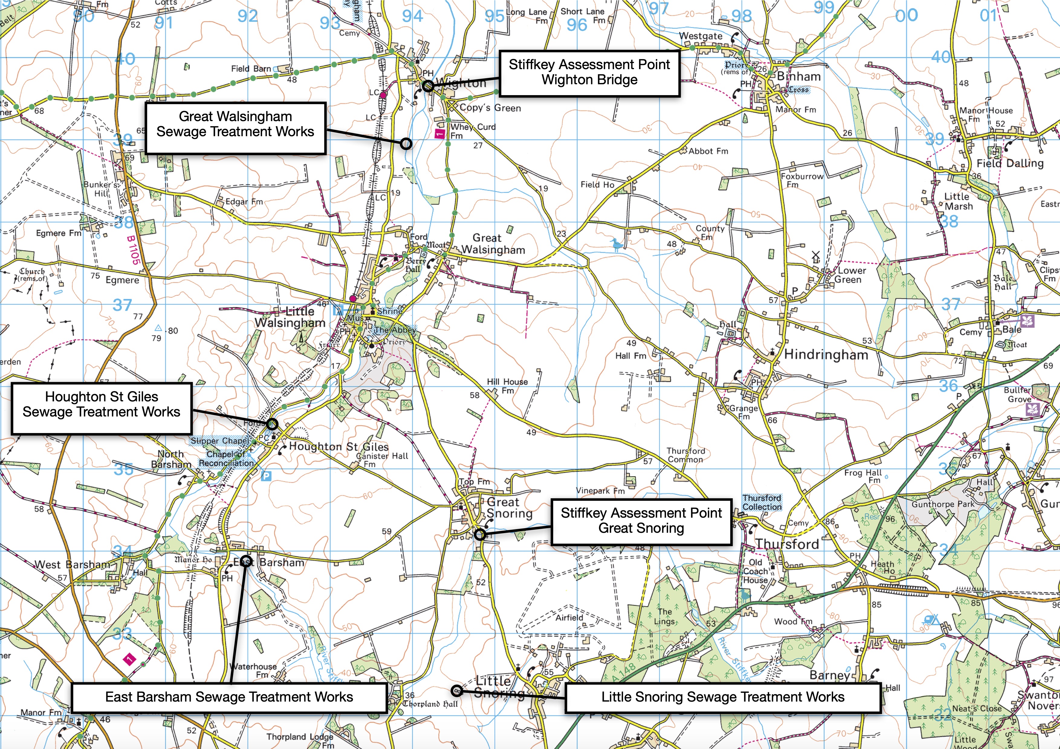
The chart for the upper River Stiffkey compares readings in the upper river at Great Snoring, with readings a few miles downstream at Wighton. Between the two Assessment Points there are four small STWs – Little Snoring, East Barsham, Houghton St Giles and Great Walsingham.
The Great Snoring data is inconsistent, but it is nevertheless clear that upstream readings are considerably lower and that the difference is more obviously attributable to P discharges from the STWs: the upstream spikes lag behind those downstream and coincide with winter rain. The downstream spikes rise through the summer when the difference between the two is at its greatest. A slight exception is late 2007, a very wet early autumn which followed a dry winter, which could explain high late summer levels from point-source discharges, immediately followed by high early autumn levels driven by diffuse run-off. Unfortunately the Great Snoring readings stop mid-winter 2007 and so the blue line tails off when it might actually have continued to be high.
The cumulative impact of four small sewage treatment works, none large enough to merit the investment of phosphate stripping, is only too obvious.
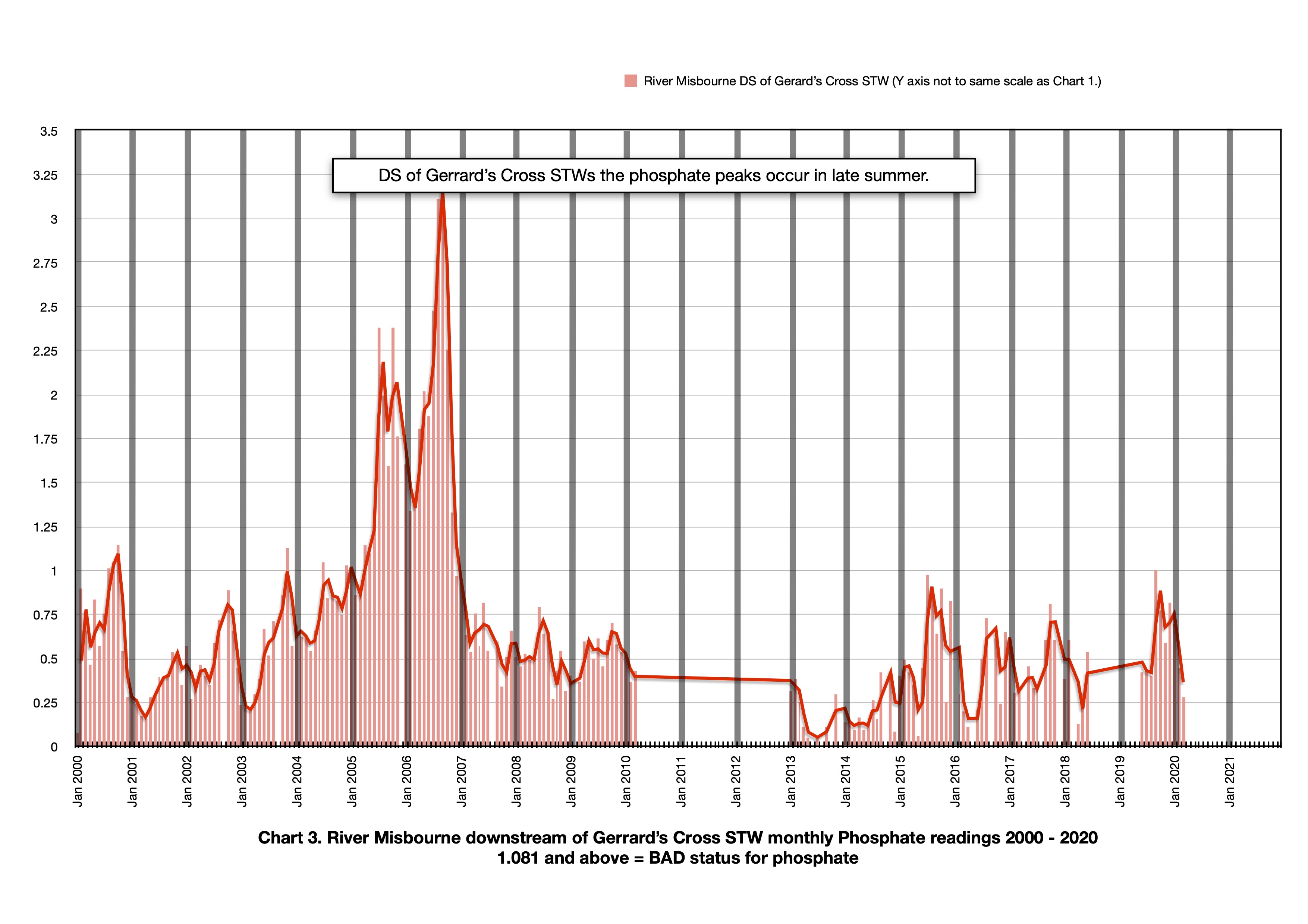
I’ve been making charts of phosphate readings on chalk streams to try and get some sense of the comparative scale of point-source to diffuse pollution on different chalk streams. The Misbourne tells a clear story of this relative impact in a very populated part of the country. On other rivers, especially the chalk streams protected by designation, the picture is more nuanced. But the charts below speak for themselves: the sewage treatment works at Gerrard’s Cross on the River Misbourne (a chalk stream which also suffers from low flows) does not (to my knowledge) feature a phosphate stripper.
Not far upstream of the sewage works the EA Assessment point data shows consistently low phosphate readings, while downstream of the STW the readings are very high.
There are also some clear, and revealing patterns. Upstream the peaks, such as they are, clearly coincide with high flows in the mid-winter, whereas downstream the peaks coincide with low flows in late summer, indicating that the primary source of phosphate upstream is from diffuse, landscape sources while downstream the primary source is quite obviously the sewage treatment works.
The phosphate concentrations go up and down in inverse relationship to each other. At the upstream assessment point increasing flow leads to increasing amounts and concentration of phosphate, whereas downstream increasing flow decreases phosphate concentrations through the effect of dilution.
Phosphate: to those like me who answered their Chemistry O level multiple choice by rolling a pencil down the desk because that way they tended to get higher marks, phosphate is just another chemical. But in terms of river ecology in general and chalk stream ecology in particular, phosphate is very, very important.
That’s why I’ve spent the past few weeks adding info to the Abstraction Sensitivity Band table I published in the previous post in December. The Chalk Stream Table now includes the Water Framework Directive (WFD) status for Flow and Phosphate.
Flow is a “supporting element” and so it is adjudged either to support or not to support Good Ecological Status. In WFD lingo these are the acronyms SG or DNSG. The column for the WFD ‘element’ Phosphate (P), is classified as either High (which means High status and therefore low phosphate concentrations), Good, Moderate, Poor or Bad (Bad means a high phosphate concentration). Phosphate is a pass or fail element: if P readings are Moderate, Poor or Bad the waterbody can’t be deemed to meet Good Ecological Status. There are no absolute readings used to assess status: it is somewhat tailored to each stream. Generally however, P needs to be lower than 0.036 mg/l for the chalk stream to achieve High status.
(Note: I have indicated which Sewage works remove Phosphate as best I can with the information available. The table may include some errors in that regard. Also I have included the actual P readings from the Dorset streams but not the rest (not enough time in the day), but I will in due course. There is no one source of information on this important issue of Phosphate and sewage treatment standards, which is something I hope the new chalk stream hub we are developing will resolve.)
I’ve taken P here as something of a totem for water quality in general, although that is a massive oversimplification. Nevertheless P has a huge impact on the ecology of our chalk streams. If you want to read an authoritative explanation from the expert on this subject I refer you to Phosphorous and River Ecology by Chris Mainstone. This is my Ladybird Book simple version:
Phosphorous is the key chemical that drives nutrient enrichment of chalk streams. That enrichment has a number of deleterious effects on a river’s ecology which increase in line with increasing P enrichment. All plants need P to grow, but different plants and plants communities either thrive or conversely suffer and are out-competed at differing levels of P concentration.
Higher order and important chalk stream plants like Ranunculus thrive at very low, background natural P concentrations. The first effect of P enrichment is actually an increase in the growth-rate of the higher order plants, but with commensurate weakening in root growth – making the plants vulnerable in high flows. As P levels increase further the river’s ecology shifts towards a dominance of the higher order plants that are most tolerant of nutrient enrichment, and that leads to a reduction in the overall bio-diversity of the plant community.
Finally, if P concentrations keep on rising, the river’s ecology will switch over to an algal-dominated plant community. Benthic algae smothers the river bed and the interstices in the gravel in which many insect species live and epiphytic algae cloaks the leaves and stems of the higher order plants, reducing their ability to photosynthesise. The prevalence of algae will also cause extreme diurnal variations in dissolved oxygen levels, with really low oxygen levels at night and in the early morning, which stresses fish and insects alike. There comes a point where, if the P is very concentrated, the river turns into an anoxic soup and nothing much survives.
P is very limited in a natural chalk stream system. But P is contained in human sewage (treated and raw) and animal slurry, as well as in agricultural fertilisers. P is used in cress farms and there is P in the food used in fish farms and in the poo from those fish. There are other diverse sources of P: our drinking water is dosed with P, for example. Consequently there is much more P in our anthropogenically impacted river systems than might be considered natural. Relatively modest increases in P can cause the ecological changes outlined above. Any reduction in P will benefit the ecology of a chalk stream, but if P levels are high, or there’s loads of it still washing around the system, you might have to reduce P by an awful lot before you start noticing the difference.
There are also complex relationships between different states of P, which might be dissolved within the water column (Soluble Reactive P) or bound to organic and inorganic particles which accrete on the river bed: P can move between these two during its journey through a river system, meaning that P locked away within the sediments on the river bed can be reanimated in high flows when the river bed is disturbed.
P gets into a chalk stream through “Point Source” and “Diffuse” pathways.
The main Point Source supply of P is through the human sewage system, but fish farms and cress farms are also Point Source suppliers: a large fish farm (40 tonnes annual production), for example, can generate as much P as a secondary Sewage Treatment Works (STW) serving 1000 people.
Diffuse Source P, on the other hand, flows in multiple pathways from the wider landscape, and particularly from farmland. The majority of Diffuse P gets to the river by surface or shallow sub-surface flow during the wet winter months, when soil is saturated.
A clear pattern you will see in this table is the correlation between chalk streams where there are no sewage treatment works (STWs) or chalk streams where the STWs includes a tertiary P stripping phase which tend to be of Good or even High status for P.
And conversely between chalk streams which have one or several STWs which do not remove P and which tend to be of Poor, Moderate or Bad status for P.
On some rivers I have noted in the r/h column where the P readings were markedly different upstream and downstream of a STW. One stark example is the Misbourne and I will publish a revealing chart of that in the next post.
There are other clear patterns: the relatively higher status for P on the larger systems as you move in a downstream direction. This is because the Urban Waste Water Treatment Directive which has driven investment in P removal over the last two decades applies to larger sewage catchments of 10,000 people or more. Many to most chalk streams do not have towns of that size on them, or if they do it will be in the middle to lower reaches of the larger river systems. Although its a good news story for P removal, it has tended to benefit the lower reaches of larger systems leaving the headwaters and smaller rivers behind.
Another clear pattern is the difference in % of STWs on a given river or in a given catchment that feature P removal and the designated status of the river. All chalk streams are a Priority Habitat, but some are also SSSIs (Sites of Special Scientific Interest) – the Frome, Test, Kennet, Nar and Driffield Beck and some are SACs (Special Areas of Conservation) – the Itchen, Avon, Lambourne and Wensum. These two designations are much more powerful. SSSI and even more so SAC protected status has driven an investment in P removal in smaller-scale sewage treatment works which is clearly reflected in the WFD assessments.
That is not to say that our SSSIs and SACs are perfect. They clearly still suffer phosphate issues as some charts I will publish in due course show. But it does make the point very clearly that if we want to effect real change for all our chalk streams, right across the map from Dorset to Yorkshire, we need to look at the protected status of all chalk streams, not just the shining examples. Much of the anger and frustration felt by people who care about chalk streams is driven by the condition of the Cinderella streams that are still bedecked with sewage works (there are 175) which do not remove Phosphate. Priority Habitat as it stands is clearly not a sufficient imperative to action. Protected status is symbolically important, but more than that it drives investment. And investment is what these rivers so desperately need.