The slow death of a chalk stream

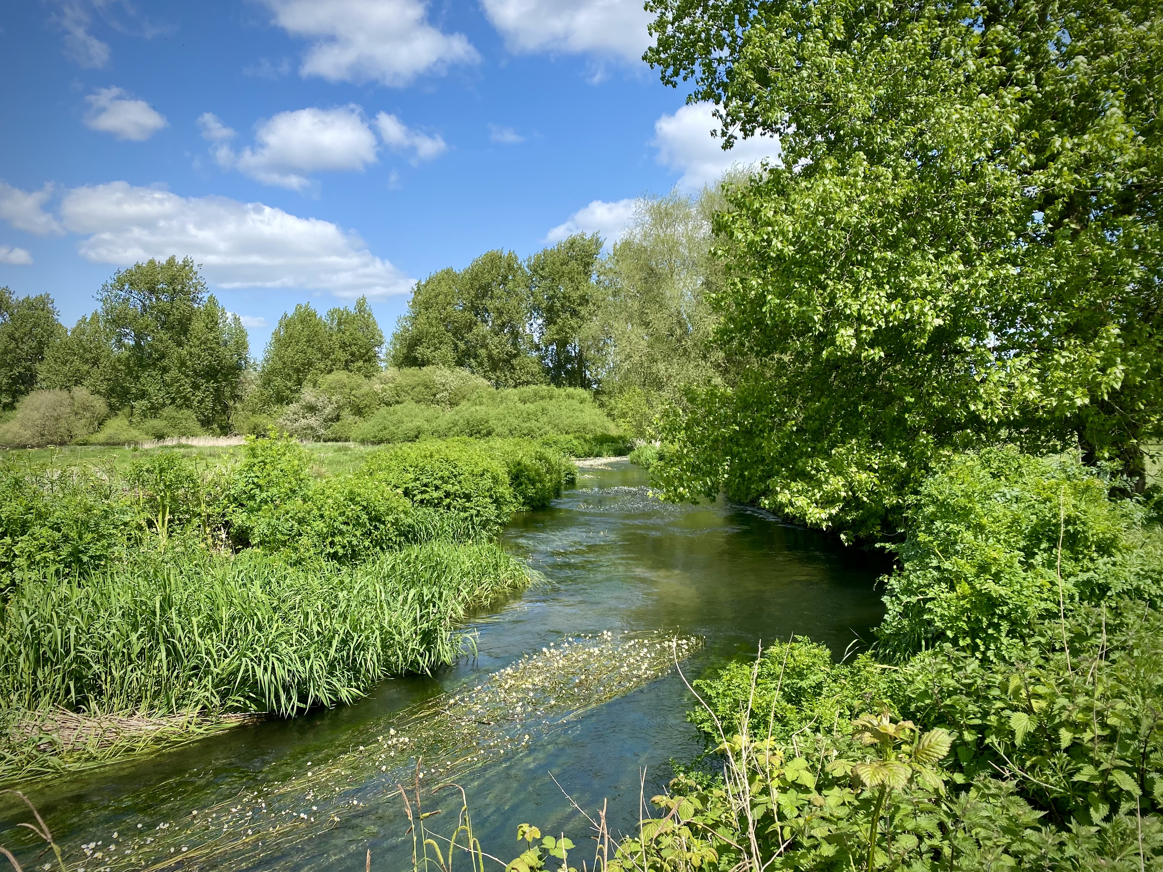
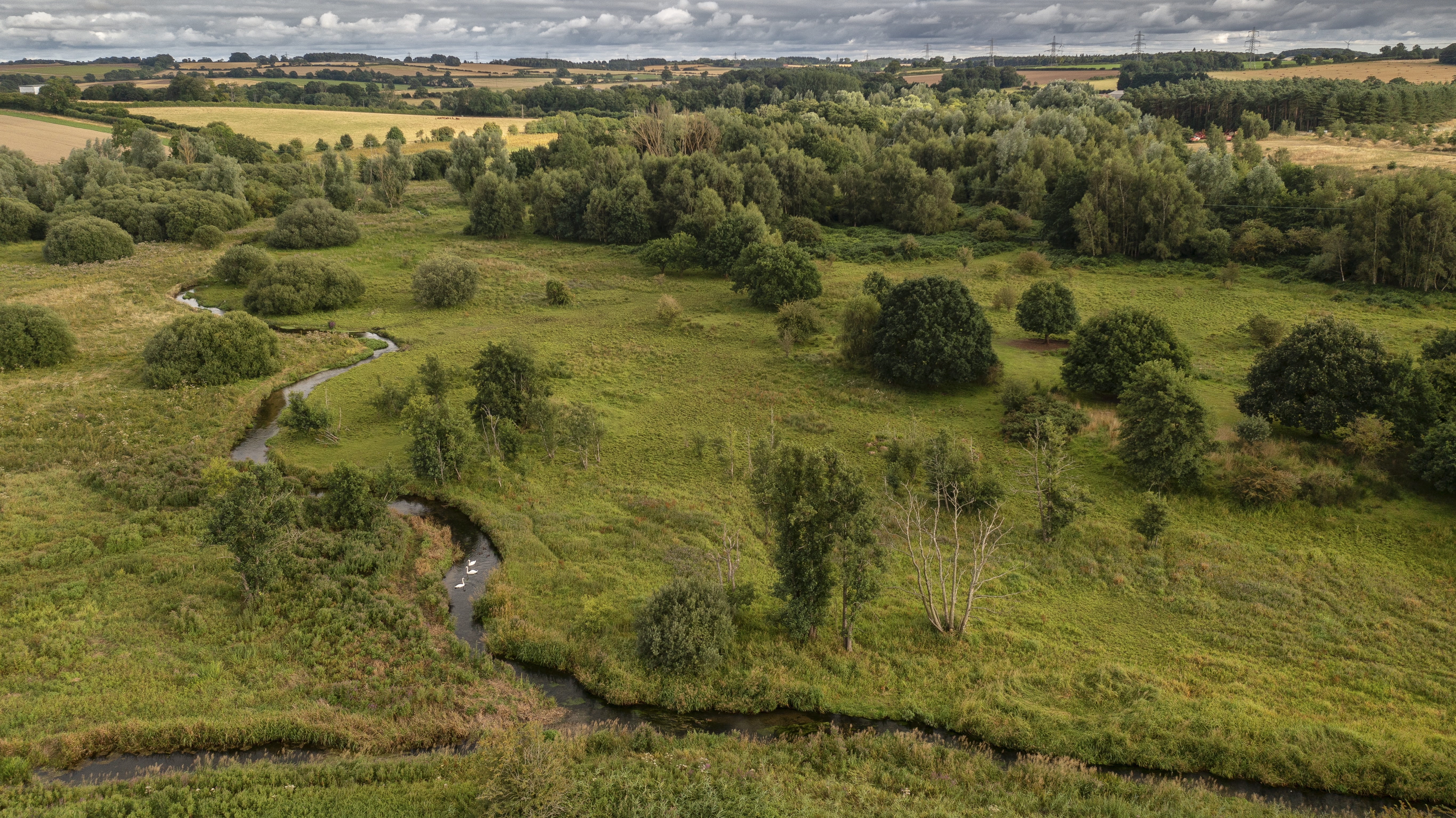
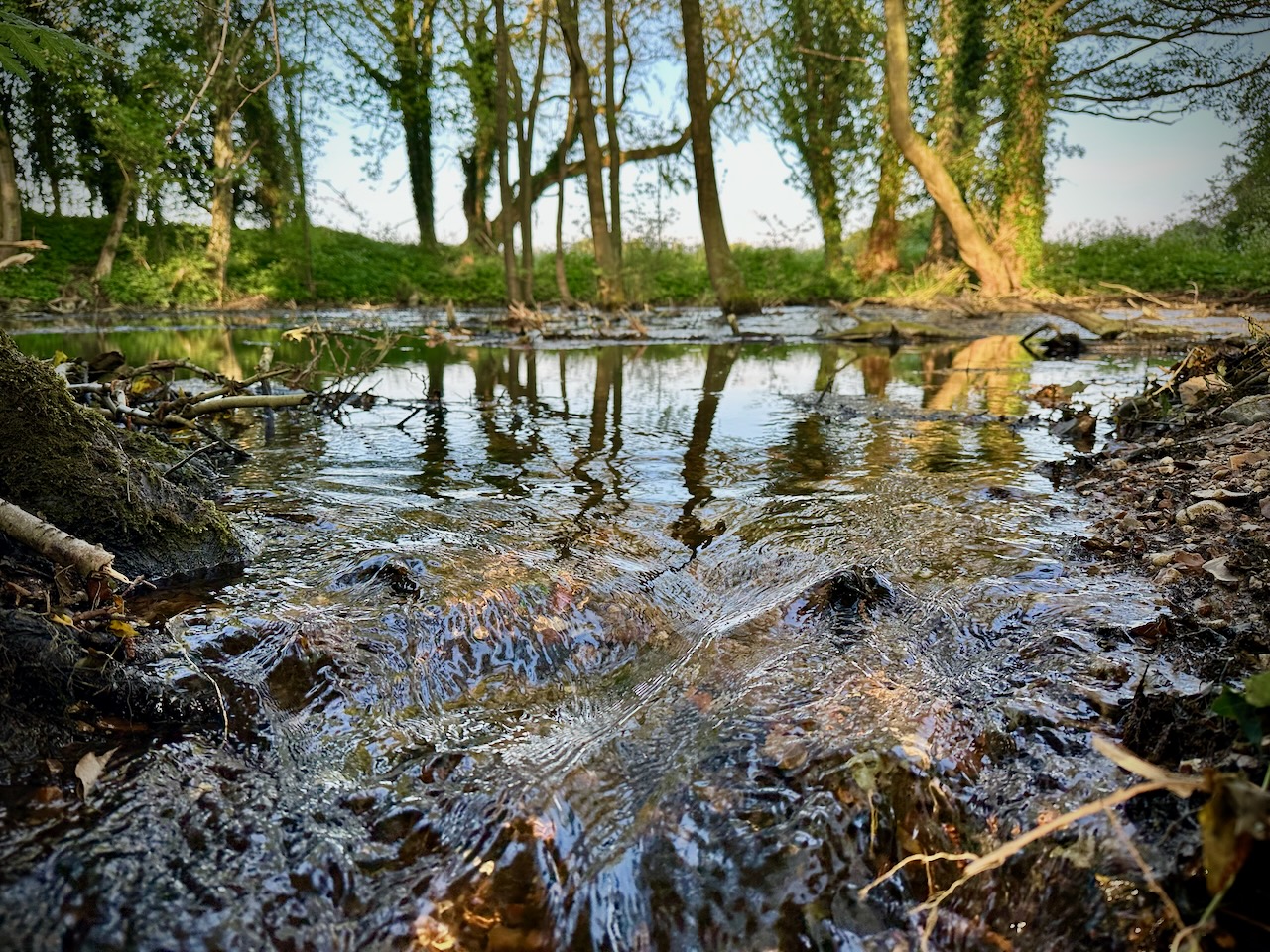
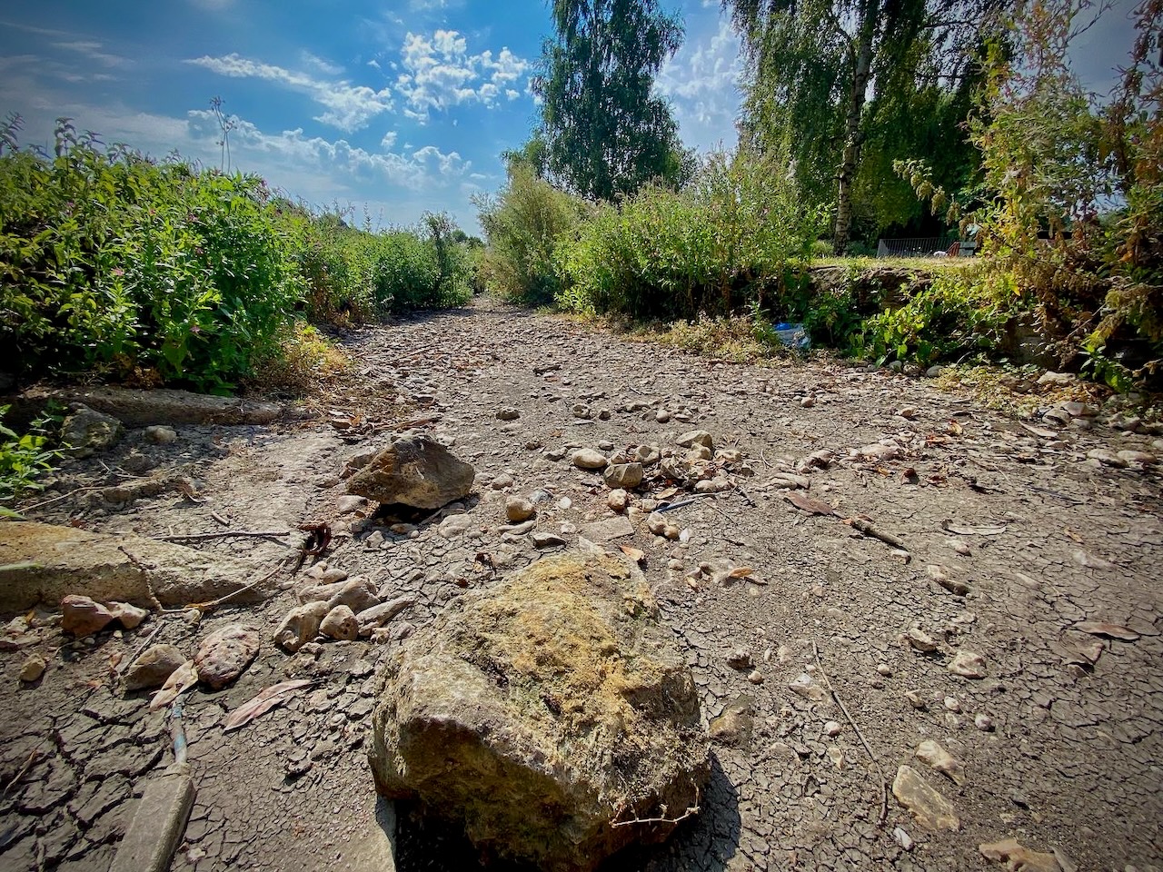
The little River Tarrant is a beautiful chalk stream in Dorset, the site of five Domesday watermills and the home of spawning Atlantic salmon. The lower river has dried occasionally in the past but never before the era of groundwater abstraction. Now it dries every summer. Locals say this is down to increasing abstraction. Wessex Water says otherwise. 

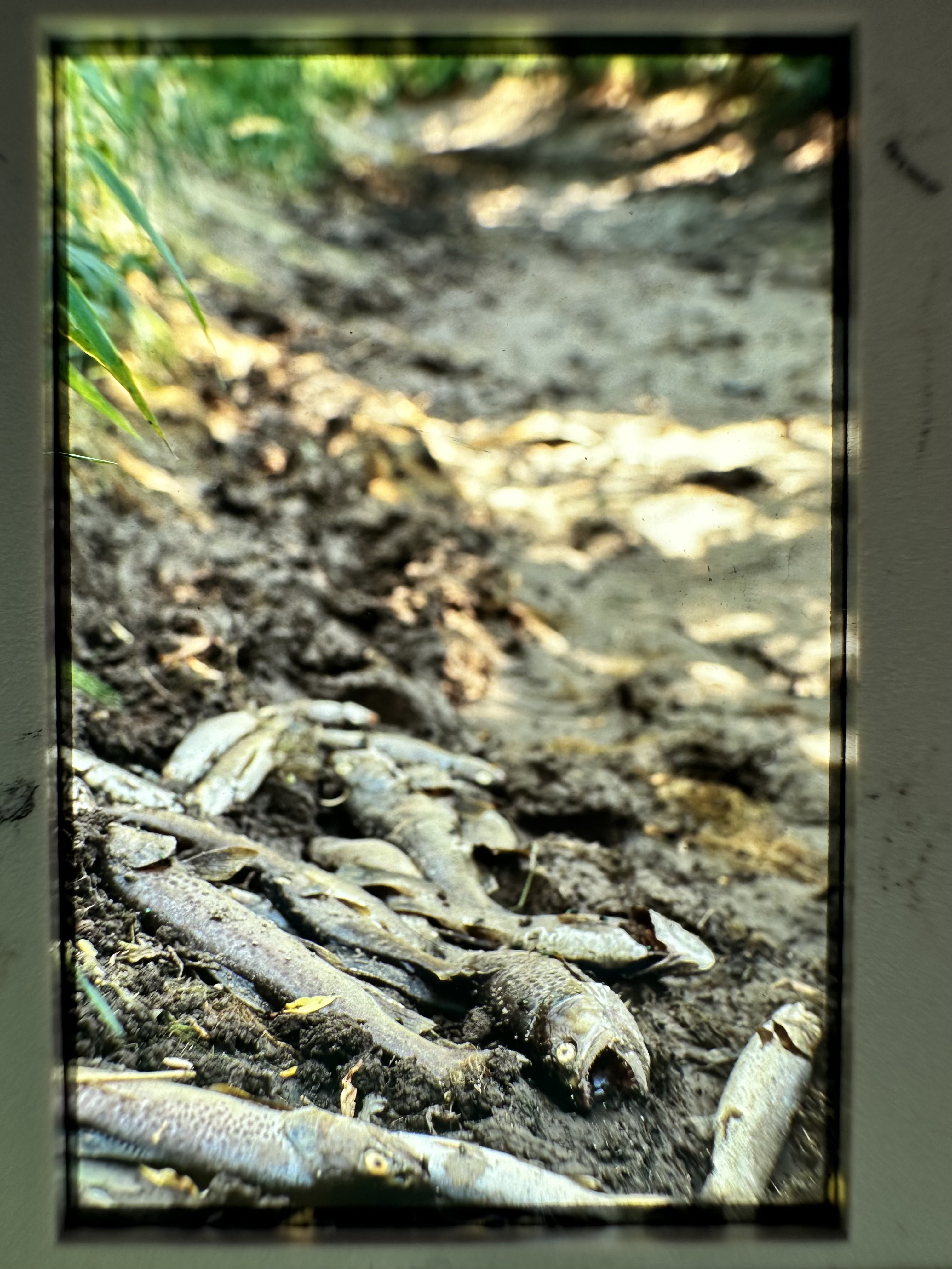
The March issue of The Field includes a feature by me on the poor little River Tarrant in Dorset. I first wrote about the unnatural drying of this stream 30 years ago after it vanished through its riverbed in August 1995, leaving 100s of trout dead in the caked mud.

The slide I took in 1995, the morning I went back to the Tarrant and found the river had vanished overnight

Back then, although abstraction had started to increase, the total loss of the lower river was relatively rare. Now, it dries in its lower reaches every single year. That and the fact that, in spite of this annual, unnatural drying, the river is assessed by the Environment Agency as “supports good ecological status” for flow brings into the spotlight the state of play in our work to mitigate and reverse abstraction’s impacts on chalk stream health. 

The River Tarrant is a metaphor for the stasis in the regulatory system. The way this lovely chalk stream has been exploited and ignored over the decades is shameful.

To condense its story before I get into the techie stuff: the River Tarrant is a small chalk stream in Dorset, a tributary of the Stour. It is a slope-face stream, meaning it rises within the outcrop of the chalk downs which run north from Blandford towards Shaftesbury and flows south and east down the strike of the chalk slope. This makes it a classic, natural winterbourne in its upper reaches. The river length rises and falls as the groundwater in the unconfined, outcropping chalk aquifer rises and falls. It can dry, also naturally, in its lower reaches too, where there is a fault line in the chalk running perpendicular to the valley. As groundwater levels fall through the summer and especially in droughts, the lower river loses water to the ground.

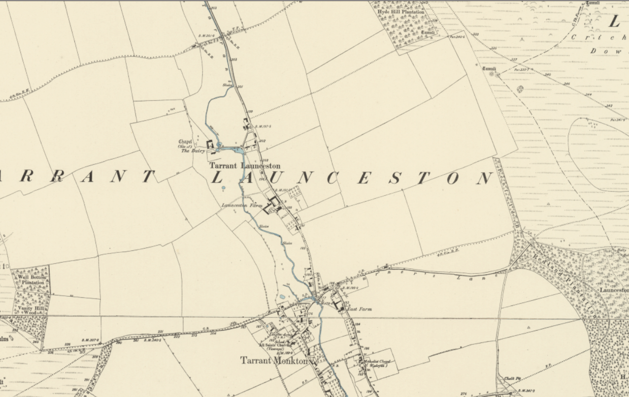
However, the extent – by that I mean the physical and temporal extent – to which the Tarrant is a natural winterbourne is the subject of some debate. Historical evidence strongly suggests that the Tarrant is only a natural winterbourne in its upper reaches downslope as far as Tarrant Launceston, where old maps and LiDAR indicate that a meandering channel, suggestive of perennial flow conditions, begins.

Tarrant Launceston, where the valley opens out and there is evidence in the planform and floodplain of a perennial channel

Research by Dr David Solomon for a report recently commissioned by the River Tarrant Protection Society (more on that very comprehensive report, primarily authored by John Lawson, later in this post and a link at the end) has shown that the River Tarrant did occasionally dry further down the valley in the past, before groundwater abstraction was much developed, but so rarely as to make the local press when it did so. 

It dried in Tarrant Monkton – a little further downstream than Launceston – in 1929 and 1933, both years of severe drought. There is no historical evidence of it regularly drying up in the lower reaches, however, albeit in 1970 Dr Stanton, a hydrologist, wrote: “In exceptionally dry years the river is dry just above the confluence with the Stour”. We know it dried in 1976 and it clearly shrank away to almost nothing in 1989 as noted by the National Rivers Authority, by which time the river was being more heavily abstracted.

The River Tarrant once supported several water-mills, at least five of which were Domesday mills. While the Domesday book did record “winter mills” molinum hiemale, none on the Tarrant are so described. All of the Tarrant mill sites are downstream of Tarrant Monkton, lending more weight to the idea that our ancestors preferred to construct mills where flows were reliable. 

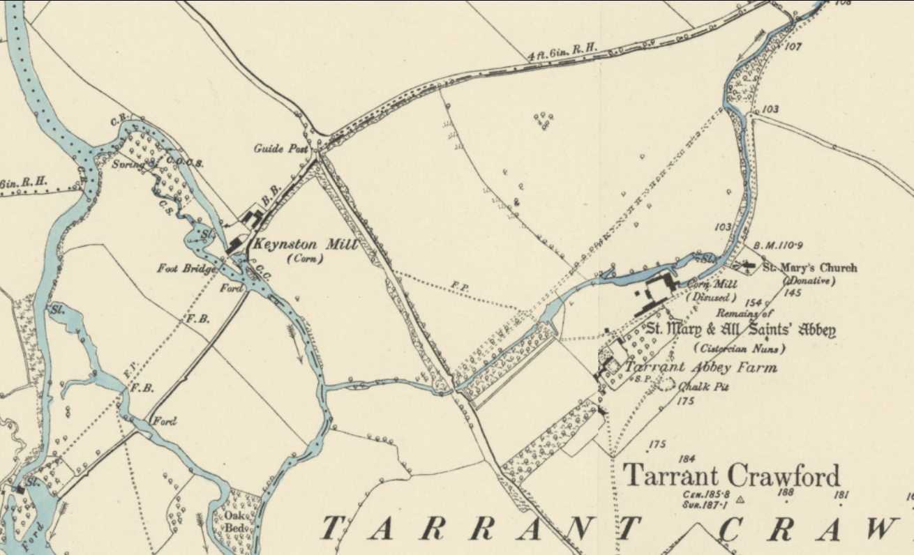
The mill site at Tarrant Crawford Abbey seems particularly anomalous to the modern-day ephemeral flow regime of the lower river. This was a substantial mill with a dedicated water-retaining structure and leat, sited very close to the confluence of the main Stour and another watermill – Keystone Mill – that would have been a better option and wholly reliable if the Tarrant had tended to dry.

Why build a pre-Domesday mill at St Mary and All Saints Abbey on the Tarrant if the flows there were ephemeral and a perennial mill existed only a few hundred yards away at Keyntson Mill on the main River Stour?

Meanwhile, Atlantic salmon persist in behaving as if the Tarrant is not a natural winterbourne. They are mentioned in 19th-century issues of The Field as regularly coming up the river to spawn, and there are numerous records of salmon in the river in recent years, including of salmon parr in the now all-too-frequent and necessary fish rescues. As is well known, salmon tend to spawn where they were themselves spawned: they imprint on the chemical signature of the water and stones in which they hatch. That genetic memory and behavioural fidelity – which goes back tens of thousands of years – ought to tell us something: salmon don’t spawn in natural winterbournes. Any salmon that chose natural winterbournes in the past will not long have succeeded in passing genes and progeny to the next generation.

A salmon parr from the Stour close to the Tarrant tributary

All of this and more – for example, the memory of ancient locals interviewed by my wife Vicky in 1995 – strongly suggest that the Tarrant is naturally a perennial chalk stream downstream of Tarrant Monkton, and that while it might naturally have diminished in its lower reaches in drought years, it didn’t tend to dry up. There is no documented record of the lower river drying before groundwater abstraction began.

So, how come it now dries in the lower reaches almost every year? 

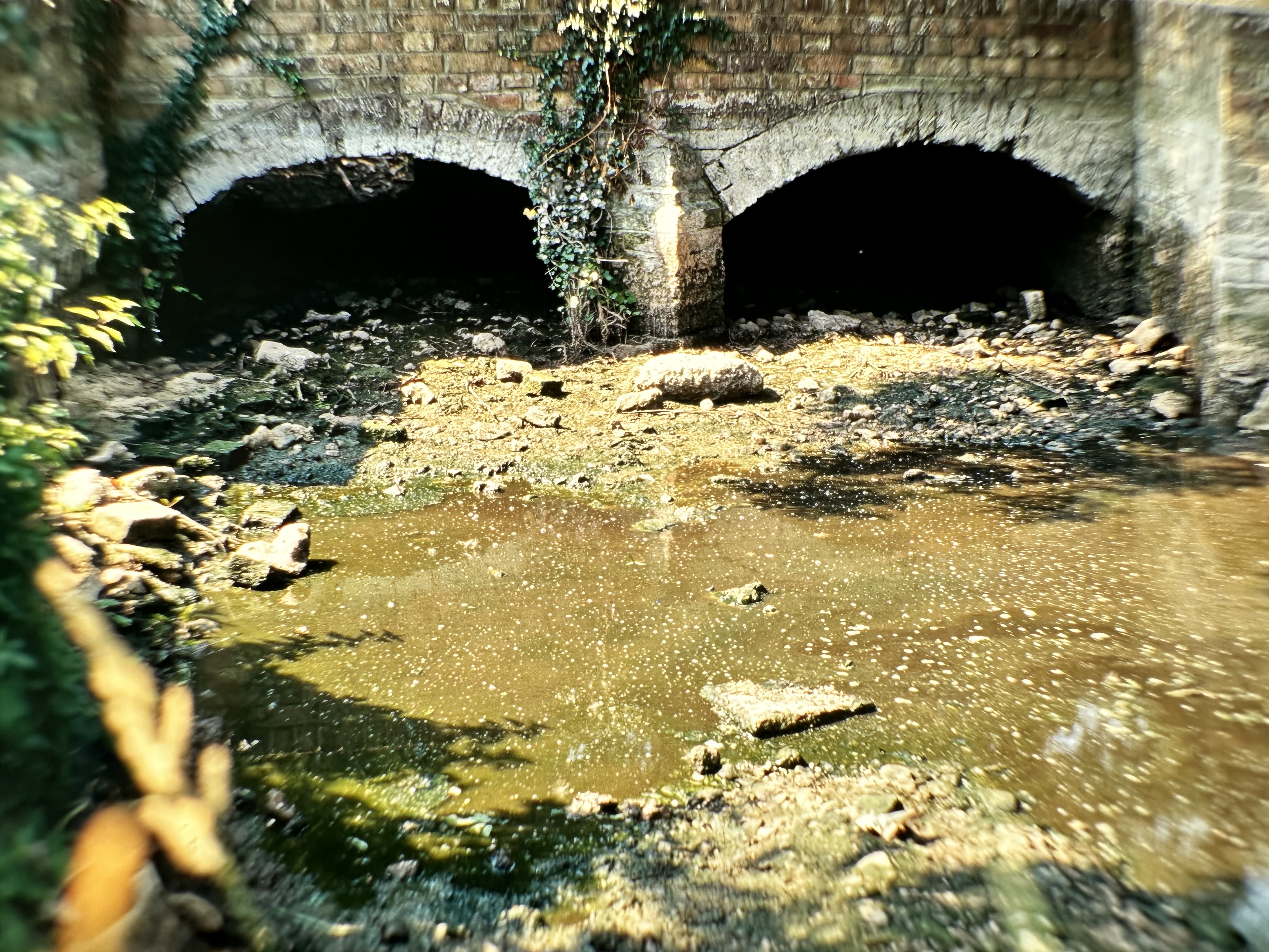
In 1995, when we rescued all those fish and failed to rescue so many more, the drying came as a shock: I had known the stream since 1987. It had dried in 1976— a drought comparable to 1929— but kept flowing for 99.9% of the next 19 years, with only the lowermost kilometre briefly drying in 1989. I fished it often in the early 1990s when two- to three-pound trout were not unusual. It was my best-kept secret. And yet, in eight of the past nine years, the lower river has been dry for between 46 and 120 days in the year. 

The Tarrant, especially the lower Tarrant, has changed. Why?

The dried out lower Tarrant in 1995. It had dried before, in 1976, and 1989, all years of severe drought under an already heavy abstraction regime. Since 2017, it has dried every single summer.

“Just one more thing …”

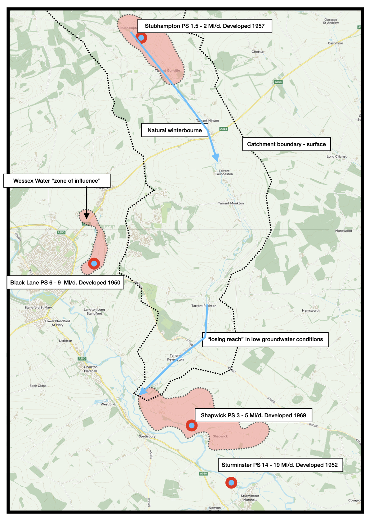
The answer, I believe, lies in the telling fact that the one year— 2017— in the past decade when it didn’t dry in the lower reaches was the one year when Wessex Water shut down its Black Lane pumping station, which lies in the next valley over by the Pimperne Brook.

If Columbo were a natural history detective, he would at this point stop and say, “Just one more thing …” then ask how much it had rained in the preceding winter. Not much, is the answer. The spring of 2017 was a disaster for chalk streams: I was commissioned that year to take photos for WWF of all the chalk streams near London that were bone dry, also largely because of over-abstraction. 

And yet, this one year of all years, the lower Tarrant kept flowing?

Wessex Water claims that the Black Lane pumping station cannot impact flows in the Tarrant, not least because there is a hill in the way. 

And yet, water companies are often the first to point out that subterranean catchment boundaries are not the same as surface watershed boundaries and are dynamic too, capable of naturally migrating as groundwater levels rise and fall. For example, the aquifer under the true Winterbourne in that area, the ephemeral stream that confluences with the Stour on the opposite side of the valley from the Tarrant, and tellingly called “Winterbourne,” is also connected to the Bere Stream in the neighbouring Piddle catchment. In numerous meetings, this natural phenomenon of dynamic groundwater boundaries has been spelled out to me, as water company hydrogeologists caution against the simplistic notion that reducing abstraction in a given valley will lead to restored flows in that valley. 

As this image from the University of Wisconsin neatly shows, groundwater divides can very much be shifted by abstraction pressure

And yet, conversely, the same water companies have also argued for the existence of glass walls between one chalk valley and the next. The Lea, for example, is very heavily abstracted, but apparently, that impact simply can’t translate across to the neighbouring Ver or Mimram. The abstraction in the Beane simply can’t affect the Ivel, or vice versa, etc. Like those watershed boundaries, the argument is dynamic and tends to suit the point being made.

As John Lawson’s report shows, there are several abstraction pumps in and around the Tarrant, and groundwater abstraction has crept up slowly over the years. The one source within the physical, surface catchment – Stubhamptom – is relatively small and has been running since the late 1950s. But there are much bigger pumps at the aforementioned Black Lane (just over the catchment boundary), and Shapwick (close to the confluence with the Stour), and Sturminster Marshall (a little further down the Stour valley), as well as Corfe Mullen, which is slightly further afield.

The aggregated impact of just the former three climbed from about 5 ml/d in the early 1970s (by when Stanton observed that the lower river dried in exceptional droughts) to about 10 Ml/d in the early 1980s, and peaked at about 15 Ml/d in the 1990s, when I was forced to rescue those trout in the 1995 drought. 

By the early 2000s, the aggregated abstraction of these three pumps had fallen back to between 5 and 10 Ml/d. Then in 2016 and 2017, abstraction was reduced to about 6 Ml/d and in 2017 for a short period, to almost zero. By the end of 2017, it had ramped back up steeply to about 15 Ml/d, as the Wessex Water grid came online and “underutilised” sources in the Stour valley were used to aid reductions in the more protected Avon catchment.

Since then, the Tarrant has dried every year.

Wessex Water maintains that their sophisticated tests and modelling show that the Black Lane and Shapwick pumps don’t affect flows in the Tarrant. 

Their case rests on the analysis of what are called switch-off tests, when they shut down pumps and look for the rebounding impact on groundwater levels in the surrounding area. This helps to define the ‘zone of influence’ (a misnomer – see my argument below) or more accurately the ‘cone of depression’, a funnel-shaped depression in the water table: a bit like the vortex that descends to a plug hole. 

The cones of depression of either Shapwick or Black Lane do not reach the Tarrant Valley. At least not enough to influence drying, Wessex Water says, adding that an impact is exceptionally unlikely because the chalk between the valleys is less ‘transmissive’ (i.e. the movement of water through the chalk is more restricted) than within the valleys. 

Their findings have been accepted by the Environment Agency.

A map of the River Tarrant showing where the river is a natural winterbourne, where it loses water in the lower reaches, the location of pumping stations, and their so-called “zones of influence”

Bringing sticks to a gunfight.

As a community of campaigners, we have struggled to fight the over-abstraction of our chalk streams in no small part because we don’t easily understand the way groundwater drives river flows or the ways groundwater abstraction impacts river flows. As a perfect example, the idea of lessening abstraction in summer – which more or less every lay person still thinks is the right time to reduce abstraction (or the worst time to increase it) – made it all the way from being a collective NGO recommendation to becoming an Ofwat incentive, when it is generally the least effective time to limit groundwater abstraction, because the impact of the reduction is not generally felt at the time it is made.

We are easily baffled, firstly by the sometimes counter-intuitive ways in which groundwater and flows respond to abstraction and secondly by the sophisticated arguments of the water companies or their consultants. If we were universally better informed, we might do a better job of combating the radar chaff thrown in front of our heat-seeking ire.

I knew nothing about all this groundwater stuff this time in 1995. I just had a strong hunch that abstraction must be to blame because it is logical to conclude that if you take water out of a natural river system, it must impact flows from that system. That logic still holds, by the way. But there are complexities to this mephistophelean science, and it is best we try to understand them.

Ob-fudge-scation

Three decades ago, water companies, the river authorities, and their consultants generally tried to fudge the impact of abstraction on river flows. In systems as complex as spring-fed rivers, it was easy and too tempting to dissemble and deflect.

As just one example, in the 1990s, Atkins wrote a report on abstraction impacts in the River Kennet. They stated:

  • “There is no clear evidence that groundwater levels over the catchment have been affected by groundwater abstraction.”
  • “There is no strong evidence for any change in the distribution of minimum groundwater levels over the catchment…”
  • “Ongoing abstraction does not have a cumulative effect… Both groundwater levels and surface flows stabilise at a lower level…”

That last statement is particularly disingenuous, deliberately designed to confuse the lay reader. It allows for the stabilisation of groundwater at a lower level, having previously stated that there was no evidence this was occurring and then conflates the idea of ecological damage only with cumulative groundwater mining. 

Notice the phrasing, the refrain of “no strong evidence” as a caveat? We could characterise this as systemic minimisation and an insistence on evidential uncertainty. It is designed to disable the protest. People had noticed the drying up of chalk streams, but countering this kind of specious guff was very challenging unless you had a PhD in hydrogeology and didn’t work for a water company, the agencies or one of their consultants. Which is no one with a PhD in hydrogeology.

In fact, the NGO movement has been turning up at gunfights armed with sticks for several decades. Only John Lawson – who started out battling that exact same Atkins report and the unsustainable abstraction of the River Kennet where he lives – has made a really effective stand here on behalf of the NGOs. He deserves a sainthood, let alone a knighthood. One of the cleverest people I know and a very good, highly qualified engineer, he and his work are routinely dismissed and patronised by the hydrogeological cabal. 

Computer says “we don’t know”

While the socio-economic benefits are still just as real today as in the 1990s, water companies no longer fudge the theoretical case quite so brazenly. In practice, however, and on a case-by-case basis, they argue the toss every single time. They have very strong economic motivations to do so. And they manage quite successfully too, because as our knowledge of these systems has become more sophisticated, the ability to hide action behind uncertainty has increased.

Our understanding of the chalk aquifer has developed over recent decades, so that what was once seen as three basic strata is now understood as many different strata comprising different chalks of varying age, hardness and structure, intersected by layers of less transmissive horizons, riven through with karstic flow-ways. About this infinitely complex underworld, the more we know, the less we know for sure.

Groundwater modelling has also become much more high-tech over recent years. We now have conceptualised, computerised aquifers, with gazillions of cells imitating the aquifer properties, which can run numerous scenarios and impacts. And yet – so it seems – we can never know enough to state anything for certain. Thus we have replaced the fudging with an insistence on preceding any action with full knowledge, attained only via immensely sophisticated modelling that is privy to water companies and the Environment Agency, the two players who are motivated to maintain the status quo. 

There’s too much money at stake for water companies. Too much work at stake for consultants. The socio-economic value of groundwater renders the precautionary principle a pipe dream. eNGOs and protesters are still impotent and hobbled by their relative lack of expertise and resources.

And thus every chalk stream in which the abstraction pumps run is a new arena for endless investigation.

So, it is with the Tarrant. The complexity allows the can to be kicked. Again and again and again.

Newsflash!

The River Tarrant Protection Society commissioned John Lawson to write his report well over a year ago. It contains a very cogent case for casting doubt on the joint Wessex Water and Environment Agency conclusion that the river Tarrant is unaffected by local groundwater abstraction. It includes a pragmatic proposal for how to relieve pressure on the River Tarrant and asks, at the very least, for the Tarrant to be properly included in the next round of AMP investigations.

There is a great deal of historical and anecdotal evidence in the report, but the bulk of the report covers John’s analysis of the formal modelling and his own, simpler, but empirically accurate modelling methodology (which hydrogeologists tend to dismiss). This shows that the recent actual flows only fit the modelled outputs when the pressure on the regional groundwater table, including that exerted by the pumps at Shapwick and Black Lane, is taken into account. 

John’s conceptual model – I will try to unpack it below – underpinning his numerical model is based on the idea of the aquifer as a regional entity, that allows for the inclusion of neighbouring catchments. In theory, this inclusion could radiate as far as the boundaries of the aquifer. In practice, John does limit it to keep the data input manageable. John’s conceptual aquifer is – I will argue – theoretically accurate, but hotly denied by any water company that encounters John’s work.

John shared his report with Wessex Water and with the Environment Agency last September. Christopher Greenwell, the EA’s water resources strategic lead, replied a few weeks later, promising a detailed review of the report and a meeting to discuss, with an update by the 12th December 2025. 

The update never came and had to be chased. The EA replied in mid-January to say that the groundwater team was reviewing the report. In March this year, Christopher Greenwell replied, saying that his groundwater colleagues would commission a review (so had they been reviewing the reports in January or not?) and a comparison of John’s groundwater approach, as well as the methodology used in the Wessex Water / EA chalk basin model, “to be carried out by an external party to avoid bias and give greater confidence to all parties”. Asked for a bit of clarification, Christopher confirmed that the review would not concern itself with anything in the report other than a comparison of the conceptual models.

So, John’s David to the Wessex Water / Environment Agency Goliath then? With the review conducted by a third party who is fully objective? We shall see.

In the meantime, back to the complexity … and those conceptual models.

Groundwater for Dummies

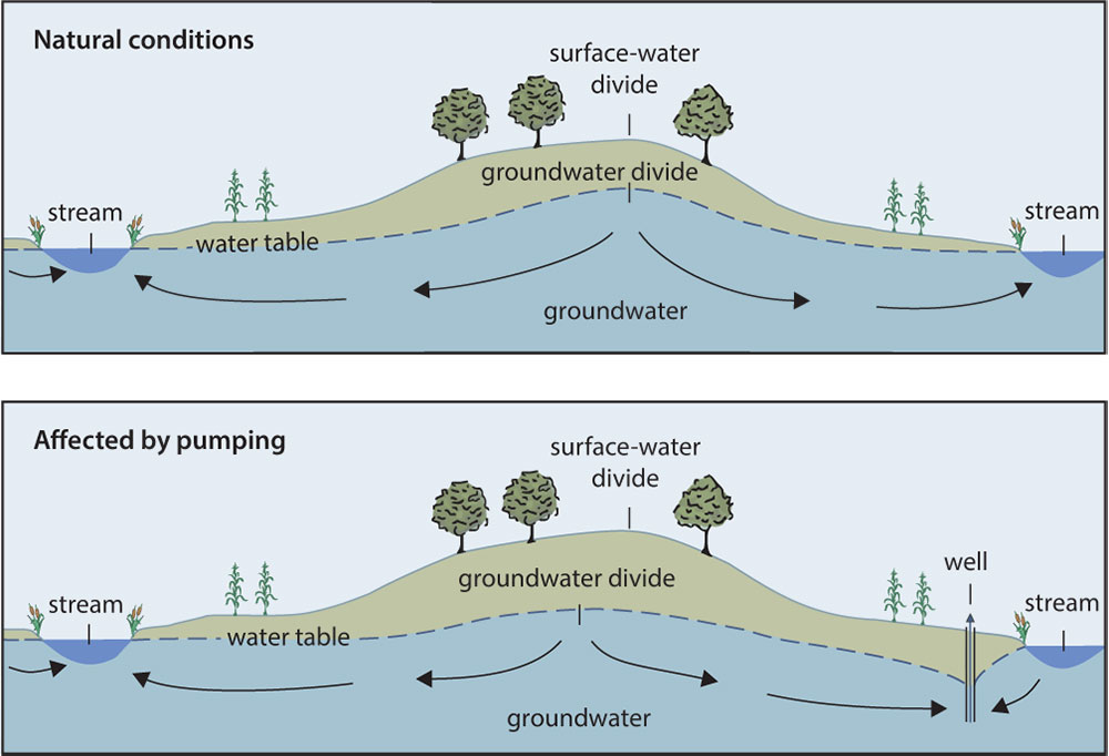
It really isn’t that complex. Or rather, any complexity that exists overlies a basic, unarguable simplicity. Groundwater abstraction from a spring-fed system will lower stream flows from that system. There’s no real, honest debate over whether it does, or even by how much it does (over time, by the same amount as the abstraction). The debate, such as it exists, is over where the impact is felt and more challengingly, when it is felt. 

This provides all the wriggle room needed, however.

Time

The role of time can be difficult to get your head around, but – at first – let’s imagine the underground aquifer as a large surface lake, with many streams and rills running into it from the surrounding hills, but only one river draining it. Loch Tay, for example. If we eliminate evaporation, and any loss of water through the lake bed, the amount of water flowing out of the lake must equal the amount coming in.

But the correlation between inflow and outflow is not continuously simultaneous. When it rains it will take time for the water in the lake to rise and force more flow to leave the lake. And when it stops raining and the lake level is high, it will take time for the lake level to fall and the outflow to diminish, until it once again balances the inflow.

The system is in a state of dynamic stability and equilibrium. Inflows, lake level and outflows all vary all the time, as rain comes and goes, but ultimately inflows equal outflows over time.

Once that is grasped, it only takes a bit of imagination to increase the size of this mind’s-eye lake and appreciate that time will lag to a greater and greater degree between the impact of inflow on lake level and outflow as the lake gets bigger. A headwater stream in flood rushing into Lake Windermere (6 square miles) will force up the level of the lake and the outflow more quickly than it would rushing into Loch Neagh (150 square miles).

If we now add another form of outflow (let’s say we drill a great big pipeline through the hill and divert a large proportion of the lake’s recharge into a neighbouring valley), the former outflow (the river draining the lake) will have to go down. 

However – this is key – it will take time for the new outflow to drain the lake down to the point where it captures that former outflow. 

But capture it, it will.

How long it takes depends on the relative size of the new outflow and the size of the lake. But, no matter the size of the new outflow, there must eventually be an impact on the former natural outflows that exactly equals the new outflows, and the mechanism for that impact is the lowering of the lake level. Even if the abstraction is small, maybe only 5% of the former discharge, and the new outflow is a long way away from the natural outflow, it will be felt, in time, once the lake has lowered by the commensurate amount. 

That surface system is fairly easy to get your head around.

Going underground

The complexity comes when you turn the surface system into a groundwater system. The fundamental concept of the water balance remains exactly the same, however, meaning that you can’t add an extra form of discharge (abstraction) without lowering the former natural discharge.

Historically, water companies have argued that you can and have used obtuse arguments to say as much. Setting the precedent for this, in the mid-19th century, the London Water Company started to abstract water from the River Gade, a chalk stream still bedevilled by abstraction. When the millers on the Gade complained, the London Water Company recruited scientists to argue that their abstraction didn’t and couldn’t lower the river flows. They were taking water, so the Victorian boffins argued, from a limitless well so deep underground that it wasn’t connected to the surface system, something the millers were able to show was nonsense. The courts found in the millers’ favour but kicked any reparation into the long grass of the future, a debate and conclusion which is eerily familiar in the Chilterns to this day. 

Knowing therefore that when the lake becomes an aquifer, the impact of the abstraction remains non-negotiable, the components of when and where do become harder to pin down.

When and where

We have already seen in the lake analogy that the timing of the arrival of impact at the outflow varies according to the size of the lake because the new outflow must reduce the water level in the lake in order to have an impact on the former outflow. 

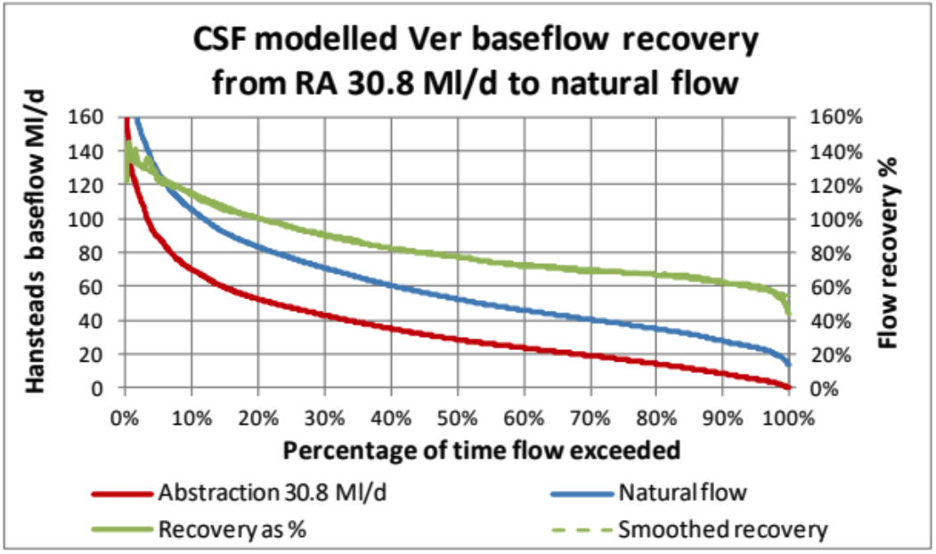
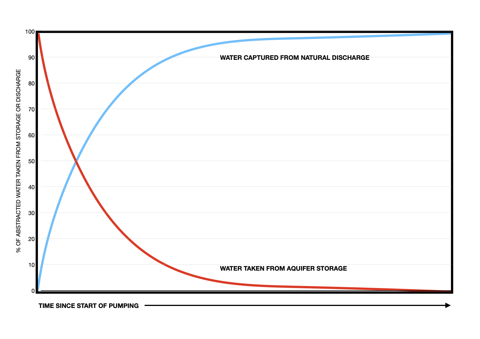
This is the same with an aquifer. A groundwater abstraction must first lower the water level in the aquifer in order to then capture former natural flow from the stream. Thus, in the first instance, an abstraction – depending on where it is sited – may have an almost undetectable influence on former stream flows while it takes water from the volume stored in the aquifer. Eventually, however, the abstraction will reduce the storage and lower the groundwater levels enough to establish a new dynamic balance in the level of the aquifer, after which ALL of the abstraction is captured from the former natural flow. This split over time between water taken from storage and then water taken from flow is illustrated in the diagram below.

The key idea is this:

The means by which groundwater abstraction captures stream flows is by a reduction in the storage of the aquifer and a lowering of groundwater levels to establish a new dynamic balance.

This lowering of the water table changes the hydraulic head across the entire aquifer, which is what lowers the natural flow.

This basic and inalienable truth was defined by Theis in 1940, but is befuddled all the time by water companies as they smudge the issue of whether any particular abstraction is having an impact on any particular stream.

Wessex Water, for example, argues that relatively short-duration switch-off tests (mentioned earlier) define the boundaries of the cones of depression in their analysis of abstraction impacts around the Tarrant and then misleadingly conflate these boundaries (partly by now renaming the ‘cones of depression’ as ‘zones of influence’) with the limit of the influence of the particular, individual abstractions.

They argue this, in spite of the fact that the impact of any given abstraction extends – in theory – infinitely from the location of the abstraction, its only real boundary being time. The cone of depression is simply the measurable drawdown around a pumping well, forming a gradient that drives water to the wellhead. The edge of the cone is not a physical boundary at all, it is a detection threshold where the drawdown is less than any possible measurement error. 

This diagram tries to show that the radiating impact of an abstraction in a uniform, infinite aquifer is – in theory – bounded only by time. The cone of depression is only the limit of the measurable drawdown.

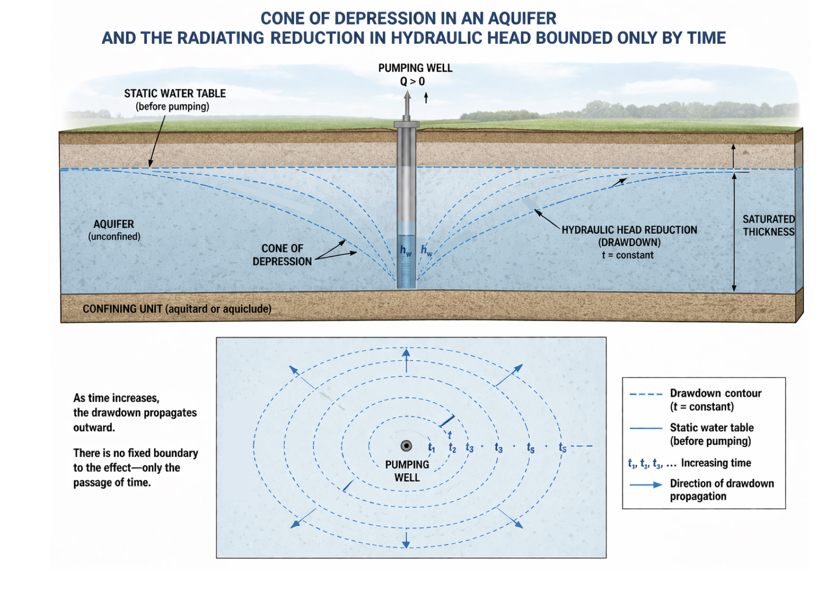
In short, the use of the cone of depression is a water resources construct to help simplify modelling and analysis.  In reality, the system actually responds as a continuous, radiating field of change in hydraulic head.

How groundwater abstraction actually affects natural systems.

The so-called zone of influence is actually only the measurable depression, one that is imposed on a much more widespread reduction in the dynamic level of the water table, that reduction exactly equating, over time, to the reduction in head needed to capture former natural discharge and establish a new dynamic balance. Groundwater abstraction alters the natural distribution of hydraulic head everywhere in the system.

Although the system’s boundaries are – in theory – only limited by time, in practice they may effectively be defined by other factors (and Wessex water contends that these factors are relevant). These could include:

  • impermeable layers – for example thick layers of clays and flints between layers of chalk.
  • aquifer boundaries – the chalk aquifer obviously ends where the chalk ends. Although it may well connect with other aquifers, the boundary of the chalk may mark an effective boundary for the purpose of analysis.
  • recharge boundaries – large rivers or lakes / wetlands can supply the water being demanded by the abstraction and therefore limit the effective growth of the water-table reduction. It’s possible the River Stour floodplain is a recharge boundary in the case of the Tarrant.
  • changes in transmissivity – this is what Wessex Water rests much of its case on, especially the transmissivity under the catchment boundary.

Those effective, possible limits notwithstanding, groundwater abstraction is actually a time-dependent redistribution. As I have shown, it can take a long time for abstraction to capture former natural flows.

Stage 1. Duration – days, weeks or months.

The water demanded by the pump comes almost entirely from storage. The impacts are localised and at this point they are indeed mostly felt within the cone of depression.

Stage 2. Duration – months to years.

The abstraction begins to impact nearby streams and wetlands. This is when the abstraction starts to impact hydraulic gradients in an ever-widening orbit, taking less and less water from storage and increasingly more from changes in the boundary flows.

Stage 3. Duration – long-term new equilibrium, years to decades.

This is the stage beyond which the groundwater abstraction must, according to immutable laws of physics, take its water from the capture of former natural discharge. Most of this will be a reduction in the former groundwater discharge to the chalk streams. Some will also come from “induced recharge”, driving leakage from the stream bed (this is absolutely what is happening in the lower Tarrant), and from lowered evapotranspiration (because the water table is lowered). 

Over time, the depletion from former natural discharge approaches the pumping rate, until almost all is taken from the stream system.

Just as it can take a long time for abstraction to lower groundwater levels and capture former natural outflows, it must therefore take a long time for a reduction in abstraction to lead to fully recovered groundwater levels and a full restoration of former natural flows.

Switch-off tests lasting only a few days, weeks, or even months will do nothing more than allow the cone of depression to refill and so help define its boundary. This is not the same thing as the limit of the boundary of impact.

The important point to underline in the case of the Tarrant is that groundwater divides are based on hydraulic head and that divide can move with abstraction pressure. Abstraction can also steepen the gradient of the hydraulic head on one side of the divide relative to the other, causing water to flow towards the pump, relative to the natural system

This means that theoretically, it doesn’t necessarily matter if the Black Lane abstraction is in the neighbouring valley, or that there is a hill in the way, or even that the chalk is marginally less transmissive under the hill. These pumps can very much impact flows in the Tarrant by altering the hydraulic boundaries a long distance from the pump in ways that might not easily be detectable except as diminished stream flow.

Short duration switch-off trials

The switch-off trials that were used to define the boundaries of the cones of depression around the Tarrant lasted only several weeks. 

The Black Lane pump was shut down between 9th June and the 15th August 2016. Continuous pumping at a high rate then followed for the next month until September 15th. Both the recovery of groundwater levels and the ensuing drawdown and second recovery were analysed by Wessex Water and used to infer that the so-called zone of influence didn’t extend to the Tarrant. Adding to the weight of evidence was an analysis of groundwater gradient undertaken in 1985 which showed steep groundwater contours under the Pimperne – Tarrant interfluve, suggesting that the chalk here is of lower transmissivity.

The Shapwick pumps were shut off for only eight days in July 2017. They studied groundwater responses around Shapwick and up to and in the Tarrant valley. There was a visible rebound near the pump, but no discernible rebound on the Tarrant interfluve, or the Tarrant valley. Wessex concluded that the river gravels in the Stour valley supply most of the water to the Shapwick pump. 

In both cases, a midsummer switch-off of nine weeks, let alone of only eight days, cannot reasonably be deemed long enough to allow regional groundwater levels to recover, when true recovery would need one or two years or longer.

It seems to me that Wessex Water and EA’s logical reasoning is flawed.

The degree to which other limitations – such as lower transmissivity under the interfluve, or a possible recharge boundary in the Stour gravels – have a controlling impact is debatable on a case-by-case basis, but one needs to get the evidence and reasonable conclusions in the correct order.

In other words, it is not sustainable to:

  • subject a natural system to abstraction 
  • observe a subsequent change in flows in the River Tarrant
  • confidently attribute that change to some other as yet unknown cause (Wessex Water posits a more leaky river bed than in the past)
  • confidently state that the impact cannot be caused by abstraction because 
  • the boundaries of a measurable zone of drawdown do not reach the Tarrant
  • and short-term switch-off tests do not show a recovery in borehole levels that are some distance from the pump

This is confirmation-bias reasoning.

What do we KNOW in theory?

We know for certain that abstraction must – eventually – cause a commensurate reduction in former natural discharge, mostly stream flows.

We know that it can take a long time (months to years) for abstraction to remove storage and lower water-table levels to the extent that it captures those stream flows.

We know – vice versa – that it can take a long time (months to years) for the cessation of abstraction to lead to a full recovery of water-table levels and former stream flows.

We know that there is no theoretical limit to the distance over which an abstraction’s impact may be felt.

We know that factors such as transmissivity may create an effective limit to that distance. 

What do we KNOW in practice?

We know that aggregate groundwater abstraction in and around the valley has climbed steadily since the 1970s.

We know that before 2017 the lower River Tarrant dried in 1976, and in 1989/90 and 1995 (all severe droughts).

We know that since 2015 the lower River Tarrant has dried every summer except one (none of which were severe droughts).

We know that the recent drying outside droughts has coincided with the highest aggregate abstraction rates from the three pumps in and close to the valley, over 10Ml/d from Stubhampton, Black Lane and Shapwick, and over 20Ml/d when including Sturmister Marshall. 

We know that the one year in the last decade when the lower Tarrant did not dry – 2017 – was both a very dry year AND the one year when the Black Lane pump was switched off for several months and the aggregate abstraction rate fell right back only a few Ml/d .

We know that there is no documentary evidence that the lower Tarrant regularly dried before the era of groundwater abstraction, although there is such evidence for drying in the upper river, which one would expect to dry naturally from time to time. 

We know that there is evidence to suggest the lower river flows were reliable before the era of groundwater abstraction. 

Occam’s Razor …

states that when faced with competing hypotheses, the one with the fewest assumptions is probably the best.

The River Tarrant Protection Society’s hypothesis is that the drying of the lower Tarrant is caused by the local groundwater abstraction, especially its increasing rate since 2017. 

Wessex Water’s hypothesis is that abstraction cannot impact flows in the Tarrant because the chalk under Tarrant Pimperne interfluve appears to be less transmissive and because short-term shut-off tests show that the measurable cones of depression do not reach the Tarrant valley, even though we know that cones of depression do not mark the limit of potential influence. They posit that the drying of the lower Tarrant may be caused by an unexplained and un-evidenced increase in the leakiness of the riverbed and that the lack of drying in 2017 is explained by some heavy rainfall in the late summer. 

I truly hope that the review commissioned by the Environment Agency proves to be genuinely independent. 

Wessex Water* is not objective. Their regional water plans and the use of Stour sources to relieve abstraction pressure in the highly protected Avon SAC are upset by the idea that abstraction should also be reduced in and around the River Tarrant.

But the Tarrant is a chalk stream and a nursery stream for critically endangered Atlantic salmon. The Environment Agency would not be doing its job properly if it ignored clear evidence that abstraction was damaging salmon spawning and nursery habitat.

The River Tarrant Protection Association is asking that the abstraction impact on the River Tarrant be properly investigated, not dismissed, or filibustered and that their pragmatic proposal for a solution to the problem be considered.

*I feel it would only be fair to add neither am I! The Wessex Water team – though we disagree on this important issue – are decent and fair. WW has a statutory duty to supply water to customers and for every abstraction they give up, they must find water elsewhere. This is no easy task. But at the same time we have environmental laws in the WFD and elsewhere that define the limits of impact that statutory duty can cause. It’s up the regulators to adjudicate.

JOHN LAWSON’S REPORT CAN BE READ HERE

The future of chalk streams, if only we’d grasp it

Back in the summer we received a letter from Defra and Minister Hardy about the government’s plans for chalk streams, after they abandoned the long-promised chalk streams recovery pack. I wrote about that letter HERE.

Twice recently I’ve been asked to summarise what could be done that would be ecologically effective and cost-effective. As ever, it’s the cost of protecting nature that sets the pace. The answer is no more than I have written about before, because the ideas were always cost-effective. But perhaps if I express it all as a very simple, rounded package that could be started immediately in at least one – if not two – major catchments: London’s Rivers Colne and Lea. It goes like this:

Re-naturalise flows by relocating abstraction

Take the chalk streams off the sewage discharge system and repurpose the small sewage works as stormwater storage

Re-meander the rivers, especially in public spaces, and in so doing boost biodiversity, flood management and carbon sequestration.

In my view this would be a total no-brainer and I can’t understand why we’re banging on about water company bosses doing jail time, when we could actually get on with fixing things.

Recovery of healthy flows

It starts with Chalk Streams First. A very simple and cost-effective way to re-naturalise flows in those very heavily abstracted chalk streams around London and Cambridge. Chalk Streams First relocates abstraction from upper catchment groundwater to lower catchment surface flow and allows the chalk stream first use of the water, all without a significant loss to public water supply. It’s chalk stream cake-ism.

An ongoing process called the National Framework (NF) has identified the deficits to good ecological flow in all of England’s rivers. The water companies, NF regional groups and Ofwat RAPID are developing multi-decadal strategies for water supply, security and environmental protection and restoration, including addressing those deficits to good flows. The smorgasbord of options at their disposal includes reservoirs, pipelines, desalination plants, recycling etc. We should see Chalk Streams First as another major one of these “strategic options”.

Conceptually, CSF, works by greatly reducing groundwater abstraction in the upper reaches of chalk streams. This leads to flow recovery, as the groundwater bounces back up. Generally speaking around 85% of the reduction recovers to the river as surface flow (some is lost as aquifer throughflow and some as evapotranspiration). This re-naturalises the flow in the chalk stream and the extra flow can be taken as surface abstraction much lower down the river system from the reaches where the ecology is less flow dependent. The water is then stored in reservoirs and piped to the places formerly supplied by the groundwater abstraction.

Dorset’s River Piddle is one shining example of what happens when flows are re-naturalised. This exact spot used to dry up regularly when abstraction was at its peak in the 1980s

There is a caveat: the flow recovery is not evenly spread through the year. It is much higher in winter, well over 100%, and commensurately lower in the summer. This leaves you with a summer shortfall, hence the need for a reservoir. In times of extreme drought, the flow recovery would be minimal and public supply threatened.

Ensuring public water supply in droughts

This is where you bring in the concept of a public supply groundwater back-up. Counter intuitively, it is during the drought that you draw on groundwater abstraction to make up the shortfall. Essentially you temporarily mine the aquifer (taking water from aquifer storage in the midst of the drought) and use the chalk streams as the means of delivery from the point of groundwater abstraction to the point of surface water abstraction. The scheme runs for just long enough to get you through the drought.

This actually protects the chalk streams with boosted flows in the drought, though this protection is a bi-product, not the purpose. It leads to slower aquifer recovery in the following winter and perhaps lower than normal flows the following year. In spite of that, the chalk streams flows throughout are still much better than they would be under our existing, chronic abstraction scenarios. A scheme like this already exists: the West Berkshire Groundwater Scheme run by Thames Water. It has been needed only a couple of times in the past 25 years and even then only briefly.

Essentially, Chalk Streams First allows us to re-naturalise flows in chalk streams without a significant loss to public water supply.

Using Chalk Streams First to solve our sewage crisis

Isaac Walton’s beloved River Lea doesn’t really exist upstream of Luton sewage works. Is there a future world where it meanders healthily through Leagrave Park, while the sewage is piped down the valley to much more technically advanced treatment works?

There’s ANOTHER dimension to the Chalk Streams First idea that has been unsung thus far, but which could be THE answer to the 24/7 inflow of nutrient rich and scantily treated sewage water to the upper reaches of our chalk streams from sewage works that are otherwise very expensive to upgrade. The brutal truth at the moment is that many to most of the chalk streams in heavily developed catchments actually need sewage discharges to meet flow targets. The Lea doesn’t really start life until the Luton works outfall. But re-naturalised flows driven by the aquifer would mean our streams are no longer dependent on sewage discharges for flow.

This will give us a solution to the thus far impossible issue of getting cost-effective phosphorus stripping to small-scale sewage works in the upper reaches of rivers. The water industry has actually done a lot to reduce phosphorus discharges, but the laws and incentives have been constructed in such a way as to drive all the investment to very large treatment works. The smaller works get left behind, even though they create the greatest problem in the most ecologically sensitive places.

Chalk Streams First means we could take our chalk streams off the water supply AND discharge circuit altogether. If we no longer need discharges for flow, the small sewage works that currently exist can all be connected and piped down the valley to larger works. Each STW that comes off-line as a treatment works can then be repurposed as storm storage facility, providing a series of buffers in the system.

If flows were re-naturalised we would no longer need sewage discharges to meet flow targets in our chalk stream headwaters and upper reaches. We could take our chalk streams off-line and treat all the water in larger works further down the valleys. Small sewage works could be re-purposed as stormwater storage areas, placing buffers in a daisy chain down the system.

Re-meander the streams, increase biodiversity and store carbon

Finally, you add to the above the comparatively cost effective physical restoration of streams that have been greatly modified over the centuries. Natural chalk stream floodplains are potentially vast carbon sinks, but we’ve dried them out and corralled our chalk streams into canalised straitjackets. I’ve just completed a raft of proposals along these lines for chalk streams in Norfolk and as part of that process reviewed the costs per mile of large-scale re-meandering and floodplain restoration. The numbers – £100 to £350K per mile – seem high, until you compare them to other numbers and reflect on the way in which restoration on this scale adds up to genuine and massive gains in biodiversity, natural flood management and carbon capture. By comparison, it costs well over £2 million to resource a 1-megalitre per day water supply.

Put those three measures together and you have the chalk streams of the future, once we get a government sensible enough to see the potential.

We live in hope.

This lovely image by photographer Charlie Hamilton-James is of a re-meandered chalk stream in Norfolk. There’s no reason why we shouldn’t roll out this sort of stream and floodplain recovery in public spaces and parks in the chalk landscapes all round the Chilterns and London, boosting biodiversity, flood resilience and carbon sequestration.

How dry is south-east England?

I enjoy Simon Cooper’s chalk stream focussed newsletters, for a variety of reasons, not least that they are well written, sardonic and interesting. No matter what he writes – unarguable truth or arrant nonsense – there’s never a dull moment.

On the 6th June Simon asked “where do all the water company fines go?”. Good question! The Conservative gov’t introduced the idea that these fines ought to go to improving the environment damaged by water company malpractice. But the sums aren’t ring-fenced. So, of the £242-million levied on the industry in 2022/23, only £11-million found its way into the Water Restoration Fund. We need to ask this question repeatedly: “who is trousering the fines?”

This week Simon is on the water company case again, lampooning Southern Water’s Tim McMahon. McMahon had claimed that the south-east of England was “drier than Istanbul”. Simon called this “Southern Water Fantasy Maths”. 

“McMaths,” he wrote “who probably hones his calculating skills watching endless repeats of the numbers game on quiz show Countdown had to perform two feats of contorted logic to arrive at this implausible claim. Firstly, he had to include the population of London in his calculations. The last time I looked our capital was most definitely not in the south-eastern portion of England but hey-ho Tim perhaps you are lining yourself up for a Nobel Prize double to include geography. Secondly, Tim has used the historic average for Istanbul rainfall but compares it to one of the driest periods on record for South-East England.”

In fact Tim had said to the BBC: “If you look at the south-east of England, it’s drier than Sydney, Istanbul, Dallas, Marrakesh. We have got a very densely populated area and we need to start investing to cater for that. We need to reduce customer usage. Otherwise we will have to put other investments in place, which will not be good for customers and might not be the best thing for our environment.”

If I were to pick that statement apart, it would not be to make a petty objection to the “drier than …” statement.

The point is kind of obviously rhetorical, not literal. Tim is also clearly referring to the geographical reality, not the regional concept. London is undeniably in south-east England. It is a region in itself, however, so it is not technically in the region described as “the South-East”.

To match the pedantry I looked up the “centre of England” and found it – deemed so by Ordnance Survey – to be a village in Leicestershire called Fenny Drayton, definitely above and to the left of London.

As for the rainfall, across the south-east of England it is generally a bit less than 650mm a year. Sydney’s average rainfall is 1150mm, Istanbul’s 820mm, Dallas’ 880mm, and Marrakesh’s average is 250mm.

So, McMahon was wrong about Marrakesh.

To his wider point, however: south-east England is undeniably dry. Why object to someone saying that blindingly obvious truth? 

And I’m glad Tim has pulled London into his justification, because it is around London that our chalk streams are most damaged by abstraction. That’s because there are too many tea-pots, basins, showers, loos, baths and gardens relative to how much rain falls in the Thames basin.

The Misbourne is regularly dry. As are the upper Beane and Darent. Abstraction in the upper Lea is 90% of average recharge. The poor-old Lea doesn’t really become a river until the Luton sewage works discharge. 

That’s why we do need investment, a national grid for water, pipelines, reservoirs and de-salination. The lot.

The part of Tim’s statement that is of concern is the idea that if we don’t trim usage we may have to put other investments in place, which might be bad for customers.

That’s the bit to focus on.

Demand reduction per head of itself solves only one problem: demand increase through development. On it’s own trimming customer usage just allows the government to build more houses.

To see chalk streams flowing naturally again, we need to reduce the amount of water we take out of chalk aquifers. And we can’t do that without investment.

The counter-intuitive (and heretical) idea that could unlock abstraction reduction.

It took me a while to get my head around the concepts in this post, so bear with me. This is aimed especially at eNGOs and other campaigners for chalk streams, because the more people there are who understand this counter-intuitve idea, the better. 

Here it is: you can save many chalk streams from unsustainable abstraction by conceivably using the aquifer in times of low flows and drought.

That is a head-muddler. But this idea could unlock real abstraction reduction, making the bad much better in the foreseeable future. This is far, far preferable in my view than holding out for a perfection (natural aquifers) that will never come.

It starts with my best attempt at explaining what I understand of the complexities of the interactions between groundwater, river flow and groundwater abstraction. Given that I vainly spent a long night in a hut in Iceland trying to explain the very same ideas to two angling friends of mine (they were belligerently uncomprehending in a (successful) effort to annoy me), this will be no easy task.

It is complex … kind of. It’s also quite simple really. Rather as the moon affects the tides, a simple idea leads to a complex set of manifestations.

Idea 1. Chalk streams flow from underground.

If you’re reading this blog you’ll already know that chalk streams derive most of their flow from groundwater. Rain sinks into the ground filling fractures in the underlying chalk and then lower down the slope it seeps out again as springs to create a chalk stream.

Idea 2. The level of the groundwater drives the flow in the river.

This is pretty simple. I used the bucket analogy before. Drill a single hole in the base of a bucket. Fill the bucket with water. As the bucket fills gravity drives water at an increasing velocity out of the hole. Now stop filling and let it empty. The flow diminishes to a trickle. EVERYONE gets this because it’s the same when you pee!

The rate of flow from springs in a chalk valley is driven by the hydraulic head of the groundwater above the springs. The higher the level, the greater the flow
… In more or less the same way as the water level in the bucket determines the force at which the water is driven through holes in the side of the bucket.

Idea 3. Groundwater rises in winter and falls in summer.

If you pour water into the bucket faster than water can leave it through the hole(s), the level in the bucket rises. If you stop pouring water in, the level falls as the bucket drains. This is exactly the same with a chalk aquifer. In winter, when it rains a lot, and it’s cold and the ground is wet and nothing is growing, more rain flows into the aquifer than can leave it and so the groundwater level rises. In summer, much less rain – if any – reaches the aquifer and so the groundwater level falls.

Groundwater rising. This chalk valley is dry most of the time but in February 2021 when recharge vastly exceeded discharge, it had filled to overflowing.

Idea 4. The higher the groundwater rises up the valley, the more the water pours out of it.

As groundwater level rises, stream flow increases. But not in a linear way as it would with a single hole at the base of a columnar bucket. In fact for every unit of rise in groundwater level, flow will increase by approximately X2 to 2.5 . Kind of like having twice as many holes at each level in the bucket as the level below.

There are a number of reasons for this which were debated at a recent groundwater conference. There is a summary of these ideas in Section 2 of John Lawson’s report Flow Recovery Following Abstraction Reduction which we updated following the conference and contributions from the likes of Rob Soley and Alessandro Marsili.

In short, this non-linear response is probably caused by a combination of: 

• the shape of the valley – if you imagine the groundwater filling the valley bottom and hillsides, assuming a perfect V- shape valley, for every unit increase the groundwater rises the area of saturated zone exposing springs rises two-and-a-half fold. Chalk valleys are not quite V-shaped but that’s the general idea.

• the fracture density in the chalk – which increases in the valley bottoms and with altitude. At depth chalk is very solid, but in the valley bottoms and higher up the slope and where water has flowed for thousands of years, the fracture density is much greater and the flow pathways are bigger.

• layering within the chalk – chalk accreted in layers under varying climatic / geological conditions and these layers are in turn interrupted by bands of clay and flint. These layers and the varying permeability and transmissivity can influence the way groundwater reaches with the surface.

• as the surface flow pathways lengthen (winterbournes rising higher and higher up the valley) the groundwater pathways shorten.

The fracture density and layering in the chalk, the shape of the valley and the length of flow pathways, all conspire to mean that when chalk valleys fill, flows will rise exponentially.

Idea 5. The impact of a constant groundwater abstraction has a varying impact on varying flows through the year

This is where things gets a bit more discombobulating. All of the above essentially means that as groundwater rises, flows increase exponentially. If that is true, then the reverse is true. For every unit of decrease in groundwater level, flows decrease exponentially.

This means …. drum roll … groundwater abstraction (which lowers groundwater levels) has a greater impact on high flows than low flows! This is a totally skull-tightening idea. Everyone thinks the reverse must be true. But it isn’t.

Groundwater levels and groundwater abstraction

Let’s start with the impact of groundwater abstraction on groundwater levels. In a natural aquifer system, the discharge from the valley must equal the recharge over time. Natural recharge = natural discharge / Time. This stands to reason: if it didn’t the valley would either fill to overflowing or empty (because over time one would exceed the other). 

Natural recharge derives from rain and natural discharge from river flow (and some evapotranspiration and flow through the ground). If I add another form of discharge in the form of abstraction, then the former natural discharge MUST go down. If it didn’t, the aquifer would progressively empty until there was no water left (an aside … hydrogeological literature generally describes anything less than draining the aquifer “sustainable”, because the aquifer is being lowered to a new dynamic balance, not mined. This is not the same as ecologically sustainable, however).

Look at it as simple numbers.

Natural recharge (10) = natural discharge (10) / Time.

Natural recharge (10) = abstraction (5) + natural discharge ? / Time.

What’s the new natural discharge? 5, obviously.

Now, as I showed with the bucket, the ONLY way in which the former natural discharge can go down is through a reduction in groundwater levels. If groundwater levels didn’t go down, then because the discharge is driven by the groundwater level the natural discharge would remain the same. As shown above, that is impossible.

Theis, the Isaac Newton of groundwater theory, wrote all this in 1940. The only way that the former natural discharge can go down (and balance the equation) he wrote, is by a reduction in the “thickness of the aquifer”. 

Okay, so pause and get your head round all that. 

• a single unit of rise or fall in groundwater level has a (very roughly) two-and-a-half fold impact on flows. 

• groundwater abstraction lowers groundwater levels.

ipso facto a single unit of reduction in groundwater level at high groundwater levels has a much greater impact on flows than a single unit of reduction in groundwater level at low groundwater levels.

It still hurts the head, but the discombobulating stuff above means that at high groundwater levels groundwater abstraction reduces flows by quite a lot more than 100% of the amount abstracted. And conversely, at low groundwater levels groundwater abstraction reduces flows by quite a lot less than 100% of the amount abstracted. Albeit over time groundwater abstraction must reduce flows by (essentially) 100% of the amount abstracted (it’s generally less than that for reasons that aren’t that important to the general concept, but basically because not all discharge occurs in the form of flow).

See the chart below to see what the Chalk Streams First modelling indicates % flow recovery would be if abstraction was reduced to zero in the River Ver. It varies through the flow cycle.

The above chart from Page 52 of John Lawson’s report shows that the % flow recovery (green line) at high flows (l/h end of X axis) is well over 100% and at very low flows (r/h end of X axis) is about 30% – 20%.

Idea 6. Groundwater abstraction at low flows is like a credit card.

The obvious question is … if groundwater abstraction at low flows reduces those flows by a lot less than 100% of the amount being abstracted, where the bloody hell is the rest of the water coming from? The answer: if it’s not a direct reduction from flows at the time, it is coming from aquifer storage.

This is easy to understand if you think of a large abstraction next to a small and diminishing stream. In the winter when the stream is gushing, there is more than enough water to satisfy the pumping. In the summer the stream reduces to a trickle or perhaps even dries up. But the pumping continues. At this point the abstraction is clearly not taking water from stream flow because there isn’t any. Another aside … I’ve read hydrogeologists describe this state as abstraction having “no further effect on flows”. This might be literally correct at the time. But it is misleading. The abstraction is effecting future flows. 

When a chalk stream dries but abstraction continues it is clear that the abstraction is no longer subtracting water from the river’s flow, but from aquifer storage: this is basically a debt to future flows.

At times of low flow and into droughts, groundwater abstraction increasingly draws on storage, upon which future flows are built. If you unnaturally drain the aquifer, it will clearly take longer to fill when it starts raining again, all before the flows in the river can respond to the rise in groundwater levels.

Therefore groundwater abstraction at low flows is like a credit card: much more a debt against future flows than an impact on present flows. This is a key idea behind the confusing concept of using groundwater abstraction to unlock abstraction reduction .

Idea 7. If you turn off the pumps you get greater flow recovery at high flows than low flows.

Essentially what all this means is that when you cease or lower abstraction you get well over 100% of the amount no longer abstracted at high flows and much less than 100% at low flows. That is what the chart above shows on the River Ver.

And this is the Achilles Heel of the Chalk Streams First idea. 

Water resources needs a constant supply of water. Groundwater abstraction gives that. Chalk Streams First says “turn off (or down) the pumps and take the water from river flows much lower down the catchment”. And while you get loads of water back in winter, you get less back in summer. Generally, you must have a storage reservoir to make it work and balance out the varying recovery rates into a constant and reliable supply. 

John Lawson – who came up with the Chalk Streams First idea – has long known this. We argue (with empirical evidence) that the flow recovery at low flows is actually much higher than the most pessimistic predictions claim, but nevertheless this variation in response is an issue we have to address. The answer is a reservoir.

BUT … then you get to the prolonged droughts when water companies are under real pressure. In these times, the flow recovery could conceivably drop even lower. What to do? The public must have water. This low flow recovery at very low flows in long droughts threatens the whole idea of reducing abstraction through schemes like Chalk Streams First. Especially now that we have to plan according to 1:500 year contingencies.

Idea 7. In droughts use groundwater abstraction to guarantee public water supply … so long as you’ve turned the abstraction right down to ecologically sustainable levels 95% of the time.

The insurance against the Achilles Heel of low flow recovery in a drought is a groundwater-fed public water supply scheme. There is one in existence already called the West Berkshire Groundwater Scheme (WBGWS). It is a series of wells in the Berkshire chalk that can, in extremis, be turned on and deliver a large amount of aquifer water into the Berkshire chalk streams, from where it flows to the Thames to be captured into the London reservoirs. The scheme is used very, very rarely: no more than once every 25 years. But it’s there. And it guarantees water in a drought.

The West Berkshire Groundwater Scheme wellfield: this scheme is rarely used but guarantees water in extreme droughts. It is a counter-intuitive idea that could unlock abstraction reduction in the Colne, Lea and Ouse chalk streams.

The impacts on the chalk streams are a) one of flow relief in the drought, because the flows get boosted. Albeit – and I have to emphasise this – flow augmentation in not the aim of the scheme, it is a bi-product. And b) at the end of the drought, when the pumps are turned off, the aquifer must recover before flows return to natural levels, so you get lower flows the following year.

But this is crucial: in modelled scenarios, the flows in the year of recovery are still better than they would be if abstraction ran all the time as happens at the moment in streams like the Ver, Misbourne and Beane.

So WBGWS type schemes could unlock Chalk Streams First type abstraction reduction in other settings, such as on the chalk streams of the Colne, Lea and Ouse (even the Darent). As such a scheme would insure against the public supply deficit in droughts created by replacing upper catchment groundwater abstraction with lower catchment surface water abstraction (the Chalk Streams First concept).

BUT …the Environment Agency is very cautious of such schemes

This is understandable because there have been some bad schemes in the past. But flow augmentation to compensate for the collateral damage of abstraction is a different thing altogether. 

Some schemes were developed in the past whereby to compensate for abstraction (which had dried the stream) water was pumped from the aquifer into a losing reach of stream and the whole thing was a highway to nowhere.

Other times the concept of augmentation is used to justify continuing, unsustainable abstraction. These schemes have given the whole idea of flow augmentation a bad rap, and one that has stuck like glue.

RevIvel claim that a flow augmentation scheme putting 0.5 ml/d into a dry river bed is not a good type of augmentation scheme, especially if it delays a proper solution to the unsustainable abstraction. This is the kind of scheme is very different from the idea promoted in this blog post.

BUT, I would argue that we need to be more pragmatic and open minded than a presumption against these schemes if we are to achieve the heretofore irreconcilable goals of reliable public water supply and restored chalk streams. Aquifers in the south east are managed one way or another. We need to make sure they are managed mindfully to achieve the specific outcomes we want and in this regard holding out for “natural” when a more flexible approach would unstick hopeful schemes such as Chalk Streams First would surely be counter-productive?

I understand the Environment Agency may be consulting on this topic later in the year. I know from many discussions I have had with chalk stream advocates that the ideas I have outlined above will be surprising and counter-intuitive to most of us, as indeed they are to me.

But it is vital we give the EA the encouragement to take a flexible, if ultra cautious approach, because the gains of doing so could be massive.

Two steps forward, three steps back?

Why, oh why has the Environment Agency asked Affinity Water to turn abstraction pumps back on in the River Chess catchment?

In the late 20-teens John Lawson came to me with a great idea that could end over-abstraction in many chalk streams, especially those near London. He explained how in the next ten years or so Affinity Water would be building a pipeline to connect their southern region (south of the Thames) where they have more than enough water, with their northern, where they do not. This pipeline, said John, would enable the wholesale reduction of groundwater abstraction in the chalk stream tributaries of the Colne: iconic streams like the Ver and Chess that have been far too heavily abstracted for over half-a-century. And maybe the chalk streams of the Lea too.

If you turn the groundwater pumps off, a lot of the water you “leave in the ground” so to speak, comes back as flow in the stream. With a pipeline you could abstract the water at the lower end of the catchment instead, store it in reservoirs (of which there are several in the London area) and take the water back to the places it came from, to be used as public water supply. The difference being that this way, the rivers actually get to flow. We called John’s brilliantly simple idea “Chalk Streams First” because it gives the river first use of its water. With the support of a coalition of eNGOs we started trying to interest the water companies, the Environment Agency and Ofwat-Rapid (Regulators Alliance for Progressing Infrastructure Development).

Rapid was interested from the start. Paul Hickey, who directs Rapid, is passionate about ensuring we actually deliver on our environmental ambition. The Environment Agency was interested too. Even Affinity Water took to the idea, especially once the Environment Agency indicated that it might allow some variations on the theme and flexibility with licence relocation favoured by Affinity’s very clever technical guru, Doug Hunt.

The introduction of the Grand Union Canal transfer scheme promised to underwrite any losses to public supply (ie. disparity between what you no longer abstract at the top end and what you get back at the lower end of the streams) and thus Affinity Water started to build abstraction relocation into their business plan. They will address the Colne chalk streams to start with, but in due course all the chalk streams of the Lea could also be included. The first shots, the prequel shots in fact, were fired in 2020 when Affinity Water voluntarily shut down their Alma Road abstraction on the River Chess.

Through these same years the CaBA chalk stream strategy has gained momentum, with support from Defra, the water industry and all stakeholders. The Colne version of Chalk Streams First promised to become a national flagship for how to realign abstraction, put the environment first, but still take account of public supply. Literally everyone liked the idea. Who in their right mind wouldn’t?

So why, in the name of all that is Holy, has the Environment Agency asked Affinity Water to resume abstracting from Alma Road at a rate of up to 7 million litres per day, without much in the way of explanation (at first) or consultation (thus far)? The decision itself seems bizarre. The way it has been handled given how the plight of our chalk streams has touched the national consciousness and has been debated in Parliament, is clumsy, to put it politely.

In the interests of fairness, I ought to say that the Environment Agency has now explained that this request was made of Affinity Water in order to conduct a five-year modelling exercise to study the relationship between abstraction, groundwater levels and fluvial flood risk in the Chess catchment. Note the words I have placed in italics.

The River Chess has historically suffered from excessive abstraction which has reduced flows in the river and sometimes caused it to dry up altogether in its upper reaches. As with other Chilterns streams groundwater abstraction climbed massively through the 20th century, in the Chess from a minimal 2.5 Ml/d in the 1920s to a peak of over 20 Ml/d between 2008 and 2018, almost 38% of the average aquifer recharge, placing it amongst the highest impacted chalk streams in the country (in the more impacted, such as the Ivel and Darent, abstraction exceeds 50% of recharge).

The cessation of the Chartridge and Alma Road abstractions has reduced the overall catchment abstraction to more like 25% of aquifer recharge: still far too high, but enough to show noticeable benefits.

The River Chess Association report that otters, water voles, brown trout, water crowfoot, mayfly and rare invertebrates such as the winterbourne stonefly have all returned to Chesham. In fact nothing monitors improving river health more effectively than invertebrates. The Association has been recording river-dwelling invertebrates in Chesham since 2009. In recent years species previously unseen in Chesham have been recorded, including mayfly (Ephemera Danica), caseless caddis (Rhyacophilidae ), turkey brown (Paraleptophlebia submarginata), and the nationally rare winterbourne stonefly (Nemoura lacustris).  

Personally, I remember taking photographs in Chesham of a dry river in May 2017 and of a flowing river full of ranunculus in August 2022. The Chess stood for hope.

The River Chess a mere puddle in 2017
The same reach in 2022

So why toss that all away? The stated explanation seems feeble. When asked by the River Chess Association what reasoning and data were behind the decision, the Environment Agency replied:

“The Environment Agency used their current understanding of the relationship between groundwater abstractions, groundwater levels, and river flows in the Chess catchment. This included information from two reports … which concluded that there is a relationship between groundwater abstraction and river flows. Based on the conclusions from both reports, a potential increase in fluvial flood risk [arising from a reduction of abstraction – my clarification not EAs] could not be ruled out. Implementing temporary adaptive abstraction, as set out in the operating agreement, minimises the potential impacts of abstraction reductions on fluvial flood risk until these impacts are better understood and managed.”

This states the obvious – that there is a relationship between abstraction, groundwater levels and flows – and presents it as an explanation. Of course there is a relationship! That’s why we want the abstraction to be reduced, to increase flows in the river and thus river health. In as much as it is an explanation it seems to be saying that the resumption of abstraction will be used to assess if abstraction can be used to reduce flows in the river, and via this reduce the risk of flooding.

Taken at face value this is very strange reasoning. The idea appears to be to use abstraction to reduce flows in the river. Despite what the EA state about adaptive abstraction* in the operating agreement I wonder a) if repurposing an abstraction licence from its use for public water supply to a different use of so-called flood-risk mitigation is within the remit of the licence and b) whether it is entirely legal under WFD legislation to deliberately reduce the flows in the river in order to theoretically reduce flood risk.

(*adaptive abstraction essentially comprises the variation of pumping rates across time, but I’ve only ever heard of the idea as a means to reduce ecological damage, which is the unfortunate by-product of the public water use, the reason why the licence exists. The EA’s idea here is actually putting the abstraction to a entirely different use than intended by the existing licence)

But these queries aside, this plan is not even a good way to reduce fluvial flood risk. Of course flooding is related to flows (and flows to groundwater levels), but in a chalk stream fluvial flooding is much more likely to be influenced by things such as impoundments, culverts, drainage, ditching and land use in the upper catchment. The EA would be far, far better off looking at these issues in order to mitigate fluvial flooding.

And that aside, using groundwater abstraction as a temporary measure to reduce fluvial flooding is like blowing the other way in order to slow down a tanker. The impact of groundwater abstraction accumulates over time and its impact on flows is geared via its impact on groundwater levels. By the time you realise you might have to reduce groundwater levels to reduce flows it is too late. You could only reasonably make this idea work if you run the abstraction all the time and reduce flows all the time, which is exactly what groundwater abstraction does.

Besides, where are they going to put all the water? Pump it downstream?

To me this feels like a nonsense explanation.

As anyone with a Twitter account knows, the sewage works at Chesham spills groundwater ingress sewage all the time when groundwater levels are high. In other words the groundwater spills through cracks in the pipes and overwhelms the sewage works. It is almost certain that the increase in groundwater levels that has followed the reduction in abstraction has increased the groundwater sewage spills (that and some very wet winters).

Is this really about modelling something we know all about already (the relationship between abstraction, groundwater levels and flows, which it is perfectly possible to accurately model), or is it a designed to see if the groundwater ingress flooding can be reduced by resuming abstraction?

You decide. Maybe I’m being too cynical. But if my suspicions are correct the EA would be trying to play tunes on the theme of ecological damage, resuming one form of damage to reduce another and I’m not sure that’s such a great idea. Or maybe Defra is exploring ways to meet its own stormwater reduction plan targets for chalk streams? These pesky groundwater ingress discharges are going to be a hard nut to crack.

If the issue really is fluvial flooding, where is the risk occurring exactly? And why not consult the Chess Association, and the Chilterns Society / chalk streams project to explore how the flood risk could be addressed without pumping all the groundwater away? I will be happy to publish any reply or further explanation from the EA.

Water policy manager Ali Morse looks at why the Environment Act phosphorus-reduction target could fail to deliver improvements in the chalk stream reaches where it’s most needed.

Today I am posting a guest blog by Ali Morse – water policy director at the Wildlife Trust and chair at Blueprint for Water – on why it is so important to ensure our new, ambitious phosphorus reduction targets are applied to the parts of the landscape where we will see the greatest ecological benefit for the money spent. It’s astonishing to think that although we have been spending millions reducing phosphorus from sewage (66% reduction 1995 to 2020 … and now a new target of 80% reduction 2020 to 2038) we still haven’t found a way to ensure that we reduce phosphorus from the small works in the upper reaches of rivers where the reductions would have the greatest ecological outcome. Essentially, ever since the UWWTD (Urban Wastewater Treatment Directive) was passed to drive these reductions, cost-effectiveness has been measured by population attached to a given works as opposed to for example: % length of river d’stream of the pollution source, or the volume of flow in the receiving waterbody relative to the volume of flow from the pollution. This doesn’t make sense. We create targets to reduce phosphorus because it has a negative ecological impact: the primary outcome should surely be, therefore, to minimise the ecological impact, regardless of the local population size. In practice we reduce phosphorus in such a way that the ecological impact its secondary to accounting methodologies. This means we have rivers like the Frome in Dorset (a SSSI chalk stream) where the phosphorus concentrations go down as you travel downstream and are lowest just above the estuary (see the map below which I drew up when working on the chalk stream strategy, (based on 2016 WFD data)). It cannot be rocket science to find some simple policy drivers that would make the difference. All the river-oriented eNGOs should take a united front on this in my view, change the raw-sewage record for a few turns of the dance floor, and implore government to develop a way to maximise the ecological outcome for their ambitious Environment Act targets.

Here’s Ali’s excellent blog, first paragraph with a link across to the Wildlife Trusts site: