A fascinating comment was recently added to my post The Slow Death of a Chalk Stream. Nick Walton – a hydrogeologist with 50 years experience – wrote:
“Hydrological/hydraulic models can only ever approximate reality, and depend upon a wealth of assumptions and averaged, default and chosen input parameters, together with a few hard, but time-limited data points (mostly fairly ‘recent’ borehole, spring and river data). Whilst this can get close enough to reality for practical / operational purposes in more homogeneous hydraulic media, in the case of the infinitely variable and unknowably complex 4-dimensional hydraulic pathways within the Chalk aquifer, the reliability of the model outputs depend upon their achieving an approximation to observed reality at just a few observation points, leaving the vast majority of the aquifer, in all four dimensions, untested and potentially quite different from expected modelled results.”
Given the above, said Nick, historical evidence, empirical data, local knowledge and some hydrological common sense are worth a lot and shouldn’t be dismissed.
Those four things are exactly what the River Tarrant Protection Society report contains. The RTPS is saying that when all the evidence is taken in the round the case is strong enough to justify further, detailed and truly independent investigation.
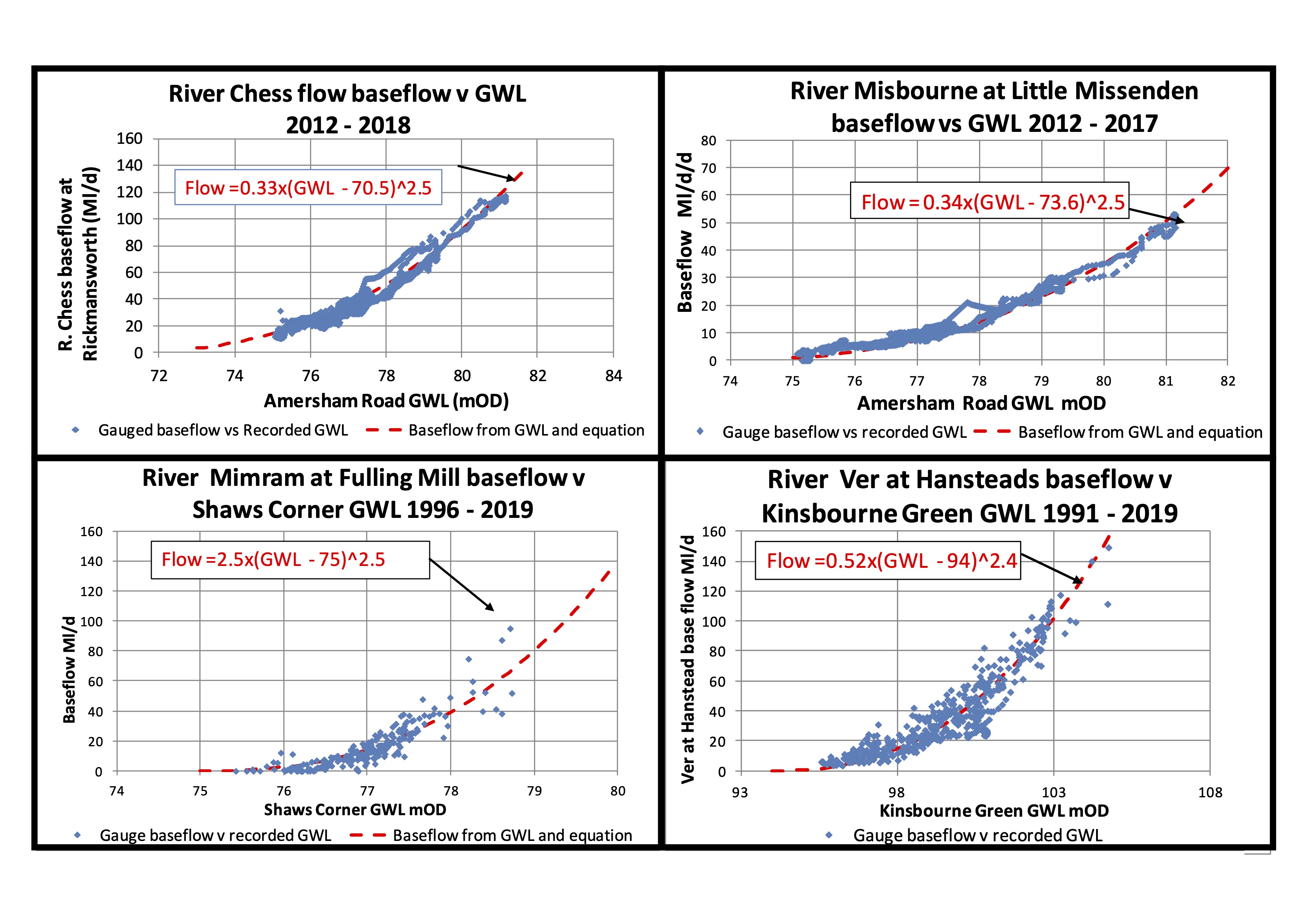
This shouldn’t be a debate about whether the Wessex Basin Model is more sophisticated than the CSF modelling. It clearly is.
The issue is whether the confidence placed in the Wessex reports conclusions is justified, given the limitations of the underlying data, the acknowledged uncertainties in conceptual understanding, and the internal inconsistencies in model performance across the Pimperne and Tarrant catchments and beyond to the edge of the Stour.
Data from an impacted system
All models are limited by the quality of the data that is fed into them — and here the data are limited and impacted. The Wessex model is built on:
- groundwater level records (largely post-1970),
- short-term stream flow gauging with spot meters (primarily 2015–2017)
- short-term targeted pumping and switch-off tests,
- a system that has been subject to decades of abstraction.
In other words, the model is based on data extracted from a system that is already altered from its natural state.
Without continuous flow records prior to the 1970s, and without direct measurements of groundwater–surface water interactions before large-scale abstraction, surely historical and qualitative evidence becomes more, not less, important? And yet it is largely excluded from the formal assessment.
Of course, Jane Dottridge wasn’t commissioned to comment on this other evidence. She nevertheless described it as “anecdotal”. I don’t think that’s fair. Anecdotal refers to an account or short narrative that is subjective, unreliable, or hearsay. Mapped Domesday mills are not anecdotal evidence.
Pimperne calibration
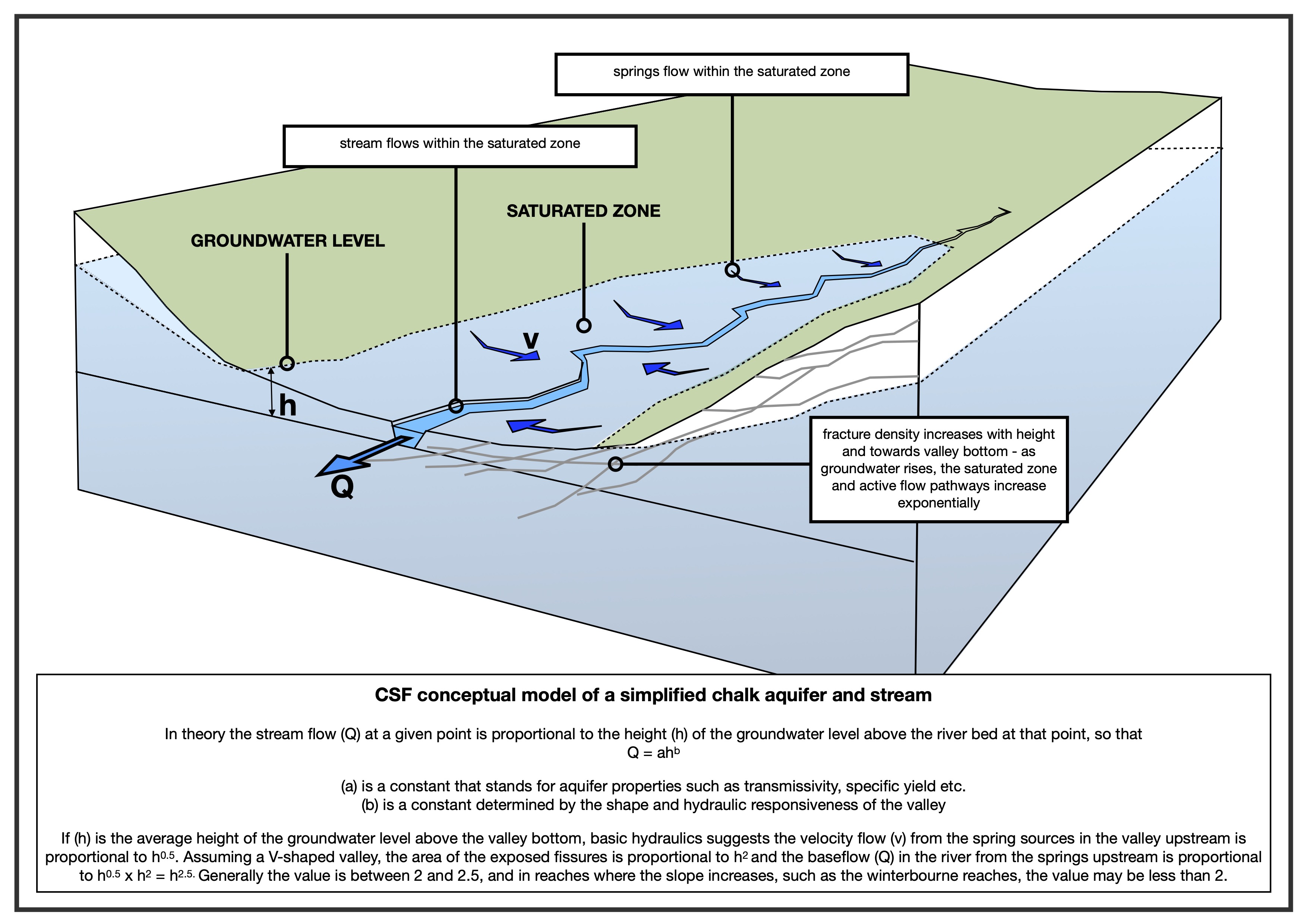
As to the models: Jane critiqued the one-dimensional simplicity of the CSF conceptual model. However, in spite of its attempts to capture the more complex reality, there is still uncertainty and assumption in the Wessex model, especially around the Pimperne–Tarrant interfluve.
Jane does highlight this: “the Pimperne calibration is not very good, with a very smooth modelled recession in contrast to the marked break in slope of the observations. Some of the gauges on the middle Tarrant (Rushton, Preston Farm) also show the same feature”
But she makes little of it. In the next paragraph Jane writes: “The conclusions appear to be justified based on the evidence presented in the report”
I don’t follow that logic. To recap, the conclusions of the report are:
- Tarrant: only the abstraction pump in the valley (Stubhampton) is relevant to flows in the Tarrant. The stream is negligibly impacted by this abstraction “along the perennial reach” * and the ecology is not adversely impacted.
- Pimperne: the abstraction at Black Lane does not impact flows in the Pimperne.
That is a very clear no impact statement given:
- The calibration is poor in the Pimperne and the lower Tarrant.
- The Black Lane abstraction is a high % of the catchment recharge.
- The groundwater boundary is modelled as fixed with no impact on the neighbouring Tarrant.
Surely the mismatch between the strength of no impact conclusions and the poor calibration warrants a furrowed brow.
* This is a variation on a rhetorical ploy I’ve seen before: if a stream is dry then abstraction is ipso facto not impacting the stream. It’s also evidence of my point about how the impacted state can become the new baseline. The RTPS contends that the lower river is naturally perennial.
Known knowns, known unknowns and unknown unknowns.
The Wessex report presents a conceptual model strategically refined by fieldwork that included stream-bed surveys, weekly observations and spot-flow measurements, new boreholes to investigate the interfluve, switch-off and pumping tests.
Accordingly, the model was refined to simulate lower transmissivity beneath interfluves, higher transmissivity in valley bottoms and the introduction of “unmapped faults” in the chalk – horizontal flow barriers – to improve calibration.
Surely these iterative refinements highlight, rather than resolve, the uncertainty? The interfluve behaviour was not predicted by earlier model versions, new borehole data required significant reinterpretation of the system and the fault-line is partly imposed through model structure, inferred – because the river dries – rather than directly observed in the geology.
The cornerstone conclusion ref the Tarrant — that abstractions outside the catchment have no impact — depends on the assumption of limited cross-interfluve connectivity. And yet groundwater catchments are known to shift with hydraulic gradients and Jane’s review confirms that groundwater boundaries can and often do vary over time and with rising and falling groundwater levels. If they do this, they can also vary because of abstraction pressure.
A central element of the Wessex argument is that switch-off and pumping tests define what they call “zones of influence” of abstractions and that impacts are therefore spatially limited.
This interpretation is not supported by general hydrogeological principles. Why does it pass, unchallenged?
Short-duration tests reveal immediate, local drawdown responses but do not capture longer-term system adjustment. They don’t capture the delayed propagation of pressure changes, the redistribution of groundwater flow paths, or slowly accreting capture from inter-connected water bodies.
The absence of observed drawdown at a location during a short test simply cannot be taken as evidence of no long-term hydrological impact.
Pick’n’mix
There is also evidence of expedient selectivity in the Wessex report and even Jane points this out. Where the Wessex model performs reasonably well – the Tarrant – it is used to support conclusions. Where it performs poorly – the Pimperne – then alternative methods are used: pump tests and empirical observations.
This pick’n’mix kind of undermines confidence in the whole thing surely? The analytical method is not consistent across the whole piece.
John’s CSF model may be pilloried for its simplicity, but at least it treats the whole study area in the same way. The Wessex Water approach ought to weaken the Environment Agency’s confidence in the system-wide conclusions, particularly those relating to this cross-catchment impacts we insist are plausible but which Wessex Water hotly denies.
What about 2017?
I’ve already underlined the coincidence between a long-term shut down 2016 to 2017 of the Black Lane pump in the neighbouring Pimperne valley and the fact that the summer of 2017 was the one year in the past ten that the lower Tarrant did not dry. This is such good evidence that the Black Lane pump may well be having an impact on the Tarrant, or the Black Lane and Shapwick pumps in tandem, especially when one remembers that the spring of 2017 was bad for chalk streams. That was the year that I took photographs of drying streams all round London, the Ver, Chess, Misbourne, Beane, Rib, Ash and others.
Wessex Water has an answer: they claim that late summer rain prevented the Tarrant from drying when it was otherwise on course to. I put this to John Lawson and he went away to look at the rainfall figures over a longer time-series, to see if this late summer rain was an anomaly that plausibly did make the difference.
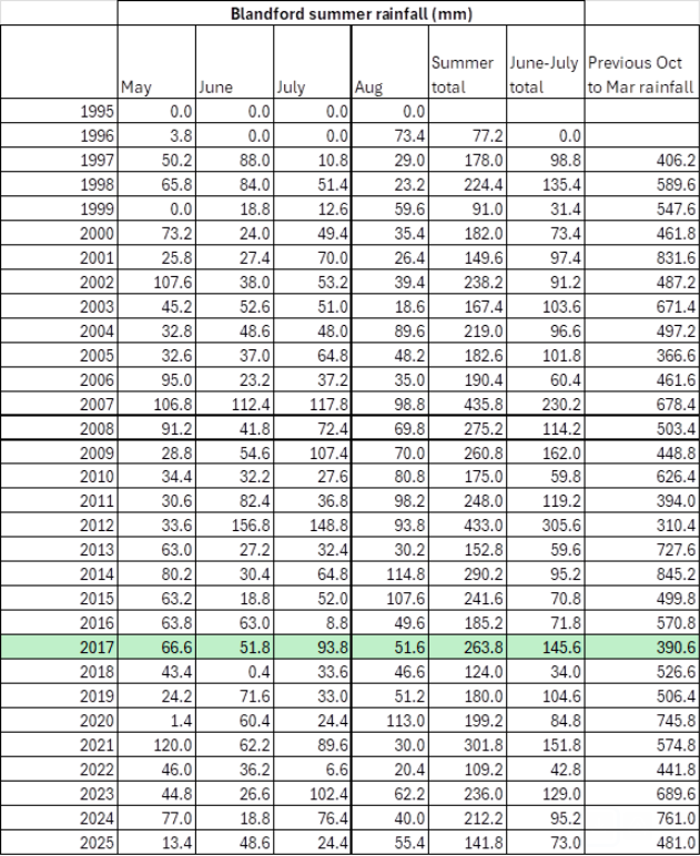
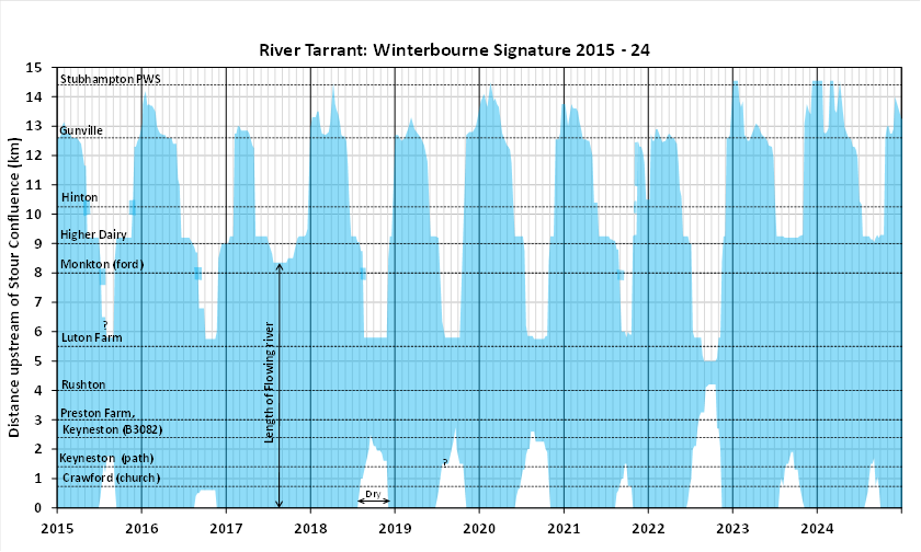
As you can see, the summers of 2015, 2021 and 2023 were similarly wet or wetter than 2017, but the river still dried. Whereas the the preceding October 2016 to March 2017 was unusually dry and that’s what usually determines flows in the following summer.
In summary
There is a mismatch between limited range of data (no consistent, long-term flow gauging), incomplete understanding of the aquifer, poor calibration in the modelling and confidence in the conclusions.
The purpose of highlighting these issues is not to suggest that “we are right and Wessex Water and the Environment Agency are wrong”. Instead it is to demonstrate that:
- alternative models produce plausible results which do suggest an abstraction impact,
- key assumptions (e.g. fixed catchment boundaries, limited zones of influence) are not definitively proven,
- the current evidence base does not support a strong “no impact” conclusion.
Given all the above surely it would be prudent to treat the current findings as provisional rather than definitive and look for a more robust truly independent investigation, with scope not limited to model comparison.
Let’s not forget, this stream is used for spawning by Atlantic salmon. The stream may not be as protected as the Bourne and Wylye, but the salmon is. These fish are genetically unique to chalk streams and the Stour’s population of these fish must be the most endangered stock of all.
Oh and just one more thing …
Underlining the mismatch between what we know and confidence in conclusions, it is worth addicting that recent research into the Chalk aquifer by Andy Farrant and others at the BGS has highlighted the greater-than-previously-recognised role of karstic dissolution features and preferential flow pathways in chalk. These can provide localised areas of enhanced permeability that are not necessarily captured in regional groundwater models. Hydraulic connectivity may well occur along pathways that are not predicted by averaged aquifer properties or detected by limited observation boreholes. This must be relevant where abstraction alters hydraulic gradients, potentially activating or enhancing flow along such pathways?
Sure, this does not demonstrate that such connections exist between the Pimperne and Tarrant catchments, it does underline the uncertainty associated with assuming that lower-transmissivity interfluves act as hard hydraulic boundaries.
Just saying …