In some ways eco-warrior Paul Powlesland has the sort of zeal we need much more of. He cares enough about an overlooked London river to spend his own money trying to improve it. So, when the Environment Agency wrote to him warning that it was investigating works he’d done on the Alders Brook without a permit, it looked once again like a bureaucracy that had lost its purpose, persecuting someone trying to do the right thing.
I met Paul briefly a couple of years ago after he had given a talk on the Rights of Rivers, for which he is a passionate advocate. Curious about the arguments in favour, I had nevertheless been unconvinced. I couldn’t see what the granting of rights would do to improve a river’s health over and above the application of existing (or improved) environmental laws.
This kerfuffle with the Agency hasn’t done much to sway my scepticism. In fact, it begs the same question I had wanted to ask Paul as he rushed to the train station: “Once a river has rights, who will best speak for it?” A river’s interests aren’t always that obvious and the path to hell is paved with good intentions.
The story of Powlesland’s run-in with Agency has been very widely reported: splashed across The Guardian and The Daily Telegraph, featured in Channel 4 news, retold as far afield as The Times of India and all over social media. The stories all suggest that Powlesland was being threatened with prosecution for removing rubbish from a river, which on the face of it is absurd.
That didn’t quite ring true for me. The good folk of the River Wandle Trust have been taking rubbish out of that south London river for decades, without ever falling foul of the Environment Agency. They have done this work with the cooperation of the local council, who have provided lorries to take away the vast quantities of stuff that other no-so-good folk of south London insist on throwing in there: mattresses, tyres, shopping trolleys. You name it.

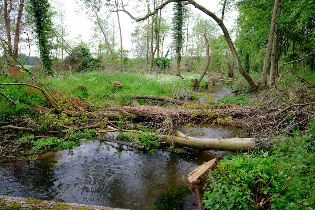
I couldn’t imagine why on the Earth the Agency would want to harry Powlesland for litter picking, and I suspected that they didn’t. I suspected, in fact, that they had taken exception to something else. The words “silt and weed” in The Guardian headline made me suspicious. The mention in The Daily Telegraph of the use of an excavator hired by Powlesland for £750 made me more suspicious. You don’t need an excavator to pick litter. So, had he actually dredged the river of “silt and weed” in the name of cleaning it up?
Sure enough, when the Agency finally relented and informed Powlesland that they wouldn’t be taking further action the letter alluded to “flood risk activity” consisting of “dredging, raising or taking of any sand, silt, ballast, clay, gravel off the bed or banks of the Alder’s Brook”. Somewhere on the Roding Trust Facebook feed there is a film of a digger slubbing mud out of the channel. Harmless enough, perhaps, but ordinary mortals do need consent for that kind of work, so to just crack on without it and post the evidence …
Clearly, Powlesland is very much motivated to do the right thing. Clearly, he is frustrated by what he sees as petty-fogging bureaucracy standing in his way.
But so was John Price, a farmer who was jailed for 12 months for taking an excavator into the River Lugg and dredging the bed of that highly protected river. John Price’s crime was far, far worse than Powlesland’s intervention, but the point is … John Price thought he was doing the right thing too. He thought he was protecting the village from flooding. And the media, en masse, portrayed him as a Robin Hood hero. He wasn’t. He badly damaged salmon spawning grounds, and if anything, his tidying up of the River Lugg will have made the flooding worse.
Powlesland’s work on the Alders Brook won’t have done either of those things, but if he dredged silt out of it he may have temporarily stirred up pollutants and caused oxygen depletion downstream. Besides, dredging silt out of the Alders Brook is also a Canute-like exercise.
The Alders Brook is not a tributary of the River Roding, as described in the newspaper reports. It is the natural course of the upper reaches of the tidal River Roding. Further down the valley the same relic natural course was once called The Back Water and is now almost entirely erased. The first edition Ordnance Survey marks the head of the Alders Brook where it leaves the diverted course of the modern River Roding, with the words “Ford. Ordinary Tides flow to this point”.

The diversion of the modern river course flowed from there to a paper mill in the village of Great Ilford. No doubt the paper mill is long since obsolete but the modified course and its impact on river morphology remains. The Alders Brook is not a free-flowing stream, rather a part relic of a tidal estuary. Once it would have drained under gravity twice a day, and this would have kept its main channel free of accumulating sediment. But estuaries are, by their nature, muddy places where any interruption to gradient will gather silt and mud. The upper parts the Alders Brook have natural gradient, but the lowermost reach takes a sharp, unnatural turn to the east, and if anything, the river is trying to climb uphill as it rejoins the much diverted and much modified main Roding. It is, therefore, a sump and will always fill with silt.

Throughout eastern England, we’ve done stuff like this: we have boxed in estuarial reaches of rivers and reclaimed the land either side of them. Now, they can be miles from the sea with all vestiges of that transient landscape buried under trading estates, retail parks and railway lines, and the expectation is that these meandering courses should behave like rivers. They can’t.
Removing accumulated silt may look like restoration, but unless the free-flowing tidal processes that once maintained the channel are also fully restored—which, in urban east London, is impossible —the exercise becomes one of perpetual maintenance.
None of this is to question Powlesland’s motives, which are clearly driven by a passion to improve his local river. But that doesn’t mean every enthusiastic intervention should simply be waved on through without the troubling business of conforming to the consenting process.
And it does beg a question about river rights. In the few places these have been enacted they’re just too vague to be meaningful: “the right to flow” “the right to be free from pollution”. For all our failures to actually impose environmental laws, these laws protect rivers in terms that are generally much clearer.
Rights would require somebody to speak on behalf of the rights-holder and who is best going to do that when one person’s idea of an improvement may be another person’s idea of environmental damage? A river that looks untidy may actually be a haven for wildlife. A fallen tree might look like obstruction, when it’s actually habitat. Silt looks dirty when it might be the stucture of the channel. Weeds look like neglect when they are vital to the flow, temperature, oxygen and nurient levels.
Passionate river guardians standing up for vague rights and emboldened to act unilaterally without consent because they feel that right is on their side: that could just as well become an army of John Prices, as an army of Paul Powleslands. We should be careful what we wish for.
The Roding Trust volunteers go out in all weathers and do hard work to make their corner of the planet better. We need their passion, for sure. The Environment Agency were a bit heavy-hoofed in this case, and that didn’t sit well in the context of their reluctance to prosecute much more obvious and damaging environmental offences. Powlesland has described dozens of illegal discharges of raw sewage upstream on the same river: Theydon Bois works, for example, spilled 85 times in 2025. Not all of those can have been in “exceptional weather”.
But right now, if I want to restore a river I have to draw up a plan, back it with evidence and apply for permission. The application procedure is frustratingly slow and sometimes the edicts from the folk granting or denying permission feel baffling, or obstructive. I wish the process could be better and argue that it should be. But on the other hand, if we want the Environment Agency to protect rivers, then we shouldn’t object too hard when it does.
Coda.
So, if the Roding Trust can’t meaningfully restore the estuarial Alders Brook because there’s just too much of London in the way, what could they do to revive it and create a lovely waterscape? I seriously doubt the brook serves any flood relief function nowadays: so, bearing in mind it can’t become free-flowing again and will always be a silt trap, I’d cut off the inflow and outflow and turn it into a meandering still-water. This way, silt would take much, much longer to accrete and could be carefully removed once a decade by suction. It would be clear-watered and full of life and pretty enough— one hopes— to shame even the worst of litterbugs.
The project would require consent, however.